Eskdale Corn Mill

Log in to your account

AroundUs is a community-driven map of interesting places, built by curious explorers like you. It grows with every review, story, and photo you share.
Connect to save your favorite spots, contribute locations, and create personalized routes.
By continuing, you accept our Terms and Conditions and our Privacy Policy
Add to collection
Map
Suggest a change
Share

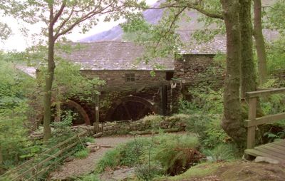
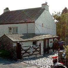
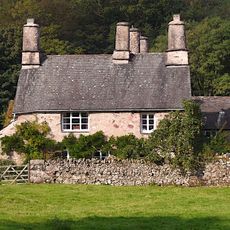
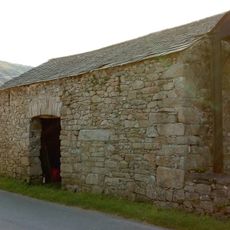
Eskdale Corn Mill, Historic corn mill in Eskdale, England
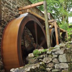
The T-shaped mill structure contains two low storeys and features two 12-foot overshot water wheels on its east side for grain processing.

Constructed in 1547, the mill underwent modifications during the 18th century with the addition of a second water wheel and improvements to its stone structure.

The mill stands as a demonstration of traditional grain processing methods, with preserved wooden machinery illustrating agricultural practices from past centuries.

The Eskdale Mill & Heritage Trust maintains regular opening hours for visitors to explore the internal mechanisms and learn about historical milling processes.

The building contains an extensive collection of original wooden machinery that continues to demonstrate traditional corn milling techniques from centuries past.

Location: Eskdale

GPS coordinates: 54.39910,-3.27009

Latest update: March 4, 2025 16:42

Historic sites and nature spots in Cumbria

Cumbria features medieval churches, watermills, prehistoric stone circles and Roman ruins. The region houses historic mansions like Sizergh Castle and Hutton in the Forest. Nature enthusiasts can explore limestone formations, waterfalls and Ennerdale Lake. Literature fans can visit William Wordsworth's birthplace and residence.

Around this place
Show the full map
Hardknott Roman Fort
United Kingdom

Hardknott Roman Fort

4.2 km
Harter Fell
United Kingdom

Harter Fell

4.5 km
Cairnfield including a prehistoric enclosure, 5 stone circles, 10 funerary cairns, 6 stone banks, 2 stone walls, a lynchet and a
United Kingdom

Cairnfield including a prehistoric enclosure, 5 stone circles, 10 funerary cairns, 6 stone banks, 2 stone walls, a lynchet and a

1.4 km
Illgill Head
United Kingdom

Illgill Head

3.9 km
Slight Side
United Kingdom

Slight Side

5.1 km
Green Crag
United Kingdom

Green Crag

3.7 km
St Catherine's Church, Boot
United Kingdom

St Catherine's Church, Boot

891 m
Eskdale Centre
United Kingdom

Eskdale Centre

3.4 km
St Bega's Church
United Kingdom

St Bega's Church

3.6 km
Church of St Michael and All Angels
United Kingdom

Church of St Michael and All Angels

5.9 km
Eskdale Mill
United Kingdom

Eskdale Mill

4 m
Bridge Over Whillan Beck To South West Of Corn Mill
United Kingdom

Bridge Over Whillan Beck To South West Of Corn Mill

22 m
Doctor Bridge
United Kingdom

Doctor Bridge

1.4 km
Eskdale War Memorial
United Kingdom

Eskdale War Memorial

776 m
Forge House With Attached Barn, Stable And Byres
United Kingdom

Forge House With Attached Barn, Stable And Byres

3.5 km
K6 Telephone Kiosk
United Kingdom

K6 Telephone Kiosk

3.5 km
Bridge End Farmhouse
United Kingdom

Bridge End Farmhouse

58 m
Boot House And Whillanside
United Kingdom

Boot House And Whillanside

40 m
Dalegarth Hall
United Kingdom

Dalegarth Hall

1.2 km
Barn West Of Forge House
United Kingdom

Barn West Of Forge House

3.5 km
Barn To South West Of Whillanside
United Kingdom

Barn To South West Of Whillanside

51 m
Building To South West Of Corn Mill On East Side Of Road At North End Of Bridge
United Kingdom

Building To South West Of Corn Mill On East Side Of Road At North End Of Bridge

14 m
Boundary Stone Circa 15 Feet East Of Overbeck Bridge On North Side Of Road
United Kingdom

Boundary Stone Circa 15 Feet East Of Overbeck Bridge On North Side Of Road

5.7 km
Barn To North West Of Bridge End Farmhouse
United Kingdom

Barn To North West Of Bridge End Farmhouse

57 m
Great Crag prehistoric cairnfield and associated field system 710m south east of Birkerthwaite
United Kingdom

Great Crag prehistoric cairnfield and associated field system 710m south east of Birkerthwaite

3.6 km
Prehistoric cairnfield, associated field system and hut circle      east of Water Crag
United Kingdom

Prehistoric cairnfield, associated field system and hut circle east of Water Crag

4.3 km
Prehistoric enclosure, hut circle and adjacent cairnfield east of Whillan Beck, Burnmoor
United Kingdom

Prehistoric enclosure, hut circle and adjacent cairnfield east of Whillan Beck, Burnmoor

2.5 km
Maiden Castle round cairn, Burnmoor
United Kingdom

Maiden Castle round cairn, Burnmoor

4.4 km
Show the full map

Reviews

Visited this place? Tap the stars to rate it and share your experience / photos with the community! Try now! You can cancel it anytime.

« Eskdale Corn Mill - Historic corn mill in Eskdale, England » is provided by Around Us (aroundus.com). Images and texts are derived from Wikimedia project under a Creative Commons license. You are allowed to copy, distribute, and modify copies of this page, under the conditions set by the license, as long as this note is clearly visible.

Discover hidden gems everywhere you go!

From secret cafés to breathtaking viewpoints, skip the crowded tourist spots and find places that match your style. Our app makes it easy with voice search, smart filtering, route optimization, and insider tips from travelers worldwide. Download now for the complete mobile experience.

Around Us App Screenshot

A unique approach to discovering new places

Le Figaro

All the places worth exploring

France Info

A tailor-made excursion in just a few clicks

20 Minutes