Enable Location

We need your location to show you interesting places around you

Discover nearby places

Find interesting locations and hidden gems around you

Precise directions

Get accurate directions and distances to places

Your location is never shared with other users. It's only used when you tap the location button.

Milecastle 29

Log in to your account

Start exploring — it's free

Trusted by 62,915 travelers worldwide

Continue with Google
Continue with Apple
or

We will send you a code to connect

By continuing, you accept our Terms and Conditions and our Privacy Policy

Check your inbox

We've sent a pincode in your inbox. Please enter the code below.

Milecastle 29
Discussion Reviews 1 Photos
1.7k Popularity

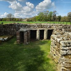
Milecastle 29, Roman fortification in Northumberland, England.

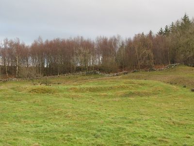
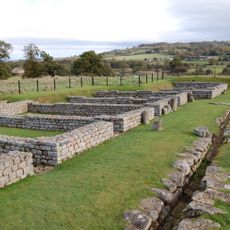
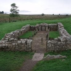
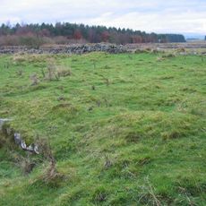
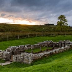
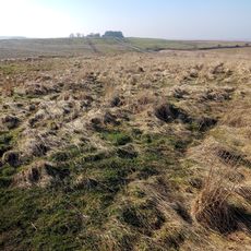
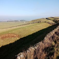
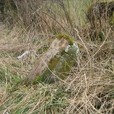
Milecastle 29 is a Roman fortification in Northumberland consisting of a rectangular platform surrounded by deep trenches, situated near the B6318 Military Road. The structure preserves traces of its gateway openings and the interior layout that once housed a small garrison.

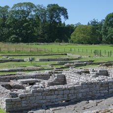
Built in the 2nd century AD under Emperor Hadrian's command, this milecastle formed part of a frontier defense network stretching across northern Britain. Soldiers stationed here monitored movement along the wall and provided accommodation for troops patrolling the region.

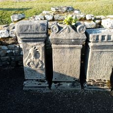
The site shows how Roman soldiers built their frontier installations through the placement of gates and drainage channels that visitors can still observe today. Walking through it reveals practical engineering choices made over 2,000 years ago.

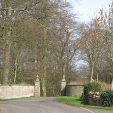
The site is accessible via the Hadrian's Wall National Trail, which links various archaeological sites across the region. Sturdy footwear is recommended as the ground is uneven and the weather can change quickly.

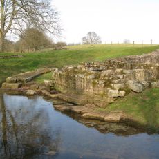
The site retains visible remains of its surrounding ditch system, including a rarely preserved causeway crossing opposite the southern entrance. These features reveal how Romans engineered water-based defenses.

The community of curious travelers

AroundUs brings together thousands of curated places, local tips, and hidden gems, enriched daily by 60,000 contributors worldwide.

Start exploring
Location
Part of
Hadrian's Wall
GPS coordinates
55.03427,-2.17543
Latest update
December 14, 2025 12:22
Around this place
Chesters Roman Fort
United Kingdom

Chesters Roman Fort

2.5 km
Carrawburgh
United Kingdom

Carrawburgh

3 km
Chesters Bridge
United Kingdom

Chesters Bridge

2.7 km
Chesters
United Kingdom

Chesters

2.2 km
Walwick Grange
United Kingdom

Walwick Grange

2.6 km
Milecastle 30
United Kingdom

Milecastle 30

1.4 km
Chesters Roman Fort
United Kingdom

Chesters Roman Fort

2.5 km
Milecastle 27
United Kingdom

Milecastle 27

3 km
Milecastle 28
United Kingdom

Milecastle 28

1.6 km
Church of St Mungo, Simonsburn
United Kingdom

Church of St Mungo, Simonsburn

3.1 km
Coventina's Well
United Kingdom

Coventina's Well

3.1 km
Thornton Tower
United Kingdom

Thornton Tower

3.1 km
The George Inn
United Kingdom

The George Inn

3.1 km
Clayton Museum
United Kingdom

Clayton Museum

2.4 km
Carrawburgh Roman fort and Hadrian's Wall and vallum
United Kingdom

Carrawburgh Roman fort and Hadrian's Wall and vallum

3.1 km
Brocolitia Mithraic temple
United Kingdom

Brocolitia Mithraic temple

3 km
Simonburn War Memorial, Village Green
United Kingdom

Simonburn War Memorial, Village Green

3 km
Little Walwick
United Kingdom

Little Walwick

1.5 km
Humshaugh War Memorial
United Kingdom

Humshaugh War Memorial

2.7 km
Power House To North East Of Newbrough Hall
United Kingdom

Power House To North East Of Newbrough Hall

3.1 km
Brocolitia Roman fort
United Kingdom

Brocolitia Roman fort

3 km
Milepost On North Side Of Road Junction At Keepershield
United Kingdom

Milepost On North Side Of Road Junction At Keepershield

2 km
Pant Beside Road 200 Metres North Of Junction By Heatheridge
United Kingdom

Pant Beside Road 200 Metres North Of Junction By Heatheridge

1.9 km
The Roman fort, vicus, bridge abutments and associated remains of Hadrian's Wall at Chesters in wall mile 27
United Kingdom

The Roman fort, vicus, bridge abutments and associated remains of Hadrian's Wall at Chesters in wall mile 27

2.3 km
Stable Block 200 Metres North Of Chesters
United Kingdom

Stable Block 200 Metres North Of Chesters

2.1 km
Garden Wall To West End Terrace And Evans Almshouse, With Attached Pant
United Kingdom

Garden Wall To West End Terrace And Evans Almshouse, With Attached Pant

3 km
Hadrian's Wall and vallum between the road to Simonburn and the field boundary east of Carrawburgh car park in wall miles 29, 30 and 31
United Kingdom

Hadrian's Wall and vallum between the road to Simonburn and the field boundary east of Carrawburgh car park in wall miles 29, 30 and 31

1.6 km
Milestone, Rye Hill, Walwick
United Kingdom

Milestone, Rye Hill, Walwick

302 m
Show the full map
Reviews
Share your experience

No review yet

Discussions
Start a discussion...

No discussion yet

« Milecastle 29 - Roman fortification in Northumberland, England » is provided by Around Us (aroundus.com). Images and texts are derived from Wikimedia project under a Creative Commons license. You are allowed to copy, distribute, and modify copies of this page, under the conditions set by the license, as long as this note is clearly visible.

Discover hidden gems everywhere you go!

From secret cafés to breathtaking viewpoints, skip the crowded tourist spots and find places that match your style. Our app makes it easy with voice search, smart filtering, route optimization, and insider tips from travelers worldwide. Download now for the complete mobile experience.

Around Us App Screenshot

A unique approach to discovering new places

Le Figaro

All the places worth exploring

France Info

A tailor-made excursion in just a few clicks

20 Minutes

Around Us
Travel Guide & Maps
Download

Send to your phone

QR Code
1

Open the camera app on your mobile.

2

Point at the QR code with your camera. A notification will appear.

3

Tap the notification to open the link.