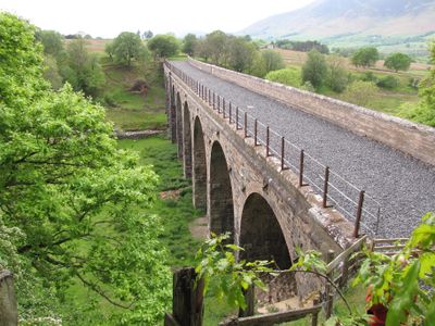
Mosedale Viaduct, Railway viaduct in Matterdale, England
Mosedale Viaduct is a stone railway bridge with 12 arches spanning a valley between two villages, built from locally sourced materials. The arches are made of carefully placed stones designed to support the weight of passing trains over the beck below.
The structure was built in 1862 to serve a railway line connecting local towns across the Pennines. It remained in use through major changes to the rail network until service stopped in 1972.
The structure shows how railways changed connections between local communities and shaped daily travel patterns in the valley. Visitors walking beneath or around it can see how thoroughly Victorian engineering transformed rural landscapes.
The viaduct is located between two villages and can be reached on foot from either settlement. Sturdy shoes are recommended as you explore the area on paths and fields around the structure.
The structure narrowly escaped demolition in the 1990s when preservation plans emerged linked to proposals for reopening the railway. Few Victorian bridges have been saved by such optimistic visions of renewed rail service.
Location: Matterdale
Location: Threlkeld
Inception: 1862
GPS coordinates: 54.62356,-3.00025
Latest update: December 14, 2025 14:23
Blencathra
4.6 km
Clough Head
3.9 km
Great Mell Fell
4.2 km
Threlkeld Quarry and Mining Museum Railway
3.2 km
Hart Side
6.1 km
Bowscale Fell
5.2 km
Mungrisdale Common
5.5 km
High Rigg
6 km
Great Dodd
5.5 km
Souther Fell
3.3 km
Bannerdale Crags
3.7 km
St John's Church, St John's in the Vale
5.9 km
Matterdale Church
5.2 km
Church of St Mary
3.4 km
Church of St Kentigern, Mungrisdale
4.7 km
Friends' Meeting House And Adjoining Stables
6.4 km
Boundary Stone South Of Moss Dyke
5.5 km
Horse and Farrier Inn and adjoining house
3.3 km
Threlkeld Quarry And Mining Museum
3.8 km
Milestone At Ny 354 267
912 m
Milestone, Shundraw T jct
5.4 km
Milestone, Entrance to Lisco Farm
2 km
Milestone, Gate Crag, Scales
1.8 km
Milestone, Wood End, E end of village
2.9 km
Milestone, West Threlkeld, A66 jct W road to village
4.1 km
Milestone, Right entrance to Far Howe
3.3 km
Milestone, Storms Farm
6.2 km
Replacement Milestone, Storms Farm
6.2 kmVisited this place? Tap the stars to rate it and share your experience / photos with the community! Try now! You can cancel it anytime.
Discover hidden gems everywhere you go!
From secret cafés to breathtaking viewpoints, skip the crowded tourist spots and find places that match your style. Our app makes it easy with voice search, smart filtering, route optimization, and insider tips from travelers worldwide. Download now for the complete mobile experience.
A unique approach to discovering new places❞
— Le Figaro
All the places worth exploring❞
— France Info
A tailor-made excursion in just a few clicks❞
— 20 Minutes