Enable Location

We need your location to show you interesting places around you

Discover nearby places

Find interesting locations and hidden gems around you

Precise directions

Get accurate directions and distances to places

Your location is never shared with other users. It's only used when you tap the location button.

David Taylor Model Basin

Log in to your account

Start exploring — it's free

Trusted by 62,376 travelers worldwide

Continue with Google
Continue with Apple
or

We will send you a code to connect

By continuing, you accept our Terms and Conditions and our Privacy Policy

Check your inbox

We've sent a pincode in your inbox. Please enter the code below.

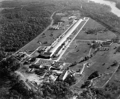
David Taylor Model Basin, Ship model basin at Naval Surface Warfare Center Carderock Division, United States.

The David Taylor Model Basin is a ship testing facility at Naval Surface Warfare Center Carderock Division with three testing sections: a deep water basin, a shallow water basin, and a high-speed basin for naval research. The facility uses wave makers and measurement equipment to evaluate how vessel models perform and respond to different water conditions.

This research facility was built in 1939 to meet the need for advanced ship testing capabilities during a period of naval expansion before World War II. The project reflected the growing understanding that precise model testing was essential for developing more reliable vessels.

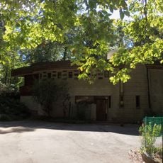
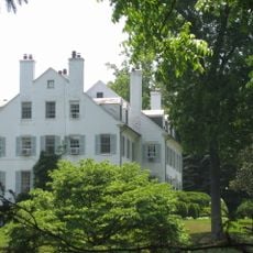
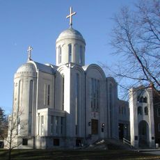
The main building displays Art Deco features through geometric patterns and pronounced vertical lines characteristic of 1930s federal architecture. These design elements shape the visual character of the complex and reflect the styling preferences of that era.

The site sits on a naval property and visits are typically limited to scheduled tours or special open days. It is wise to inquire ahead of time since access to active research areas may be restricted for security reasons.

The deep water basin features 216 electro-mechanical panels that generate precise wave patterns to simulate various ocean conditions. This complex system allows engineers to recreate scenarios that would otherwise be difficult to reproduce in standard testing.

The community of curious travelers

AroundUs brings together thousands of curated places, local tips, and hidden gems, enriched daily by 60,000 contributors worldwide.

Start exploring
Inception
1939
Architectural style
Art Deco architecture
Elevation above the sea
39 m
GPS coordinates
38.97500,-77.19170
Latest update
December 7, 2025 20:21
Around this place
Kryptos
United States of America

Kryptos

4.7 km
CIA Memorial Wall
United States of America

CIA Memorial Wall

4.7 km
Hickory Hill
United States of America

Hickory Hill

4.3 km
Congressional Country Club
United States of America

Congressional Country Club

2.7 km
United States of America

Project CHATTER

8.9 km
Chesapeake and Ohio Canal National Historical Park
United States of America

Chesapeake and Ohio Canal National Historical Park

9.5 km
CIA Museum
United States of America

CIA Museum

4.7 km
TPC Potomac at Avenel Farm
United States of America

TPC Potomac at Avenel Farm

3.3 km
American Legion Memorial Bridge
United States of America

American Legion Memorial Bridge

1.2 km
Claude Moore Colonial Farm
United States of America

Claude Moore Colonial Farm

4.2 km
Union Arch Bridge
United States of America

Union Arch Bridge

3.8 km
Robert Llewellyn Wright House
United States of America

Robert Llewellyn Wright House

4.2 km
Mather Gorge
United States of America

Mather Gorge

3.9 km
Scott's Run Nature Preserve
United States of America

Scott's Run Nature Preserve

1.4 km
Salona
United States of America

Salona

4.5 km
Cabin John Creek
United States of America

Cabin John Creek

4 km
Virginia State Route 193
United States of America

Virginia State Route 193

2.2 km
Plummers Island
United States of America

Plummers Island

1.5 km
Langley Fork Historic District
United States of America

Langley Fork Historic District

4.2 km
Chautauqua Tower
United States of America

Chautauqua Tower

4.7 km
Carderock Springs Historic District
United States of America

Carderock Springs Historic District

2.6 km
Orthodox Church in America Diocese of Washington
United States of America

Orthodox Church in America Diocese of Washington

3 km
Clara Barton National Historic Site
United States of America

Clara Barton National Historic Site

4.5 km
Lock 7
United States of America

Lock 7

4.7 km
Lock 10
United States of America

Lock 10

2 km
Lock 8
United States of America

Lock 8

2.7 km
Lock 9
United States of America

Lock 9

2.2 km
Washington Aqueduct Bridge No. 3
United States of America

Washington Aqueduct Bridge No. 3

1.8 km
Show the full map
« David Taylor Model Basin - Ship model basin at Naval Surface Warfare Center Carderock Division, United States » is provided by Around Us (aroundus.com). Images and texts are derived from Wikimedia project under a Creative Commons license. You are allowed to copy, distribute, and modify copies of this page, under the conditions set by the license, as long as this note is clearly visible.

Discover hidden gems everywhere you go!

From secret cafés to breathtaking viewpoints, skip the crowded tourist spots and find places that match your style. Our app makes it easy with voice search, smart filtering, route optimization, and insider tips from travelers worldwide. Download now for the complete mobile experience.

Around Us App Screenshot

A unique approach to discovering new places

Le Figaro

All the places worth exploring

France Info

A tailor-made excursion in just a few clicks

20 Minutes

Around Us
Travel Guide & Maps
Download

Send to your phone

QR Code
1

Open the camera app on your mobile.

2

Point at the QR code with your camera. A notification will appear.

3

Tap the notification to open the link.