Enable Location

We need your location to show you interesting places around you

Discover nearby places

Find interesting locations and hidden gems around you

Precise directions

Get accurate directions and distances to places

Your location is never shared with other users. It's only used when you tap the location button.

Virginia State Route 193

Log in to your account

Start exploring — it's free

Trusted by 63,118 travelers worldwide

Continue with Google
Continue with Apple
or

We will send you a code to connect

By continuing, you accept our Terms and Conditions and our Privacy Policy

Check your inbox

We've sent a pincode in your inbox. Please enter the code below.

Discussion Reviews 1 Photos
3k Popularity

Virginia State Route 193, Historic transportation route in Fairfax County, United States.

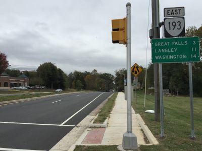
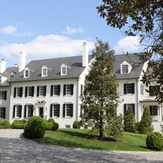
Virginia State Route 193 is a road that extends roughly 12 miles from State Route 7 in Dranesville to State Route 123 in Langley, running through Arlington and Fairfax Counties. The route passes through residential areas with many sharp curves and widens to four lanes near the Interstate 495 interchange in McLean.

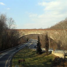
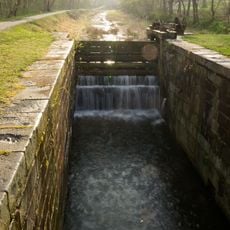
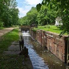
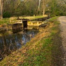
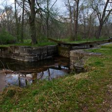
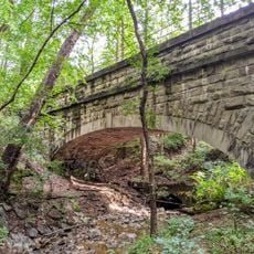
The road was constructed between 1813 and 1827 using stone techniques that represented advanced engineering for the early 1800s. It was added to the National Register of Historic Places in 1974 to recognize its role in the region's transportation development.

The National Register of Historic Places designation in 1974 recognizes the road's contribution to regional development and transportation infrastructure in Northern Virginia.

Drivers should expect numerous curves through the residential sections, especially on the narrower portions. The four-lane expanded section near McLean offers better driving conditions and sight lines on that stretch.

Original retaining walls, culverts, and arches from the initial construction remain visible along the route and show nineteenth-century road building techniques. These old structures offer glimpses into early American engineering and are often overlooked by travelers.

The community of curious travelers

AroundUs brings together thousands of curated places, local tips, and hidden gems, enriched daily by 60,000 contributors worldwide.

Start exploring
Location
Location
GPS coordinates
38.95640,-77.19890
Latest update
December 12, 2025 12:05
Around this place
Kryptos
United States of America

Kryptos

4.6 km
George Bush Center for Intelligence
United States of America

George Bush Center for Intelligence

4.7 km
CIA Memorial Wall
United States of America

CIA Memorial Wall

4.6 km
Hickory Hill
United States of America

Hickory Hill

3.5 km
Congressional Country Club
United States of America

Congressional Country Club

4.8 km
United States of America

Project CHATTER

10.3 km
Chesapeake and Ohio Canal National Historical Park
United States of America

Chesapeake and Ohio Canal National Historical Park

9 km
Capital One Tower
United States of America

Capital One Tower

3.6 km
David Taylor Model Basin
United States of America

David Taylor Model Basin

2.2 km
CIA Museum
United States of America

CIA Museum

4.6 km
American Legion Memorial Bridge
United States of America

American Legion Memorial Bridge

2.3 km
Tysons Corner Communications Tower
United States of America

Tysons Corner Communications Tower

4.8 km
Claude Moore Colonial Farm
United States of America

Claude Moore Colonial Farm

3.9 km
Union Arch Bridge
United States of America

Union Arch Bridge

4.8 km
Mather Gorge
United States of America

Mather Gorge

4.1 km
Scott's Run Nature Preserve
United States of America

Scott's Run Nature Preserve

739 m
Cabin John Creek
United States of America

Cabin John Creek

4.8 km
Plummers Island
United States of America

Plummers Island

2.4 km
Langley Fork Historic District
United States of America

Langley Fork Historic District

3.6 km
Carderock Springs Historic District
United States of America

Carderock Springs Historic District

4.5 km
Orthodox Church in America Diocese of Washington
United States of America

Orthodox Church in America Diocese of Washington

1.9 km
Lock 10
United States of America

Lock 10

3.2 km
Lock 8
United States of America

Lock 8

3.7 km
Lock 9
United States of America

Lock 9

3.3 km
Lock 14
United States of America

Lock 14

2.3 km
1750 Tysons Boulevard
United States of America

1750 Tysons Boulevard

4.2 km
Washington Aqueduct Bridge No. 3
United States of America

Washington Aqueduct Bridge No. 3

3.1 km
1650 Tysons Boulevard
United States of America

1650 Tysons Boulevard

4.1 km
Show the full map
Reviews
Share your experience

No review yet

Discussions
Start a discussion...

No discussion yet

« Virginia State Route 193 - Historic transportation route in Fairfax County, United States » is provided by Around Us (aroundus.com). Images and texts are derived from Wikimedia project under a Creative Commons license. You are allowed to copy, distribute, and modify copies of this page, under the conditions set by the license, as long as this note is clearly visible.

Discover hidden gems everywhere you go!

From secret cafés to breathtaking viewpoints, skip the crowded tourist spots and find places that match your style. Our app makes it easy with voice search, smart filtering, route optimization, and insider tips from travelers worldwide. Download now for the complete mobile experience.

Around Us App Screenshot

A unique approach to discovering new places

Le Figaro

All the places worth exploring

France Info

A tailor-made excursion in just a few clicks

20 Minutes

Around Us
Travel Guide & Maps
Download

Send to your phone

QR Code
1

Open the camera app on your mobile.

2

Point at the QR code with your camera. A notification will appear.

3

Tap the notification to open the link.