Enable Location

We need your location to show you interesting places around you

Discover nearby places

Find interesting locations and hidden gems around you

Precise directions

Get accurate directions and distances to places

Your location is never shared with other users. It's only used when you tap the location button.

Tysons Corner Communications Tower

Log in to your account

Start exploring — it's free

Trusted by 63,120 travelers worldwide

Continue with Google
Continue with Apple
or

We will send you a code to connect

By continuing, you accept our Terms and Conditions and our Privacy Policy

Check your inbox

We've sent a pincode in your inbox. Please enter the code below.

Tysons Corner Communications Tower
Discussion Reviews 1 Photos
7.4k Popularity

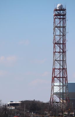
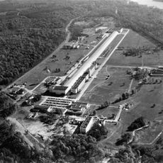
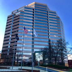
Tysons Corner Communications Tower, Military communications tower in Tysons Corner, Virginia, US.

The Tysons Corner Communications Tower is a telecommunications facility in Virginia that manages government communications. It serves as a relay point for secure data transmission between Washington and other installations across the country.

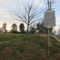
The facility was built in 1952 during the Cold War as part of a strategic network maintaining connections between government and military forces. It played a role in the communications systems developed during that tense period.

The structure, known as Site E among military personnel, represents a physical reminder of the ongoing importance of secure communications in national defense.

Many original microwave antennas were removed and replaced with underground fiber-optic cables connecting to various government facilities. Keep in mind this is a restricted access area.

Military officials at Fort Belvoir manage this classified facility, which maintains undisclosed operations and potential connections to intelligence communications networks.

The community of curious travelers

AroundUs brings together thousands of curated places, local tips, and hidden gems, enriched daily by 60,000 contributors worldwide.

Start exploring
Location
Inception
1952
GPS coordinates
38.92030,-77.22980
Latest update
December 10, 2025 15:47
Around this place
Hickory Hill
United States of America

Hickory Hill

6.5 km
Wolf Trap National Park for the Performing Arts
United States of America

Wolf Trap National Park for the Performing Arts

3.3 km
Capital One Tower
United States of America

Capital One Tower

1.6 km
David Taylor Model Basin
United States of America

David Taylor Model Basin

6.9 km
American Legion Memorial Bridge
United States of America

American Legion Memorial Bridge

7.1 km
Meadowlark Botanical Gardens
United States of America

Meadowlark Botanical Gardens

4.8 km
Mather Gorge
United States of America

Mather Gorge

6.5 km
Scott's Run Nature Preserve
United States of America

Scott's Run Nature Preserve

5.5 km
Minor's Hill
United States of America

Minor's Hill

6.5 km
Virginia State Route 193
United States of America

Virginia State Route 193

4.8 km
State Theatre
United States of America

State Theatre

6.7 km
Plummers Island
United States of America

Plummers Island

7.2 km
Langley Fork Historic District
United States of America

Langley Fork Historic District

6.7 km
Cherry Hill Farmhouse
United States of America

Cherry Hill Farmhouse

6.2 km
United States of America

Fountain of Faith

5.4 km
Mount Hope
United States of America

Mount Hope

5.7 km
Cue Recording
United States of America

Cue Recording

6.6 km
Orthodox Church in America Diocese of Washington
United States of America

Orthodox Church in America Diocese of Washington

5.6 km
George Crossman House
United States of America

George Crossman House

6.7 km
Birch House
United States of America

Birch House

7.1 km
Mary Riley Styles Public Library
United States of America

Mary Riley Styles Public Library

6.1 km
Freeman Store & Museum
United States of America

Freeman Store & Museum

3.6 km
The Barns at Wolf Trap
United States of America

The Barns at Wolf Trap

3.3 km
Filene Center
United States of America

Filene Center

3.5 km
Thomas Jefferson Community Library
United States of America

Thomas Jefferson Community Library

6.5 km
1750 Tysons Boulevard
United States of America

1750 Tysons Boulevard

729 m
Lock 14
United States of America

Lock 14

7.1 km
1650 Tysons Boulevard
United States of America

1650 Tysons Boulevard

771 m
Show the full map
Reviews
Share your experience

No review yet

Discussions
Start a discussion...

No discussion yet

« Tysons Corner Communications Tower - Military communications tower in Tysons Corner, Virginia, US » is provided by Around Us (aroundus.com). Images and texts are derived from Wikimedia project under a Creative Commons license. You are allowed to copy, distribute, and modify copies of this page, under the conditions set by the license, as long as this note is clearly visible.

Discover hidden gems everywhere you go!

From secret cafés to breathtaking viewpoints, skip the crowded tourist spots and find places that match your style. Our app makes it easy with voice search, smart filtering, route optimization, and insider tips from travelers worldwide. Download now for the complete mobile experience.

Around Us App Screenshot

A unique approach to discovering new places

Le Figaro

All the places worth exploring

France Info

A tailor-made excursion in just a few clicks

20 Minutes

Around Us
Travel Guide & Maps
Download

Send to your phone

QR Code
1

Open the camera app on your mobile.

2

Point at the QR code with your camera. A notification will appear.

3

Tap the notification to open the link.