Chest opened
+${chestReward.xp} XP
Explorer
NOUVEAU ×${chestReward.collectible.quantity}
tapez pour fermer
Chest locked

Open chests in the app

Around Us is built for your phone — chests unlock when you walk, explore and capture nearby places.

Enable Location

We need your location to show you interesting places around you

Discover nearby places

Find interesting locations and hidden gems around you

Precise directions

Get accurate directions and distances to places

Your location is never shared with other users. It's only used when you tap the location button.

Fort Calhoun Nuclear Generating Station

Log in to your account

Start exploring — it's free

Trusted by 72,982 travelers worldwide

Continue with Google
Continue with Apple
or

We will send you a code to connect

By continuing, you accept our Terms and Conditions and our Privacy Policy

Check your inbox

We've sent a pincode in your inbox. Please enter the code below.

Fort Calhoun Nuclear Generating Station
Discussion Reviews 1 Photos
17.7k Popularity

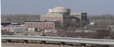
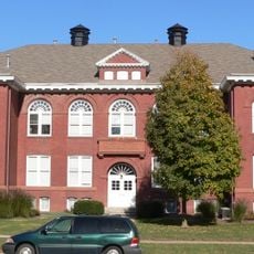
Fort Calhoun Nuclear Generating Station, former nuclear power plant in Washington County, Nebraska

The Fort Calhoun Nuclear Generating Station is a decommissioned nuclear power plant in Nebraska, located about 19 miles north of Omaha. The facility operated a pressurized water reactor with a capacity of approximately 478 megawatts and occupied about 660 acres of land.

Construction began in 1966 and the reactor started operating in 1973, providing about a quarter of the region's electricity for several decades. After economic considerations and safety concerns, the facility was permanently shut down in October 2016.

The site is currently closed to public visits as it is undergoing active decommissioning and decontamination work. Strict security measures and regulatory restrictions protect the area and surrounding communities during the dismantling process.

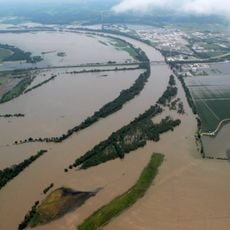
For many years, this was the smallest operating nuclear facility in North America with a single reactor unit. The site sits near the Missouri River, where severe flooding in 2011 caused a water-filled barrier to rupture, requiring emergency protective measures to keep the reactor safe.

The community of curious travelers

AroundUs brings together thousands of curated places, local tips, and hidden gems, enriched daily by 60,000 contributors worldwide.

Start exploring
Location
GPS coordinates
41.52030,-96.07720
Latest update
February 17, 2026 00:20
Around this place
Fort Atkinson
United States of America

Fort Atkinson

9.3 km
Fort Atkinson State Historical Park
United States of America

Fort Atkinson State Historical Park

9 km
Hummel Park
United States of America

Hummel Park

19.3 km
Fort Omaha
United States of America

Fort Omaha

25.8 km
DeSoto National Wildlife Refuge
United States of America

DeSoto National Wildlife Refuge

5 km
Malcolm X House
United States of America

Malcolm X House

27.3 km
Glenn Cunningham Lake
United States of America

Glenn Cunningham Lake

18.9 km
Florence Mill
United States of America

Florence Mill

21.9 km
General Crook House
United States of America

General Crook House

22.6 km
Bank of Florence Museum
United States of America

Bank of Florence Museum

22.6 km
Neale Woods
United States of America

Neale Woods

17.9 km
Ackerhurst Dairy Barn
United States of America

Ackerhurst Dairy Barn

21.4 km
Blair High School
United States of America

Blair High School

5.4 km
Blair Bridge
United States of America

Blair Bridge

3.8 km
Blair Bridge
United States of America

Blair Bridge

3.8 km
Benson City Hall
United States of America

Benson City Hall

26.8 km
Hitchcock Nature Center
United States of America

Hitchcock Nature Center

21.4 km
Henry B. Neef House
United States of America

Henry B. Neef House

24 km
Congregational Church of Blair
United States of America

Congregational Church of Blair

5.4 km
Washington County Courthouse
United States of America

Washington County Courthouse

5.3 km
Alfred H. and Sarah Frahm House
United States of America

Alfred H. and Sarah Frahm House

8.4 km
Abraham Castetter House
United States of America

Abraham Castetter House

5.7 km
C.C. Crowell Jr. House
United States of America

C.C. Crowell Jr. House

6.2 km
Neale Woods
United States of America

Neale Woods

17.6 km
Winter Quarters Mill Museum
United States of America

Winter Quarters Mill Museum

21.9 km
Florence Mill Museum
United States of America

Florence Mill Museum

21.9 km
Harrison County Historical Village & Iowa Welcome Center
United States of America

Harrison County Historical Village & Iowa Welcome Center

20.3 km
Notre Dame Academy and Convent
United States of America

Notre Dame Academy and Convent

22.6 km
Show the full map
Reviews
Share your experience

No review yet

Discussions
Start a discussion...

No discussion yet

« Fort Calhoun Nuclear Generating Station - former nuclear power plant in Washington County, Nebraska » is provided by Around Us (aroundus.com). Images and texts are derived from Wikimedia project under a Creative Commons license. You are allowed to copy, distribute, and modify copies of this page, under the conditions set by the license, as long as this note is clearly visible.

Discover hidden gems everywhere you go!

From secret cafés to breathtaking viewpoints, skip the crowded tourist spots and find places that match your style. Our app makes it easy with voice search, smart filtering, route optimization, and insider tips from travelers worldwide. Download now for the complete mobile experience.

Around Us App Screenshot

A unique approach to discovering new places

Le Figaro

All the places worth exploring

France Info

A tailor-made excursion in just a few clicks

20 Minutes

Around Us
Travel Guide & Maps
Download

Send to your phone

QR Code
1

Open the camera app on your mobile.

2

Point at the QR code with your camera. A notification will appear.

3

Tap the notification to open the link.