Chest opened
+${chestReward.xp} XP
Explorer
NOUVEAU ×${chestReward.collectible.quantity}
tapez pour fermer
Chest locked

Open chests in the app

Around Us is built for your phone — chests unlock when you walk, explore and capture nearby places.

Enable Location

We need your location to show you interesting places around you

Discover nearby places

Find interesting locations and hidden gems around you

Precise directions

Get accurate directions and distances to places

Your location is never shared with other users. It's only used when you tap the location button.

Log in to your account

Start exploring — it's free

Trusted by 72,891 travelers worldwide

Continue with Google
Continue with Apple
or

We will send you a code to connect

By continuing, you accept our Terms and Conditions and our Privacy Policy

Check your inbox

We've sent a pincode in your inbox. Please enter the code below.

Virginia Capes
Discussion Reviews Photo
7.3k Popularity

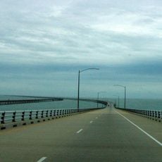
Virginia Capes, Coastal promontories at Chesapeake Bay entrance, United States.

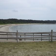
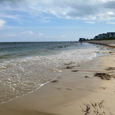
The Virginia Capes consist of two natural points of land that form the entrance to Chesapeake Bay on the Atlantic coast of North America. These geographical features create a distinctive gateway where the bay opens toward the ocean.

The area witnessed the Battle of the Chesapeake in 1781, a naval engagement that shaped the outcome of the American Revolutionary War. This battle prevented British forces from resupplying their troops in the region.

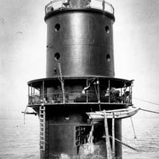
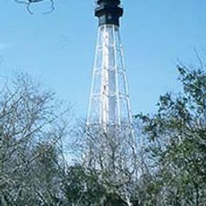
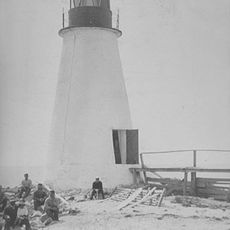
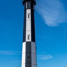
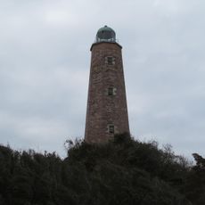
The Cape Henry Lighthouse, standing since the late 1700s, serves as a distinctive landmark that guides vessels and marks the gateway to the region.

The region is home to several military installations where regular training exercises and testing of naval vessels occur. Visitors should expect military activity and be aware that certain areas may have restricted access.

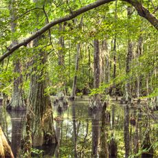
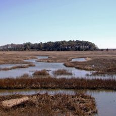
The waters surrounding the Virginia Capes contain diverse marine ecosystems with a wide range of ocean animals. This coastal area provides habitat for fish, marine mammals, and numerous bird species that gather to feed.

The community of curious travelers

AroundUs brings together thousands of curated places, local tips, and hidden gems, enriched daily by 60,000 contributors worldwide.

Start exploring
GPS coordinates
37.02889,-76.06806
Latest update
December 10, 2025 15:47
Around this place
Chesapeake Bay Bridge-Tunnel
United States of America

Chesapeake Bay Bridge-Tunnel

1.6 km
King Neptune
United States of America

King Neptune

20.5 km
First Landing State Park
United States of America

First Landing State Park

14.5 km
Cavalier Hotel
United States of America

Cavalier Hotel

19.3 km
Kiptopeke State Park
United States of America

Kiptopeke State Park

17.5 km
Adam Thoroughgood House
United States of America

Adam Thoroughgood House

15.6 km
Ferry Plantation House
United States of America

Ferry Plantation House

18.9 km
Norfolk Botanical Garden
United States of America

Norfolk Botanical Garden

18.6 km
Broad Bay Manor
United States of America

Broad Bay Manor

15.3 km
Thimble Shoal Light
United States of America

Thimble Shoal Light

15.4 km
Cape Henry Memorial
United States of America

Cape Henry Memorial

12.4 km
Brock Environmental Center
United States of America

Brock Environmental Center

14.2 km
Adam Keeling House
United States of America

Adam Keeling House

14.3 km
Cape Charles Light
United States of America

Cape Charles Light

17.8 km
Eastern Shore of Virginia National Wildlife Refuge
United States of America

Eastern Shore of Virginia National Wildlife Refuge

14.6 km
Lynnhaven House
United States of America

Lynnhaven House

18.3 km
Cinema Cafe Pembroke Meadows
United States of America

Cinema Cafe Pembroke Meadows

19.1 km
Back River Light
United States of America

Back River Light

19.1 km
Weblin House
United States of America

Weblin House

19.5 km
The Hermitage
United States of America

The Hermitage

16.3 km
Dr. John Miller-Masury House
United States of America

Dr. John Miller-Masury House

18.1 km
Shirley Hall
United States of America

Shirley Hall

18.1 km
Briarwood
United States of America

Briarwood

19.3 km
Green Hill
United States of America

Green Hill

14.5 km
Fisherman Island National Wildlife Refuge
United States of America

Fisherman Island National Wildlife Refuge

12.1 km
Cape Henry Light
United States of America

Cape Henry Light

12.6 km
Old Cape Henry Lighthouse
United States of America

Old Cape Henry Lighthouse

12.7 km
Salt Ponds Beach
United States of America

Salt Ponds Beach

19.3 km
Show the full map
Reviews
Share your experience

No review yet

Discussions
Start a discussion...

No discussion yet

« Virginia Capes - Coastal promontories at Chesapeake Bay entrance, United States » is provided by Around Us (aroundus.com). Images and texts are derived from Wikimedia project under a Creative Commons license. You are allowed to copy, distribute, and modify copies of this page, under the conditions set by the license, as long as this note is clearly visible.

Discover hidden gems everywhere you go!

From secret cafés to breathtaking viewpoints, skip the crowded tourist spots and find places that match your style. Our app makes it easy with voice search, smart filtering, route optimization, and insider tips from travelers worldwide. Download now for the complete mobile experience.

Around Us App Screenshot

A unique approach to discovering new places

Le Figaro

All the places worth exploring

France Info

A tailor-made excursion in just a few clicks

20 Minutes

Around Us
Travel Guide & Maps
Download

Send to your phone

QR Code
1

Open the camera app on your mobile.

2

Point at the QR code with your camera. A notification will appear.

3

Tap the notification to open the link.