Enable Location

We need your location to show you interesting places around you

Discover nearby places

Find interesting locations and hidden gems around you

Precise directions

Get accurate directions and distances to places

Your location is never shared with other users. It's only used when you tap the location button.

Log in to your account

Start exploring — it's free

Trusted by 61,550 travelers worldwide

Continue with Google
Continue with Apple
or

We will send you a code to connect

By continuing, you accept our Terms and Conditions and our Privacy Policy

Check your inbox

We've sent a pincode in your inbox. Please enter the code below.

Fort Seybert

Fort Seybert, Colonial fort in Pendleton County, United States.

Description

Fort Seybert was a German frontier outpost built in 1756 along the South Fork of the South Branch Potomac River in the Appalachian mountains of West Virginia. It consisted of a circular stockade with blockhouses and served as a defensive structure for the growing settlement in this remote mountain valley.

History

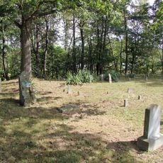
The fort was established in 1756 by German-speaking settlers to protect their farms in the border region. In April 1758 it was attacked and destroyed by Shawnee and Delaware warriors, marking a turning point in conflicts between settlers and indigenous peoples in this valley.

Culture

The site tells the story of early frontier settlements and shows how European colonists and Native Americans lived in close proximity in this mountain region. The remains speak to the tensions that shaped the valley's early years.

Practical

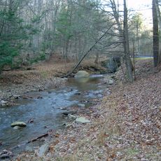
The site sits in a remote valley in the mountains and requires driving on rural roads through West Virginia. Visitors should be prepared for uneven terrain and be aware that the ruins are minimally marked with no formal pathways developed.

Did you know?

The fort was designed with a circular stockade about 30 meters in diameter and contained a two-story blockhouse inside as the central defensive structure. This compact defensive system was typical of colonial frontier forts and shows how settlers protected their settlements from attack.

GPS coordinates
38.69513,-79.19011
Latest update
December 11, 2025 18:02

AroundUs brings together thousands of curated places, local tips, and hidden gems, enriched daily by 60,000 contributors worldwide. Discover all places nearby (United States of America).

Around this place
Show the full map
« Fort Seybert - Colonial fort in Pendleton County, United States » is provided by Around Us (aroundus.com). Images and texts are derived from Wikimedia project under a Creative Commons license. You are allowed to copy, distribute, and modify copies of this page, under the conditions set by the license, as long as this note is clearly visible.

Discover hidden gems everywhere you go!

From secret cafés to breathtaking viewpoints, skip the crowded tourist spots and find places that match your style. Our app makes it easy with voice search, smart filtering, route optimization, and insider tips from travelers worldwide. Download now for the complete mobile experience.

Around Us App Screenshot

A unique approach to discovering new places

Le Figaro

All the places worth exploring

France Info

A tailor-made excursion in just a few clicks

20 Minutes

Around Us
Travel Guide & Maps
Download

Send to your phone

QR Code
1

Open the camera app on your mobile.

2

Point at the QR code with your camera. A notification will appear.

3

Tap the notification to open the link.