Enable Location

We need your location to show you interesting places around you

Discover nearby places

Find interesting locations and hidden gems around you

Precise directions

Get accurate directions and distances to places

Your location is never shared with other users. It's only used when you tap the location button.

Governor Robert McClelland House

Log in to your account

Start exploring — it's free

Trusted by 62,411 travelers worldwide

Continue with Google
Continue with Apple
or

We will send you a code to connect

By continuing, you accept our Terms and Conditions and our Privacy Policy

Check your inbox

We've sent a pincode in your inbox. Please enter the code below.

Governor Robert McClelland House

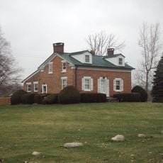
Governor Robert McClelland House, Historic residence in Monroe, Michigan.

The Governor Robert McClelland House is a residence in Monroe, Michigan, built in the Greek Revival style with symmetrical facades and prominent columns defining its front elevation. A western addition altered the original entrance placement and expanded the interior floor plan with additional rooms.

Built in 1841, the house served as the residence of Robert McClelland, who later became Michigan's governor and then served as Secretary of the Interior under President James K. Polk. Following his departure, merchant Benjamin Dansard acquired the property and held it within his family for several decades.

The property represents Michigan's early statehood period and became the first National Register of Historic Places listing in Monroe County in 1971.

The building sits on East Elm Avenue and contains several interior rooms including a library, bedroom, kitchen, and dining room across its spaces. Visitors can explore both the exterior architecture and interior layout to understand the full design of the property.

The property was registered as the first historic listing in Monroe County to the National Register of Historic Places in 1971, marking its importance to local heritage. This early recognition reflects how significant the building is to understanding Michigan's early development.

The community of curious travelers

AroundUs brings together thousands of curated places, local tips, and hidden gems, enriched daily by 60,000 contributors worldwide.

Start exploring
Location
Architectural style
Greek Revival architecture
GPS coordinates
41.91778,-83.39444
Latest update
December 14, 2025 16:43
Around this place
Maumee Bay State Park
United States of America

Maumee Bay State Park

26.1 km
Sterling State Park
United States of America

Sterling State Park

5 km
George Armstrong Custer Equestrian Monument
United States of America

George Armstrong Custer Equestrian Monument

191 m
Pointe Mouillee State Game Area
United States of America

Pointe Mouillee State Game Area

19.2 km
United States of America

Flat Rock Speedway

19.6 km
Toledo Harbor Light
United States of America

Toledo Harbor Light

18.2 km
Lake Erie Metropark
United States of America

Lake Erie Metropark

22.8 km
Detroit River Light
United States of America

Detroit River Light

22.9 km
Willow Metropark
United States of America

Willow Metropark

24.6 km
Old Village Historic District
United States of America

Old Village Historic District

746 m
Sawyer House
United States of America

Sawyer House

352 m
St. Mary's Church Complex Historic District
United States of America

St. Mary's Church Complex Historic District

222 m
Turtle Island Light
United States of America

Turtle Island Light

18.4 km
Huron High School
United States of America

Huron High School

23.3 km
St. Mary's Academy Historic District
United States of America

St. Mary's Academy Historic District

610 m
Edward Loranger House
United States of America

Edward Loranger House

2.4 km
Old Mill Museum
United States of America

Old Mill Museum

22.3 km
Saint Michael the Archangel Church
United States of America

Saint Michael the Archangel Church

858 m
Jefferson Avenue–Huron River and Harbin Drive–Silver Creek Canal Bridges
United States of America

Jefferson Avenue–Huron River and Harbin Drive–Silver Creek Canal Bridges

20.3 km
East Elm-North Macomb Street Historic District
United States of America

East Elm-North Macomb Street Historic District

264 m
Rudolph Nims House
United States of America

Rudolph Nims House

5.4 km
Gibraltar Road–Waterway Canal Bridge
United States of America

Gibraltar Road–Waterway Canal Bridge

26 km
Dundee Historic District
United States of America

Dundee Historic District

22.4 km
Wing–Allore House
United States of America

Wing–Allore House

119 m
Bridge School
United States of America

Bridge School

13.6 km
St. John's Lutheran Church and School
United States of America

St. John's Lutheran Church and School

20.1 km
North Maumee Bay Archeological District
United States of America

North Maumee Bay Archeological District

19.2 km
Navarre-Anderson Trading Post
United States of America

Navarre-Anderson Trading Post

5.7 km
Show the full map
« Governor Robert McClelland House - Historic residence in Monroe, Michigan » is provided by Around Us (aroundus.com). Images and texts are derived from Wikimedia project under a Creative Commons license. You are allowed to copy, distribute, and modify copies of this page, under the conditions set by the license, as long as this note is clearly visible.

Discover hidden gems everywhere you go!

From secret cafés to breathtaking viewpoints, skip the crowded tourist spots and find places that match your style. Our app makes it easy with voice search, smart filtering, route optimization, and insider tips from travelers worldwide. Download now for the complete mobile experience.

Around Us App Screenshot

A unique approach to discovering new places

Le Figaro

All the places worth exploring

France Info

A tailor-made excursion in just a few clicks

20 Minutes

Around Us
Travel Guide & Maps
Download

Send to your phone

QR Code
1

Open the camera app on your mobile.

2

Point at the QR code with your camera. A notification will appear.

3

Tap the notification to open the link.