Enable Location

We need your location to show you interesting places around you

Discover nearby places

Find interesting locations and hidden gems around you

Precise directions

Get accurate directions and distances to places

Your location is never shared with other users. It's only used when you tap the location button.

Sterling State Park

Log in to your account

Start exploring — it's free

Trusted by 62,384 travelers worldwide

Continue with Google
Continue with Apple
or

We will send you a code to connect

By continuing, you accept our Terms and Conditions and our Privacy Policy

Check your inbox

We've sent a pincode in your inbox. Please enter the code below.

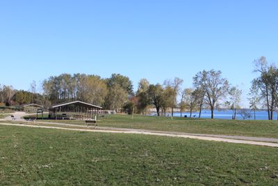
Sterling State Park, State park in Frenchtown Charter Township, Michigan, United States.

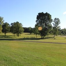
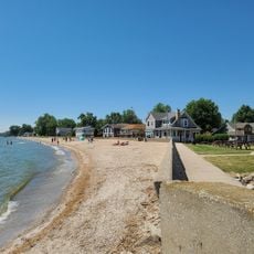
Sterling State Park is a nature reserve in Michigan on Lake Erie's shore, featuring marshlands, forests, and sandy beaches. The park spreads across a large area with different habitats that visitors can explore through trails.

The park was created in 1935 to protect the Lake Erie shoreline and provide recreation for local communities. Since then, it has played an important role in safeguarding the region's wetlands.

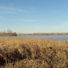
The park sits along a major bird migration route, and visitors can watch species traveling between North and South America. The wetlands and shoreline habitats support wildlife that has become scarce elsewhere in the region.

The park is located right on the water and offers boat launch ramps and fully equipped camping areas. Facilities are accessible, and day-use areas are available for visitors who prefer not to stay overnight.

This is Michigan's only state park situated directly on Lake Erie, making it a rare access point to this Great Lakes shoreline. Its location makes it especially important for protecting marsh habitats that have vanished elsewhere.

The community of curious travelers

AroundUs brings together thousands of curated places, local tips, and hidden gems, enriched daily by 60,000 contributors worldwide.

Start exploring
Location
Inception
1935
Address
State Park Road
GPS coordinates
41.91560,-83.33360
Latest update
December 8, 2025 19:57
Around this place
George Armstrong Custer Equestrian Monument
United States of America

George Armstrong Custer Equestrian Monument

5.2 km
Pointe Mouillee State Game Area
United States of America

Pointe Mouillee State Game Area

15.2 km
United States of America

Flat Rock Speedway

18.6 km
St. Mary Catholic Central High School
United States of America

St. Mary Catholic Central High School

5.3 km
Toledo Harbor Light
United States of America

Toledo Harbor Light

17.1 km
Lake Erie Metropark
United States of America

Lake Erie Metropark

20 km
Detroit River Light
United States of America

Detroit River Light

18.5 km
Willow Metropark
United States of America

Willow Metropark

25 km
Old Village Historic District
United States of America

Old Village Historic District

5.5 km
Sawyer House
United States of America

Sawyer House

4.9 km
St. Mary's Church Complex Historic District
United States of America

St. Mary's Church Complex Historic District

5.2 km
Turtle Island Light
United States of America

Turtle Island Light

18.8 km
Huron High School
United States of America

Huron High School

23.2 km
St. Mary's Academy Historic District
United States of America

St. Mary's Academy Historic District

4.6 km
Edward Loranger House
United States of America

Edward Loranger House

3.7 km
Saint Michael the Archangel Church
United States of America

Saint Michael the Archangel Church

5.9 km
Governor Robert McClelland House
United States of America

Governor Robert McClelland House

5 km
Jefferson Avenue–Huron River and Harbin Drive–Silver Creek Canal Bridges
United States of America

Jefferson Avenue–Huron River and Harbin Drive–Silver Creek Canal Bridges

17.2 km
East Elm-North Macomb Street Historic District
United States of America

East Elm-North Macomb Street Historic District

5 km
Monroe County Fairgrounds
United States of America

Monroe County Fairgrounds

10.7 km
Rudolph Nims House
United States of America

Rudolph Nims House

10.4 km
Gibraltar Road–Waterway Canal Bridge
United States of America

Gibraltar Road–Waterway Canal Bridge

23.2 km
Luna Pier Public Beach
United States of America

Luna Pier Public Beach

15 km
Wing–Allore House
United States of America

Wing–Allore House

4.9 km
Bridge School
United States of America

Bridge School

18.5 km
St. John's Lutheran Church and School
United States of America

St. John's Lutheran Church and School

20.8 km
North Maumee Bay Archeological District
United States of America

North Maumee Bay Archeological District

20.8 km
Navarre-Anderson Trading Post
United States of America

Navarre-Anderson Trading Post

10.7 km
Show the full map
« Sterling State Park - State park in Frenchtown Charter Township, Michigan, United States » is provided by Around Us (aroundus.com). Images and texts are derived from Wikimedia project under a Creative Commons license. You are allowed to copy, distribute, and modify copies of this page, under the conditions set by the license, as long as this note is clearly visible.

Discover hidden gems everywhere you go!

From secret cafés to breathtaking viewpoints, skip the crowded tourist spots and find places that match your style. Our app makes it easy with voice search, smart filtering, route optimization, and insider tips from travelers worldwide. Download now for the complete mobile experience.

Around Us App Screenshot

A unique approach to discovering new places

Le Figaro

All the places worth exploring

France Info

A tailor-made excursion in just a few clicks

20 Minutes

Around Us
Travel Guide & Maps
Download

Send to your phone

QR Code
1

Open the camera app on your mobile.

2

Point at the QR code with your camera. A notification will appear.

3

Tap the notification to open the link.