Enable Location

We need your location to show you interesting places around you

Discover nearby places

Find interesting locations and hidden gems around you

Precise directions

Get accurate directions and distances to places

Your location is never shared with other users. It's only used when you tap the location button.

George Armstrong Custer Equestrian Monument

Log in to your account

Start exploring — it's free

Trusted by 62,393 travelers worldwide

Continue with Google
Continue with Apple
or

We will send you a code to connect

By continuing, you accept our Terms and Conditions and our Privacy Policy

Check your inbox

We've sent a pincode in your inbox. Please enter the code below.

George Armstrong Custer Equestrian Monument

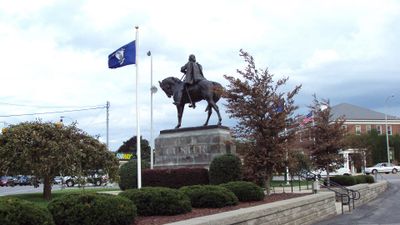
George Armstrong Custer Equestrian Monument, Bronze equestrian monument in Monroe, United States.

The George Armstrong Custer Equestrian Monument is a bronze statue in downtown Monroe showing the General in his Civil War uniform seated on a horse with all four hooves touching the ground. It stands at the intersection of Elm Avenue and North Monroe Street near the River Raisin.

The monument was unveiled in 1910 by President William Howard Taft and Elizabeth Bacon Custer to honor the General's military service during the Civil War. Sculptor Edward Clark Potter created the bronze work with architectural support from Hunt & Hunt.

The monument portrays a military figure from the region's past, dressed in period uniform astride a horse with hooves planted firmly on the ground. Visitors passing through downtown often pause here to consider the role this leader held in the area's history.

The monument stands at a street corner in downtown and is easy to locate and access on foot. The nearby river and open surroundings make it simple to visit and view the statue from different angles.

The statue was moved twice during its history: first in 1923 to Soldiers and Sailors Park and then in 1955 to its present location for better visibility. These relocations show how the city changed over time and how communities reconsidered where public monuments should stand.

The community of curious travelers

AroundUs brings together thousands of curated places, local tips, and hidden gems, enriched daily by 60,000 contributors worldwide.

Start exploring
Location
Inception
1910
Creator
Edward Clark Potter
GPS coordinates
41.91816,-83.39669
Latest update
December 8, 2025 19:58
Around this place
Sterling State Park
United States of America

Sterling State Park

5.2 km
Pointe Mouillee State Game Area
United States of America

Pointe Mouillee State Game Area

19.3 km
United States of America

Flat Rock Speedway

19.7 km
St. Mary Catholic Central High School
United States of America

St. Mary Catholic Central High School

150 m
Toledo Harbor Light
United States of America

Toledo Harbor Light

18.3 km
Lake Erie Metropark
United States of America

Lake Erie Metropark

22.9 km
Detroit River Light
United States of America

Detroit River Light

23.1 km
Old Village Historic District
United States of America

Old Village Historic District

687 m
Sawyer House
United States of America

Sawyer House

473 m
St. Mary's Church Complex Historic District
United States of America

St. Mary's Church Complex Historic District

81 m
Turtle Island Light
United States of America

Turtle Island Light

18.4 km
Huron High School
United States of America

Huron High School

23.3 km
St. Mary's Academy Historic District
United States of America

St. Mary's Academy Historic District

753 m
Edward Loranger House
United States of America

Edward Loranger House

2.5 km
Old Mill Museum
United States of America

Old Mill Museum

22.1 km
Saint Michael the Archangel Church
United States of America

Saint Michael the Archangel Church

672 m
Governor Robert McClelland House
United States of America

Governor Robert McClelland House

191 m
Jefferson Avenue–Huron River and Harbin Drive–Silver Creek Canal Bridges
United States of America

Jefferson Avenue–Huron River and Harbin Drive–Silver Creek Canal Bridges

20.4 km
East Elm-North Macomb Street Historic District
United States of America

East Elm-North Macomb Street Historic District

345 m
Monroe County Fairgrounds
United States of America

Monroe County Fairgrounds

5.6 km
Rudolph Nims House
United States of America

Rudolph Nims House

5.2 km
Dundee Historic District
United States of America

Dundee Historic District

22.3 km
Luna Pier Public Beach
United States of America

Luna Pier Public Beach

12.8 km
Wing–Allore House
United States of America

Wing–Allore House

310 m
Bridge School
United States of America

Bridge School

13.4 km
St. John's Lutheran Church and School
United States of America

St. John's Lutheran Church and School

20 km
North Maumee Bay Archeological District
United States of America

North Maumee Bay Archeological District

19.2 km
Navarre-Anderson Trading Post
United States of America

Navarre-Anderson Trading Post

5.5 km
Show the full map
« George Armstrong Custer Equestrian Monument - Bronze equestrian monument in Monroe, United States » is provided by Around Us (aroundus.com). Images and texts are derived from Wikimedia project under a Creative Commons license. You are allowed to copy, distribute, and modify copies of this page, under the conditions set by the license, as long as this note is clearly visible.

Discover hidden gems everywhere you go!

From secret cafés to breathtaking viewpoints, skip the crowded tourist spots and find places that match your style. Our app makes it easy with voice search, smart filtering, route optimization, and insider tips from travelers worldwide. Download now for the complete mobile experience.

Around Us App Screenshot

A unique approach to discovering new places

Le Figaro

All the places worth exploring

France Info

A tailor-made excursion in just a few clicks

20 Minutes

Around Us
Travel Guide & Maps
Download

Send to your phone

QR Code
1

Open the camera app on your mobile.

2

Point at the QR code with your camera. A notification will appear.

3

Tap the notification to open the link.