Enable Location

We need your location to show you interesting places around you

Discover nearby places

Find interesting locations and hidden gems around you

Precise directions

Get accurate directions and distances to places

Your location is never shared with other users. It's only used when you tap the location button.

Wing–Allore House

Log in to your account

Start exploring — it's free

Trusted by 62,392 travelers worldwide

Continue with Google
Continue with Apple
or

We will send you a code to connect

By continuing, you accept our Terms and Conditions and our Privacy Policy

Check your inbox

We've sent a pincode in your inbox. Please enter the code below.

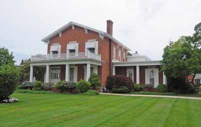
Wing–Allore House, historic house in Michigan, United States

The Wing-Allore House is a two-story Italianate building with red brick walls and a distinctive gable front on East Elm Avenue in Monroe. Over time, wings and additions were added to it, including nineteen decorative brackets in the 1850s, and the structure was later adapted to serve as a funeral home.

The building was constructed between 1829 and 1831 and initially served as a private home for prominent citizens like Sheriff and Congressional delegate Austin E. Wing. Its architecture was significantly altered in the 1850s and 1860s, reflecting changes in local building styles during that period.

The house was home to Austin E. Wing, an early local leader, and later his son Talcott E. Wing, who documented Monroe County's history. These families shaped how the town remembers its past.

The house is located on East Elm Avenue and is visible from the street as part of an active funeral home operation. Visitors can view the exterior and architectural details from the sidewalk, though keep in mind the interior remains in active use for funeral services.

Since 1938, the house has operated continuously as a funeral home, making it the longest-running such operation in the area. This enduring function shows how historic buildings can transform their purpose while preserving their original structure.

The community of curious travelers

AroundUs brings together thousands of curated places, local tips, and hidden gems, enriched daily by 60,000 contributors worldwide.

Start exploring
Location
Inception
1829
Architectural style
Italianate architecture
Address
203 East Elm Avenue
GPS coordinates
41.91750,-83.39306
Latest update
February 9, 2026 07:43
Around this place
Maumee Bay State Park
United States of America

Maumee Bay State Park

26.1 km
Sterling State Park
United States of America

Sterling State Park

4.9 km
George Armstrong Custer Equestrian Monument
United States of America

George Armstrong Custer Equestrian Monument

310 m
Pointe Mouillee State Game Area
United States of America

Pointe Mouillee State Game Area

19.1 km
United States of America

Flat Rock Speedway

19.6 km
Toledo Harbor Light
United States of America

Toledo Harbor Light

18.1 km
Lake Erie Metropark
United States of America

Lake Erie Metropark

22.8 km
Detroit River Light
United States of America

Detroit River Light

22.8 km
Willow Metropark
United States of America

Willow Metropark

24.6 km
Old Village Historic District
United States of America

Old Village Historic District

800 m
Sawyer House
United States of America

Sawyer House

310 m
St. Mary's Church Complex Historic District
United States of America

St. Mary's Church Complex Historic District

337 m
Turtle Island Light
United States of America

Turtle Island Light

18.4 km
Huron High School
United States of America

Huron High School

23.3 km
St. Mary's Academy Historic District
United States of America

St. Mary's Academy Historic District

539 m
Edward Loranger House
United States of America

Edward Loranger House

2.3 km
Old Mill Museum
United States of America

Old Mill Museum

22.4 km
Saint Michael the Archangel Church
United States of America

Saint Michael the Archangel Church

974 m
Governor Robert McClelland House
United States of America

Governor Robert McClelland House

119 m
Jefferson Avenue–Huron River and Harbin Drive–Silver Creek Canal Bridges
United States of America

Jefferson Avenue–Huron River and Harbin Drive–Silver Creek Canal Bridges

20.3 km
East Elm-North Macomb Street Historic District
United States of America

East Elm-North Macomb Street Historic District

279 m
Rudolph Nims House
United States of America

Rudolph Nims House

5.5 km
Gibraltar Road–Waterway Canal Bridge
United States of America

Gibraltar Road–Waterway Canal Bridge

25.9 km
Dundee Historic District
United States of America

Dundee Historic District

22.6 km
Bridge School
United States of America

Bridge School

13.8 km
St. John's Lutheran Church and School
United States of America

St. John's Lutheran Church and School

20.1 km
North Maumee Bay Archeological District
United States of America

North Maumee Bay Archeological District

19.2 km
Navarre-Anderson Trading Post
United States of America

Navarre-Anderson Trading Post

5.8 km
Show the full map
« Wing–Allore House - historic house in Michigan, United States » is provided by Around Us (aroundus.com). Images and texts are derived from Wikimedia project under a Creative Commons license. You are allowed to copy, distribute, and modify copies of this page, under the conditions set by the license, as long as this note is clearly visible.

Discover hidden gems everywhere you go!

From secret cafés to breathtaking viewpoints, skip the crowded tourist spots and find places that match your style. Our app makes it easy with voice search, smart filtering, route optimization, and insider tips from travelers worldwide. Download now for the complete mobile experience.

Around Us App Screenshot

A unique approach to discovering new places

Le Figaro

All the places worth exploring

France Info

A tailor-made excursion in just a few clicks

20 Minutes

Around Us
Travel Guide & Maps
Download

Send to your phone

QR Code
1

Open the camera app on your mobile.

2

Point at the QR code with your camera. A notification will appear.

3

Tap the notification to open the link.