Enable Location

We need your location to show you interesting places around you

Discover nearby places

Find interesting locations and hidden gems around you

Precise directions

Get accurate directions and distances to places

Your location is never shared with other users. It's only used when you tap the location button.

Hains Point

Log in to your account

Start exploring — it's free

Trusted by 61,677 travelers worldwide

Continue with Google
Continue with Apple
or

We will send you a code to connect

By continuing, you accept our Terms and Conditions and our Privacy Policy

Check your inbox

We've sent a pincode in your inbox. Please enter the code below.

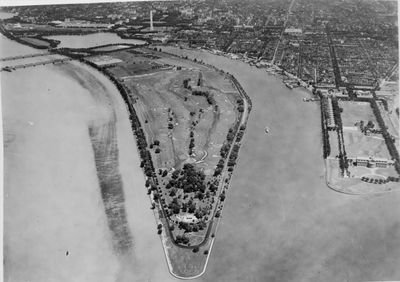
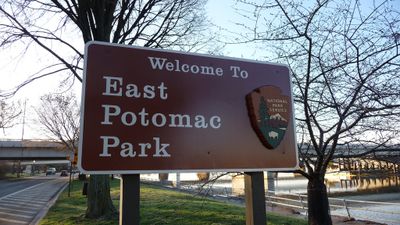
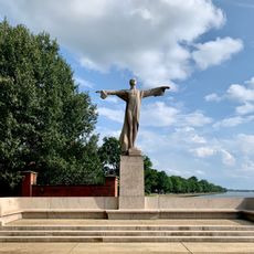
Hains Point, Urban park and fishing spot in East Potomac Park, United States

Description

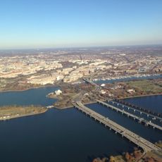
Hains Point is an urban park at the southern tip of East Potomac Park, surrounded by three waterways: the Potomac River, Washington Channel, and Anacostia River. The land itself was built up from river dredging and now forms a peninsula with open green spaces, walking paths, and water views.

History

The peninsula was created between 1880 and 1892 through an engineering project that used dredged material from the Potomac River to build new land. This artificially formed area was later developed into a public park.

Culture

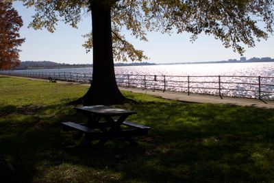
The open spaces here serve as a gathering place where people fish from the shore, walk along the water, and enjoy the river views at their own pace. Locals often stop by to feed birds, rest on benches, and watch the boats passing through the channels.

Practical

The park has four designated picnic areas where visitors can bring their own food and spend time outdoors with others. Alcohol and glass containers are prohibited, and certain activities like ball sports are restricted.

Did you know?

A 5-kilometer-long road loops around the entire peninsula and closes to vehicles on weekends, creating room for cyclists and skaters to enjoy the space. Hundreds of cherry trees line the grounds, creating a pink bloom display in spring.

Location
Inception
1882
Official opening
1890
Part of
East Potomac Park
Address
1100 Ohio Dr SW, Washington DC 20242-0001
GPS coordinates
38.85917,-77.02278
Latest update
December 7, 2025 20:47

AroundUs brings together thousands of curated places, local tips, and hidden gems, enriched daily by 60,000 contributors worldwide. Discover all places nearby (Washington, D.C.).

Around this place
USS Sequoia
United States of America

USS Sequoia

1.8 km
The Anthem
United States of America

The Anthem

2.3 km
Titanic Memorial
United States of America

Titanic Memorial

1.5 km
Barry Farm
United States of America

Barry Farm

2.2 km
14th Street Bridges
United States of America

14th Street Bridges

2.3 km
Buzzard Point
United States of America

Buzzard Point

1.4 km
Douglas A. Munro Coast Guard Headquarters Building
United States of America

Douglas A. Munro Coast Guard Headquarters Building

1.8 km
The Wharf
United States of America

The Wharf

2.3 km
East Potomac Park
United States of America

East Potomac Park

1.2 km
Frederick Douglass Memorial Bridge
United States of America

Frederick Douglass Memorial Bridge

1.8 km
Roosevelt Hall
United States of America

Roosevelt Hall

665 m
Thomas Law House
United States of America

Thomas Law House

1.9 km
Fort Jackson
United States of America

Fort Jackson

2.1 km
Ohio Drive SW
United States of America

Ohio Drive SW

2.3 km
Long Bridge
United States of America

Long Bridge

2.2 km
Wheat Row
United States of America

Wheat Row

1.7 km
United States of America

Waterfront Tower

2.1 km
James C. Dent House
United States of America

James C. Dent House

1.5 km
Southwest Neighborhood Library
United States of America

Southwest Neighborhood Library

2.3 km
Tiber Island Cooperative Homes
United States of America

Tiber Island Cooperative Homes

1.8 km
District of Columbia Main Sewerage Pumping Station
United States of America

District of Columbia Main Sewerage Pumping Station

2.4 km
Duncanson-Cranch House
United States of America

Duncanson-Cranch House

1.8 km
Edward Simon Lewis House
United States of America

Edward Simon Lewis House

1.8 km
Culture House DC
United States of America

Culture House DC

2.4 km
Buzzard Point Power Plant
United States of America

Buzzard Point Power Plant

1.2 km
Mead Center for American Theater
United States of America

Mead Center for American Theater

2 km
Maine Lobsterman Memorial
United States of America

Maine Lobsterman Memorial

2 km
National Capital Parks Headquarters
United States of America

National Capital Parks Headquarters

2.1 km
Show the full map
« Hains Point - Urban park and fishing spot in East Potomac Park, United States » is provided by Around Us (aroundus.com). Images and texts are derived from Wikimedia project under a Creative Commons license. You are allowed to copy, distribute, and modify copies of this page, under the conditions set by the license, as long as this note is clearly visible.

Discover hidden gems everywhere you go!

From secret cafés to breathtaking viewpoints, skip the crowded tourist spots and find places that match your style. Our app makes it easy with voice search, smart filtering, route optimization, and insider tips from travelers worldwide. Download now for the complete mobile experience.

Around Us App Screenshot

A unique approach to discovering new places

Le Figaro

All the places worth exploring

France Info

A tailor-made excursion in just a few clicks

20 Minutes

Around Us
Travel Guide & Maps
Download

Send to your phone

QR Code
1

Open the camera app on your mobile.

2

Point at the QR code with your camera. A notification will appear.

3

Tap the notification to open the link.