Log in to your account

AroundUs is a community-driven map of interesting places, built by curious explorers like you. It grows with every review, story, and photo you share.
Connect to save your favorite spots, contribute locations, and create personalized routes.
Continue with Google
Continue with Apple
Continue with X
Continue with Facebook
Continue with email
By continuing, you accept our Terms and Conditions and our Privacy Policy
Create an account
Add to collection
Map
Suggest a change
Share

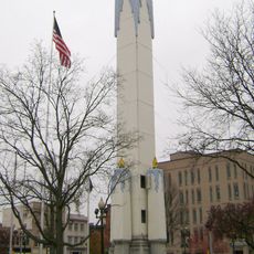
Indian Tower, Observation tower in Nazareth, United States.

Indian Tower is an observation tower in Nazareth, Pennsylvania, standing on the highest elevation of a former large property in the eastern region. The structure offers views across the surrounding landscape and currently functions as a repeater station for emergency services.

The tower was built in 1916, replacing a summer house that stood on the same site since 1867. John Jordan Jr. supported its construction through a contribution to the Moravian Historical Society.

The name comes from the adjacent Moravian Graveyard, where four members of the Welagamika village were buried between 1744 and 1762. These graves remain an important part of the site and shape how locals understand its significance.

Visitors can climb the tower to take in views of the surrounding region, with conditions being most accessible in clear weather. Daytime visits offer the best visibility for enjoying the landscape views.

During World War II, the tower served as a civil defense observation post, monitoring the skies over Pennsylvania. This wartime role shows how the structure played a practical part in American history.

Location: Nazareth

GPS coordinates: 40.74730,-75.32320

Latest update: December 13, 2025 12:23

Photos
Around this place
Nazareth Speedway
United States of America

Nazareth Speedway

2.3 km
Bushkill Park
United States of America

Bushkill Park

7.9 km
Delaware Division of the Pennsylvania Canal
United States of America

Delaware Division of the Pennsylvania Canal

12 km
Peace Candle
United States of America

Peace Candle

11.5 km
Jacobsburg Environmental Education Center
United States of America

Jacobsburg Environmental Education Center

4.8 km
Fisher Stadium
United States of America

Fisher Stadium

10.8 km
Easton–Phillipsburg Toll Bridge
United States of America

Easton–Phillipsburg Toll Bridge

11.7 km
State Theatre
United States of America

State Theatre

11.2 km
Easton Area Public Library
United States of America

Easton Area Public Library

11.1 km
College Hill Residential Historic District
United States of America

College Hill Residential Historic District

11.1 km
Whitefield House and Gray Cottage
United States of America

Whitefield House and Gray Cottage

1.5 km
Zeta Psi Fraternity House
United States of America

Zeta Psi Fraternity House

11.2 km
United States of America

Nurture Nature Center

11.2 km
Easton House
United States of America

Easton House

11.6 km
Lee and Virginia Graver Arboretum
United States of America

Lee and Virginia Graver Arboretum

6.8 km
Parsons-Taylor House
United States of America

Parsons-Taylor House

11.5 km
Easton Historic District
United States of America

Easton Historic District

11.3 km
Phillipsburg Commercial Historic District
United States of America

Phillipsburg Commercial Historic District

12 km
Jacob Nicholas House
United States of America

Jacob Nicholas House

11.3 km
William Jacob Heller House
United States of America

William Jacob Heller House

11.4 km
Daniel Steckel House
United States of America

Daniel Steckel House

6.4 km
Holy Ghost Ukrainian Catholic Church
United States of America

Holy Ghost Ukrainian Catholic Church

10.7 km
McCollum and Post Silk Mill
United States of America

McCollum and Post Silk Mill

972 m
Northampton Street Bridge
United States of America

Northampton Street Bridge

11.8 km
Karl Stirner Arts Trail
United States of America

Karl Stirner Arts Trail

10.3 km
Nazareth Historic District
United States of America

Nazareth Historic District

1.2 km
Nazareth Hall Tract
United States of America

Nazareth Hall Tract

763 m
Lehigh and Hudson River Railway Bridge
United States of America

Lehigh and Hudson River Railway Bridge

12 km
Show the full map
Reviews

Visited this place? Tap the stars to rate it and share your experience / photos with the community! Try now! You can cancel it anytime.

« Indian Tower - Observation tower in Nazareth, United States » is provided by Around Us (aroundus.com). Images and texts are derived from Wikimedia project under a Creative Commons license. You are allowed to copy, distribute, and modify copies of this page, under the conditions set by the license, as long as this note is clearly visible.

Discover hidden gems everywhere you go!

From secret cafés to breathtaking viewpoints, skip the crowded tourist spots and find places that match your style. Our app makes it easy with voice search, smart filtering, route optimization, and insider tips from travelers worldwide. Download now for the complete mobile experience.

Around Us App Screenshot

A unique approach to discovering new places

Le Figaro

All the places worth exploring

France Info

A tailor-made excursion in just a few clicks

20 Minutes