John T. Myers Locks and Dam

Log in to your account

AroundUs is a community-driven map of interesting places, built by curious explorers like you. It grows with every review, story, and photo you share.
Connect to save your favorite spots, contribute locations, and create personalized routes.
By continuing, you accept our Terms and Conditions and our Privacy Policy

John T. Myers Locks and Dam

Add to collection
Map
Suggest a change
Share

John T. Myers Locks and Dam, Navigation complex on the Ohio River between Indiana and Kentucky, United States
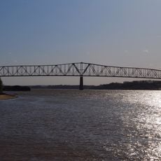
The John T. Myers Locks and Dam spans 3,504 feet across the Ohio River, featuring two locks of different sizes for commercial and recreational vessels.

Construction of the facility began in 1965 and completed in 1977, replacing the previous Locks and Dam 48 and 49 under the Rivers and Harbors Act.

The facility received its current name in 1996 through an act of Congress, honoring Congressman John T. Myers who served western Indiana for 30 years.

The main lock measures 1,200 feet by 110 feet while the auxiliary lock spans 600 feet by 110 feet, accommodating various vessel sizes on the Ohio River.

Located at river mile 846 from Pittsburgh, the facility manages water levels through a gravity dam system and dual-lock configuration for continuous navigation.

Location: Kentucky

Location: Indiana

GPS coordinates: 37.79350,-87.99090

Latest update: March 7, 2025 06:55

Around this place
Show the full map
Crenshaw House
United States of America

Crenshaw House

27.5 km
Illinois Salines
United States of America

Illinois Salines

28.5 km
Shawneetown Bank State Historic Site
United States of America

Shawneetown Bank State Historic Site

16.7 km
Mann Site
United States of America

Mann Site

18.8 km
Wabash Memorial Bridge
United States of America

Wabash Memorial Bridge

17.2 km
Shawneetown Bridge
United States of America

Shawneetown Bridge

16.8 km
Welborn Village Archeological Site
United States of America

Welborn Village Archeological Site

221 m
Hovey Lake Archaeological District
United States of America

Hovey Lake Archaeological District

7.4 km
Hubele Mounds and Village Site
United States of America

Hubele Mounds and Village Site

25.1 km
Ashworth Archaeological Site
United States of America

Ashworth Archaeological Site

7.9 km
Gallatin County Courthouse
United States of America

Gallatin County Courthouse

19.2 km
Hovey Lake Fish and Wildlife Area
United States of America

Hovey Lake Fish and Wildlife Area

5.7 km
Wilson Mounds and Village Site
United States of America

Wilson Mounds and Village Site

23.2 km
John Marshall House Museum
United States of America

John Marshall House Museum

16.9 km
Confederate Monument of Morganfield
United States of America

Confederate Monument of Morganfield

13 km
Posey County Courthouse Square
United States of America

Posey County Courthouse Square

17.6 km
Union County Courthouse
United States of America

Union County Courthouse

13.8 km
Camp Breckinridge Non-Commissioned Officers' Club
United States of America

Camp Breckinridge Non-Commissioned Officers' Club

15.7 km
Bieker-Wilson Village Site
United States of America

Bieker-Wilson Village Site

15.7 km
Duffy Site
United States of America

Duffy Site

11.8 km
I.O.O.F. and Barker Buildings
United States of America

I.O.O.F. and Barker Buildings

17.6 km
Mount Vernon Downtown Historic District
United States of America

Mount Vernon Downtown Historic District

17.4 km
Daniel H. Hughes House
United States of America

Daniel H. Hughes House

13.8 km
George N. Proctor House
United States of America

George N. Proctor House

15.7 km
Welborn Historic District
United States of America

Welborn Historic District

17.8 km
William Gonnerman House
United States of America

William Gonnerman House

17 km
Robert and John McKee Peeples Houses
United States of America

Robert and John McKee Peeples Houses

16.5 km
Morganfield Commercial District
United States of America

Morganfield Commercial District

13.8 km
Show the full map

Reviews

Visited this place? Tap the stars to rate it and share your experience / photos with the community! Try now! You can cancel it anytime.

« John T. Myers Locks and Dam - Navigation complex on the Ohio River between Indiana and Kentucky, United States » is provided by Around Us (aroundus.com). Images and texts are derived from Wikimedia project under a Creative Commons license. You are allowed to copy, distribute, and modify copies of this page, under the conditions set by the license, as long as this note is clearly visible.

Discover hidden gems everywhere you go!

From secret cafés to breathtaking viewpoints, skip the crowded tourist spots and find places that match your style. Our app makes it easy with voice search, smart filtering, route optimization, and insider tips from travelers worldwide. Download now for the complete mobile experience.

Around Us App Screenshot

A unique approach to discovering new places

Le Figaro

All the places worth exploring

France Info

A tailor-made excursion in just a few clicks

20 Minutes