Shawneetown Bridge

Log in to your account

AroundUs is a community-driven map of interesting places, built by curious explorers like you. It grows with every review, story, and photo you share.
Connect to save your favorite spots, contribute locations, and create personalized routes.
Continue with Google
Continue with Apple
Continue with X
Continue with Facebook
Continue with email
By continuing, you accept our Terms and Conditions and our Privacy Policy
Create an account
Add to collection
Map
Suggest a change
Share

Shawneetown Bridge, River crossing between Kentucky and Illinois, United States

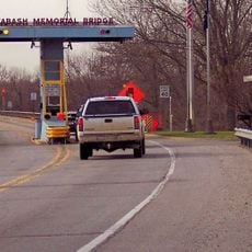
Shawneetown Bridge is a road bridge that carries Kentucky Route 56 and Illinois Route 13 across the Ohio River, connecting the two states with a substantial span. The structure features a cantilevered truss design that supports traffic crossing between the two banks.

The bridge opened in 1955, named after a Kentucky governor and U.S. Senator whose political support enabled its construction. Its opening filled a long-standing need for a major highway crossing over the Ohio River in this region.

The bridge appeared in the 1998 film U.S. Marshals, though the actual crash scene took place several miles downstream in Pope County.

The bridge serves as the primary highway connection between the two states in this remote section of the river. It is straightforward to cross on foot or by vehicle, with standard road conditions and clear markings.

A ferry service resumed operations in 2015 when the bridge underwent deck rehabilitation, specifically to assist farmers transporting equipment across the river.

Location: Kentucky

Location: Illinois

Inception: 1955

Official opening: 1955

GPS coordinates: 37.69110,-88.13140

Latest update: December 13, 2025 17:00

Photos
Around this place
Crenshaw House
United States of America

Crenshaw House

14.8 km
Garden of the Gods Wilderness
United States of America

Garden of the Gods Wilderness

25 km
Cave-in-Rock State Park
United States of America

Cave-in-Rock State Park

24.9 km
Illinois Salines
United States of America

Illinois Salines

14.5 km
United States of America

Tolu Site

30.2 km
Shawneetown Bank State Historic Site
United States of America

Shawneetown Bank State Historic Site

708 m
Illinois Iron Furnace
United States of America

Illinois Iron Furnace

27.5 km
John T. Myers Locks and Dam
United States of America

John T. Myers Locks and Dam

16.8 km
Wabash Memorial Bridge
United States of America

Wabash Memorial Bridge

29.4 km
United States of America

Welborn Village Archeological Site

17 km
Hovey Lake Archaeological District
United States of America

Hovey Lake Archaeological District

24.2 km
Battery Rock
United States of America

Battery Rock

18.5 km
Ashworth Archaeological Site
United States of America

Ashworth Archaeological Site

24.7 km
United States of America

Gallatin County Courthouse

5.6 km
Hovey Lake Fish and Wildlife Area
United States of America

Hovey Lake Fish and Wildlife Area

22.3 km
John Marshall House Museum
United States of America

John Marshall House Museum

560 m
Confederate Monument of Morganfield
United States of America

Confederate Monument of Morganfield

19.3 km
Union County Courthouse
United States of America

Union County Courthouse

18.9 km
Camp Breckinridge Non-Commissioned Officers' Club
United States of America

Camp Breckinridge Non-Commissioned Officers' Club

21.4 km
Bieker-Wilson Village Site
United States of America

Bieker-Wilson Village Site

25.6 km
Duffy Site
United States of America

Duffy Site

18.9 km
Daniel H. Hughes House
United States of America

Daniel H. Hughes House

18.8 km
George N. Proctor House
United States of America

George N. Proctor House

26.1 km
Robert and John McKee Peeples Houses
United States of America

Robert and John McKee Peeples Houses

810 m
Cave In Rock State Park
United States of America

Cave In Rock State Park

24.7 km
Morganfield Commercial District
United States of America

Morganfield Commercial District

18.9 km
Grand Theater
United States of America

Grand Theater

30.1 km
Peters Creek Lookout Tower
United States of America

Peters Creek Lookout Tower

21.8 km
Show the full map
Reviews

Visited this place? Tap the stars to rate it and share your experience / photos with the community! Try now! You can cancel it anytime.

« Shawneetown Bridge - River crossing between Kentucky and Illinois, United States » is provided by Around Us (aroundus.com). Images and texts are derived from Wikimedia project under a Creative Commons license. You are allowed to copy, distribute, and modify copies of this page, under the conditions set by the license, as long as this note is clearly visible.

Discover hidden gems everywhere you go!

From secret cafés to breathtaking viewpoints, skip the crowded tourist spots and find places that match your style. Our app makes it easy with voice search, smart filtering, route optimization, and insider tips from travelers worldwide. Download now for the complete mobile experience.

Around Us App Screenshot

A unique approach to discovering new places

Le Figaro

All the places worth exploring

France Info

A tailor-made excursion in just a few clicks

20 Minutes