Enable Location

We need your location to show you interesting places around you

Discover nearby places

Find interesting locations and hidden gems around you

Precise directions

Get accurate directions and distances to places

Your location is never shared with other users. It's only used when you tap the location button.

Cave-in-Rock State Park

Log in to your account

Start exploring — it's free

Trusted by 62,173 travelers worldwide

Continue with Google
Continue with Apple
or

We will send you a code to connect

By continuing, you accept our Terms and Conditions and our Privacy Policy

Check your inbox

We've sent a pincode in your inbox. Please enter the code below.

Cave-in-Rock State Park, State park and cave system in Hardin County, United States

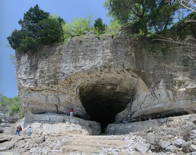
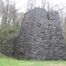
Cave-in-Rock State Park encompasses a natural limestone cave system situated along the Ohio River. The cave was shaped by water flow and geological forces across millennia, featuring multiple entrances and interconnected chambers.

French explorers documented the cave in the early 1700s, and it later became notorious as a hideout for river pirates. This phase of lawlessness faded as settlement increased and law enforcement reached the region.

The cave served as a refuge for river criminals for many years before becoming a gathering place for the local community. Visitors can still sense this layered past as they move through the natural chambers.

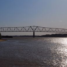
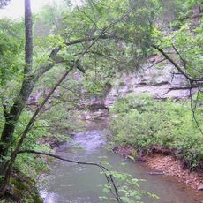
The park offers walking trails of varying difficulty with views toward the river and surrounding woodland. Wear sturdy footwear and be aware that the cave interior remains cool and can be slippery in places.

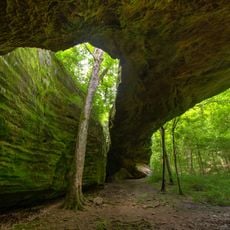
A striking natural opening at the top of the cave allows daylight to filter through, creating changing effects as the sun moves. This vertical passage reveals how the cave was sculpted by water and stone over deep time.

The community of curious travelers

AroundUs brings together thousands of curated places, local tips, and hidden gems, enriched daily by 60,000 contributors worldwide.

Start exploring
Location
Inception
1929
GPS coordinates
37.46861,-88.15583
Latest update
December 6, 2025 16:03
Historic and natural sites in Illinois

Illinois holds a rich collection of historical sites and natural landscapes. Visitors can explore prehistoric ruins like the Cahokia Mounds, where earthen structures reflect the achievements of ancient peoples. The region also features striking rock formations such as Garden of the Gods and natural...

Around this place
Crenshaw House
United States of America

Crenshaw House

31.5 km
Garden of the Gods Wilderness
United States of America

Garden of the Gods Wilderness

26.1 km
Illinois Salines
United States of America

Illinois Salines

29 km
United States of America

Tolu Site

9.2 km
Shawneetown Bank State Historic Site
United States of America

Shawneetown Bank State Historic Site

25.5 km
Illinois Iron Furnace
United States of America

Illinois Iron Furnace

15.6 km
John T. Myers Locks and Dam
United States of America

John T. Myers Locks and Dam

39 km
Shawneetown Bridge
United States of America

Shawneetown Bridge

24.9 km
Battery Rock
United States of America

Battery Rock

9.5 km
Mantle Rock Archeological District
United States of America

Mantle Rock Archeological District

27.3 km
Orr-Herl Mound and Village Site
United States of America

Orr-Herl Mound and Village Site

15.6 km
Golconda Historic District
United States of America

Golconda Historic District

31.4 km
United States of America

Gallatin County Courthouse

27.8 km
United States of America

Lusk's Ferry, Illinois

31.1 km
John Marshall House Museum
United States of America

John Marshall House Museum

25.2 km
Lusk Creek Canyon
United States of America

Lusk Creek Canyon

34.4 km
Confederate Monument of Morganfield
United States of America

Confederate Monument of Morganfield

33 km
Union County Courthouse
United States of America

Union County Courthouse

31.9 km
Hardin County Courthouse
United States of America

Hardin County Courthouse

13.4 km
Camp Breckinridge Non-Commissioned Officers' Club
United States of America

Camp Breckinridge Non-Commissioned Officers' Club

33.1 km
Fredonia Cumberland Presbyterian Church
United States of America

Fredonia Cumberland Presbyterian Church

30.1 km
Camp Mather-Camp Logan
United States of America

Camp Mather-Camp Logan

26.6 km
Daniel H. Hughes House
United States of America

Daniel H. Hughes House

31.8 km
Robert and John McKee Peeples Houses
United States of America

Robert and John McKee Peeples Houses

25.6 km
Providence Commercial Historic District
United States of America

Providence Commercial Historic District

35.6 km
Cave In Rock State Park
United States of America

Cave In Rock State Park

316 m
Morganfield Commercial District
United States of America

Morganfield Commercial District

31.9 km
Peters Creek Lookout Tower
United States of America

Peters Creek Lookout Tower

8.8 km
Show the full map
« Cave-in-Rock State Park - State park and cave system in Hardin County, United States » is provided by Around Us (aroundus.com). Images and texts are derived from Wikimedia project under a Creative Commons license. You are allowed to copy, distribute, and modify copies of this page, under the conditions set by the license, as long as this note is clearly visible.

Discover hidden gems everywhere you go!

From secret cafés to breathtaking viewpoints, skip the crowded tourist spots and find places that match your style. Our app makes it easy with voice search, smart filtering, route optimization, and insider tips from travelers worldwide. Download now for the complete mobile experience.

Around Us App Screenshot

A unique approach to discovering new places

Le Figaro

All the places worth exploring

France Info

A tailor-made excursion in just a few clicks

20 Minutes

Around Us
Travel Guide & Maps
Download

Send to your phone

QR Code
1

Open the camera app on your mobile.

2

Point at the QR code with your camera. A notification will appear.

3

Tap the notification to open the link.