·

Enable Location

We need your location to show you interesting places around you

Discover nearby places

Find interesting locations and hidden gems around you

Precise directions

Get accurate directions and distances to places

Your location is never shared with other users. It's only used when you tap the location button.

Kentucky & Indiana Terminal Bridge

Log in to your account

Start exploring — it's free

Trusted by 62,639 travelers worldwide

Continue with Google
Continue with Apple
or

We will send you a code to connect

By continuing, you accept our Terms and Conditions and our Privacy Policy

Check your inbox

We've sent a pincode in your inbox. Please enter the code below.

Kentucky & Indiana Terminal Bridge

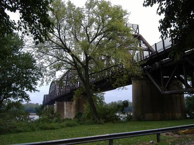
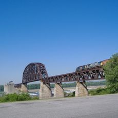
Kentucky & Indiana Terminal Bridge, Railway bridge in Louisville, US

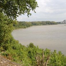
The Kentucky & Indiana Terminal Bridge is a railway crossing that spans the Ohio River between Louisville, Kentucky and New Albany, Indiana. The structure was built to handle both train traffic and vehicle transport, though its design reflects the transportation needs of the 19th century.

Construction began in 1881 and the bridge opened in 1885 as a vital connection between Kentucky and Indiana. The structure became an important link in regional rail networks during the Industrial Era.

The bridge location follows ancient crossing paths known as the Great Buffalo Trace and Wilderness Road, used by populations for more than 8000 years.

The bridge is currently accessible only by train and is not open to pedestrians or private vehicles. The best views of the structure can be seen from the riverbanks or from public vantage points in either Louisville or New Albany.

The crossing operated under the Daisy Line name and achieved a noteworthy technology shift in 1893. This rail line was among the earliest in America to successfully transition from steam power to electric operation.

The community of curious travelers

AroundUs brings together thousands of curated places, local tips, and hidden gems, enriched daily by 60,000 contributors worldwide.

Start exploring
Location
Official opening
1885
Length
1,218 m
GPS coordinates
38.28280,-85.80160
Latest update
December 9, 2025 18:40
Around this place
Falls of the Ohio National Wildlife Conservation Area
United States of America

Falls of the Ohio National Wildlife Conservation Area

3.2 km
McAlpine Locks and Dam
United States of America

McAlpine Locks and Dam

974 m
Sherman Minton Bridge
United States of America

Sherman Minton Bridge

1.8 km
Culbertson Mansion
United States of America

Culbertson Mansion

1.1 km
Fourteenth Street Bridge
United States of America

Fourteenth Street Bridge

3.6 km
Town Clock Church
United States of America

Town Clock Church

1.6 km
Squire Earick House
United States of America

Squire Earick House

797 m
United States Marine Hospital of Louisville
United States of America

United States Marine Hospital of Louisville

2 km
Scribner House
United States of America

Scribner House

1.8 km
Portland Museum
United States of America

Portland Museum

2 km
New Albany National Cemetery
United States of America

New Albany National Cemetery

2 km
Carnegie Center for Art & History
United States of America

Carnegie Center for Art & History

1.8 km
New Albany Downtown Historic District
United States of America

New Albany Downtown Historic District

1.8 km
St. Patrick's Roman Catholic Church, Rectory, and School
United States of America

St. Patrick's Roman Catholic Church, Rectory, and School

3.9 km
St. Anthony Roman Catholic Church, Rectory, Convent, and School
United States of America

St. Anthony Roman Catholic Church, Rectory, Convent, and School

3 km
Division Street School
United States of America

Division Street School

1.2 km
Montgomery Street School
United States of America

Montgomery Street School

1.7 km
Cedar Bough Place Historic District
United States of America

Cedar Bough Place Historic District

1.7 km
Church of Our Merciful Saviour
United States of America

Church of Our Merciful Saviour

3.5 km
Theodore Roosevelt Elementary School
United States of America

Theodore Roosevelt Elementary School

3.1 km
Shelby Place Historic District
United States of America

Shelby Place Historic District

1.8 km
DePauw Avenue Historic District
United States of America

DePauw Avenue Historic District

2.3 km
East Spring Street Historic District
United States of America

East Spring Street Historic District

1.4 km
National Tobacco Works Branch Stemmery
United States of America

National Tobacco Works Branch Stemmery

3.3 km
William Young House
United States of America

William Young House

2.4 km
Hedden's Grove Historic District
United States of America

Hedden's Grove Historic District

2.9 km
Old Clarksville Site
United States of America

Old Clarksville Site

2.3 km
Culbertson Mansion State Historic Site
United States of America

Culbertson Mansion State Historic Site

1.1 km
Show the full map
« Kentucky & Indiana Terminal Bridge - Railway bridge in Louisville, US » is provided by Around Us (aroundus.com). Images and texts are derived from Wikimedia project under a Creative Commons license. You are allowed to copy, distribute, and modify copies of this page, under the conditions set by the license, as long as this note is clearly visible.

Discover hidden gems everywhere you go!

From secret cafés to breathtaking viewpoints, skip the crowded tourist spots and find places that match your style. Our app makes it easy with voice search, smart filtering, route optimization, and insider tips from travelers worldwide. Download now for the complete mobile experience.

Around Us App Screenshot

A unique approach to discovering new places

Le Figaro

All the places worth exploring

France Info

A tailor-made excursion in just a few clicks

20 Minutes

Around Us
Travel Guide & Maps
Download

Send to your phone

QR Code
1

Open the camera app on your mobile.

2

Point at the QR code with your camera. A notification will appear.

3

Tap the notification to open the link.