McAlpine Locks and Dam

Log in to your account

AroundUs is a community-driven map of interesting places, built by curious explorers like you. It grows with every review, story, and photo you share.
Connect to save your favorite spots, contribute locations, and create personalized routes.
Continue with Google
Continue with Apple
Continue with X
Continue with Facebook
Continue with email
By continuing, you accept our Terms and Conditions and our Privacy Policy
Create an account

McAlpine Locks and Dam

Add to collection
Map
Suggest a change
Share

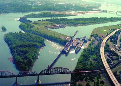
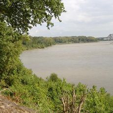
McAlpine Locks and Dam, Navigation lock and hydroelectric dam in Jefferson County, United States

McAlpine Locks and Dam is a navigation lock and hydroelectric dam system spanning the Ohio River that allows boats to pass through a significant drop in elevation. The facility includes two parallel locks and a dam section that converts the river's flow into electrical power.

The system began operation in 1830 as the Louisville and Portland Canal, serving as one of the earliest efforts to improve navigation on the Ohio River. Over time, it was redesigned and renamed to reflect advances in engineering and the contributions of those who developed it.

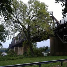
The locks and dam are working places where boat captains and crews pass through regularly, connecting communities along the Ohio River. This passage is part of the rhythm of river life for those who depend on the waterway.

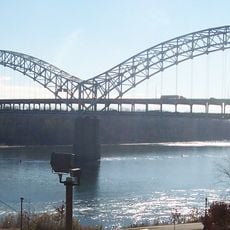
You can watch the system from the shore, especially when boats move through the locks during operation. There are several viewing areas around the facility where you can observe the process from different angles.

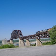
Boats rely on water movement rather than their engines to move through the locks, as the chamber fills and empties to raise and lower vessels. This requires boat captains to carefully control their position using ropes and precise maneuvering rather than engine power.

Location: Jefferson County

Length: 2,630 m

GPS coordinates: 38.27810,-85.79220

Latest update: December 8, 2025 19:51

Photos
Around this place
Falls of the Ohio National Wildlife Conservation Area
United States of America

Falls of the Ohio National Wildlife Conservation Area

2.3 km
Sherman Minton Bridge
United States of America

Sherman Minton Bridge

2.6 km
Kentucky & Indiana Terminal Bridge
United States of America

Kentucky & Indiana Terminal Bridge

974 m
Culbertson Mansion
United States of America

Culbertson Mansion

2 km
Fourteenth Street Bridge
United States of America

Fourteenth Street Bridge

2.6 km
Derby Dinner Playhouse
United States of America

Derby Dinner Playhouse

3.3 km
Town Clock Church
United States of America

Town Clock Church

2.5 km
Squire Earick House
United States of America

Squire Earick House

937 m
United States Marine Hospital of Louisville
United States of America

United States Marine Hospital of Louisville

1.1 km
Scribner House
United States of America

Scribner House

2.7 km
Portland Museum
United States of America

Portland Museum

1.1 km
New Albany National Cemetery
United States of America

New Albany National Cemetery

2.7 km
Carnegie Center for Art & History
United States of America

Carnegie Center for Art & History

2.8 km
New Albany Downtown Historic District
United States of America

New Albany Downtown Historic District

2.7 km
St. Patrick's Roman Catholic Church, Rectory, and School
United States of America

St. Patrick's Roman Catholic Church, Rectory, and School

2.9 km
St. Anthony Roman Catholic Church, Rectory, Convent, and School
United States of America

St. Anthony Roman Catholic Church, Rectory, Convent, and School

2.2 km
Division Street School
United States of America

Division Street School

2 km
St. Peter's German Evangelical Church
United States of America

St. Peter's German Evangelical Church

3.1 km
Montgomery Street School
United States of America

Montgomery Street School

762 m
Cedar Bough Place Historic District
United States of America

Cedar Bough Place Historic District

2.6 km
Church of Our Merciful Saviour
United States of America

Church of Our Merciful Saviour

2.8 km
Theodore Roosevelt Elementary School
United States of America

Theodore Roosevelt Elementary School

2.2 km
Shelby Place Historic District
United States of America

Shelby Place Historic District

2.7 km
DePauw Avenue Historic District
United States of America

DePauw Avenue Historic District

3.1 km
East Spring Street Historic District
United States of America

East Spring Street Historic District

2.4 km
National Tobacco Works Branch Stemmery
United States of America

National Tobacco Works Branch Stemmery

2.4 km
Old Clarksville Site
United States of America

Old Clarksville Site

1.7 km
Culbertson Mansion State Historic Site
United States of America

Culbertson Mansion State Historic Site

2 km
Show the full map
Reviews

Visited this place? Tap the stars to rate it and share your experience / photos with the community! Try now! You can cancel it anytime.

« McAlpine Locks and Dam - Navigation lock and hydroelectric dam in Jefferson County, United States » is provided by Around Us (aroundus.com). Images and texts are derived from Wikimedia project under a Creative Commons license. You are allowed to copy, distribute, and modify copies of this page, under the conditions set by the license, as long as this note is clearly visible.

Discover hidden gems everywhere you go!

From secret cafés to breathtaking viewpoints, skip the crowded tourist spots and find places that match your style. Our app makes it easy with voice search, smart filtering, route optimization, and insider tips from travelers worldwide. Download now for the complete mobile experience.

Around Us App Screenshot

A unique approach to discovering new places

Le Figaro

All the places worth exploring

France Info

A tailor-made excursion in just a few clicks

20 Minutes