·

Enable Location

We need your location to show you interesting places around you

Discover nearby places

Find interesting locations and hidden gems around you

Precise directions

Get accurate directions and distances to places

Your location is never shared with other users. It's only used when you tap the location button.

Sherman Minton Bridge

Log in to your account

Start exploring — it's free

Trusted by 62,638 travelers worldwide

Continue with Google
Continue with Apple
or

We will send you a code to connect

By continuing, you accept our Terms and Conditions and our Privacy Policy

Check your inbox

We've sent a pincode in your inbox. Please enter the code below.

Sherman Minton Bridge

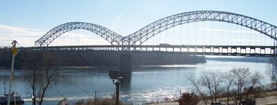
Sherman Minton Bridge, Through arch bridge between Louisville, Kentucky and New Albany, Indiana

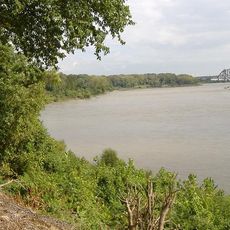
The Sherman Minton Bridge is a through arch bridge that crosses the Ohio River between Louisville, Kentucky, and New Albany, Indiana. It carries Interstate 64 and US Highway 150 with two separate decks stacked vertically to accommodate traffic flowing in opposite directions.

Construction started in 1959 and the bridge was completed in 1962, linking Kentucky and Indiana across the Ohio River. It was named after Sherman Minton, a prominent federal judge and political figure from the region.

The American Institute of Steel Construction recognized this structure as the most beautiful long-span bridge of 1961 for its design.

Roughly 60,000 vehicles cross the bridge daily, making it a major thoroughfare in the region. It remains the only toll-free interstate river crossing in the Louisville area and serves as a practical route for commuters and travelers.

The bridge won recognition from the American Institute of Steel Construction in 1961 for its elegant design and was considered one of the finest steel structures of that era. It uses specialized T1 steel that requires specific maintenance protocols to ensure long-term safety and reliability.

The community of curious travelers

AroundUs brings together thousands of curated places, local tips, and hidden gems, enriched daily by 60,000 contributors worldwide.

Start exploring
Location
Location
Inception
1962
Official opening
1962
GPS coordinates
38.27850,-85.82200
Latest update
December 8, 2025 19:52
Around this place
McAlpine Locks and Dam
United States of America

McAlpine Locks and Dam

2.6 km
Kentucky & Indiana Terminal Bridge
United States of America

Kentucky & Indiana Terminal Bridge

1.8 km
Culbertson Mansion
United States of America

Culbertson Mansion

1.2 km
Town Clock Church
United States of America

Town Clock Church

681 m
Squire Earick House
United States of America

Squire Earick House

1.7 km
United States Marine Hospital of Louisville
United States of America

United States Marine Hospital of Louisville

3.4 km
Scribner House
United States of America

Scribner House

550 m
Chickasaw Park
United States of America

Chickasaw Park

4.1 km
Portland Museum
United States of America

Portland Museum

3.3 km
New Albany National Cemetery
United States of America

New Albany National Cemetery

2.8 km
Carnegie Center for Art & History
United States of America

Carnegie Center for Art & History

916 m
United States of America

Basil Doerhoefer House

3.2 km
New Albany Downtown Historic District
United States of America

New Albany Downtown Historic District

755 m
St. Anthony Roman Catholic Church, Rectory, Convent, and School
United States of America

St. Anthony Roman Catholic Church, Rectory, Convent, and School

3.7 km
Division Street School
United States of America

Division Street School

2.2 km
Woodbine
United States of America

Woodbine

3.1 km
Montgomery Street School
United States of America

Montgomery Street School

3 km
Cedar Bough Place Historic District
United States of America

Cedar Bough Place Historic District

1.9 km
Church of Our Merciful Saviour
United States of America

Church of Our Merciful Saviour

3.9 km
Theodore Roosevelt Elementary School
United States of America

Theodore Roosevelt Elementary School

4.3 km
Shelby Place Historic District
United States of America

Shelby Place Historic District

2.2 km
River Run Water Park
United States of America

River Run Water Park

3.9 km
DePauw Avenue Historic District
United States of America

DePauw Avenue Historic District

2.8 km
East Spring Street Historic District
United States of America

East Spring Street Historic District

1.2 km
William Young House
United States of America

William Young House

755 m
Hedden's Grove Historic District
United States of America

Hedden's Grove Historic District

3.6 km
Old Clarksville Site
United States of America

Old Clarksville Site

4.1 km
Culbertson Mansion State Historic Site
United States of America

Culbertson Mansion State Historic Site

1.2 km
Show the full map
« Sherman Minton Bridge - Through arch bridge between Louisville, Kentucky and New Albany, Indiana » is provided by Around Us (aroundus.com). Images and texts are derived from Wikimedia project under a Creative Commons license. You are allowed to copy, distribute, and modify copies of this page, under the conditions set by the license, as long as this note is clearly visible.

Discover hidden gems everywhere you go!

From secret cafés to breathtaking viewpoints, skip the crowded tourist spots and find places that match your style. Our app makes it easy with voice search, smart filtering, route optimization, and insider tips from travelers worldwide. Download now for the complete mobile experience.

Around Us App Screenshot

A unique approach to discovering new places

Le Figaro

All the places worth exploring

France Info

A tailor-made excursion in just a few clicks

20 Minutes

Around Us
Travel Guide & Maps
Download

Send to your phone

QR Code
1

Open the camera app on your mobile.

2

Point at the QR code with your camera. A notification will appear.

3

Tap the notification to open the link.