Enable Location

We need your location to show you interesting places around you

Discover nearby places

Find interesting locations and hidden gems around you

Precise directions

Get accurate directions and distances to places

Your location is never shared with other users. It's only used when you tap the location button.

Kittanning Citizens Bridge

Log in to your account

Start exploring — it's free

Trusted by 61,336 travelers worldwide

Continue with Google
Continue with Apple
or

We will send you a code to connect

By continuing, you accept our Terms and Conditions and our Privacy Policy

Check your inbox

We've sent a pincode in your inbox. Please enter the code below.

Kittanning Citizens Bridge

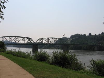
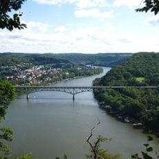
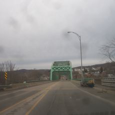
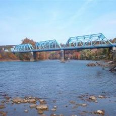
Kittanning Citizens Bridge, Truss bridge in Kittanning, Pennsylvania, United States.

Description

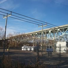
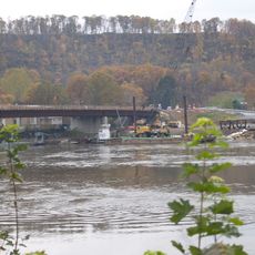
The Kittanning Citizens Bridge is a steel truss bridge spanning 949 feet across the Allegheny River with three main openings. The structure carries three traffic lanes and two sidewalks along Market Street, connecting Kittanning and West Kittanning.

History

McClintic-Marshall Company of Pittsburgh built this bridge in 1932 as the fourth crossing structure at this river location. Previous crossings had included covered bridges and iron structures before this steel design was constructed.

Culture

The bridge gained attention as a filming location for movies in the 2000s, including The Mothman Prophecies and One for the Money. Its distinctive steel structure attracted filmmakers and brought it into popular culture.

Practical

The bridge is accessible by car and on foot, with sidewalks on both sides for safe crossing. When visiting, the structure is best viewed during daylight hours when the steel framework details are most visible.

Did you know?

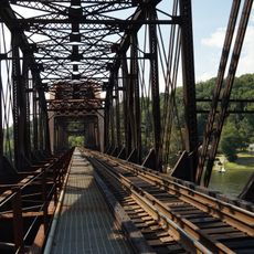
The bridge features heavy lattice portal bracing and intricate v-lacing in its steel framework, reflecting Pennsylvania standard plan design from the early 20th century. This crafted steel design sets it apart from more modern crossings and shows the engineering standards of that period.

Location
Official opening
1932
GPS coordinates
40.81250,-79.52260
Latest update
December 12, 2025 14:23

AroundUs brings together thousands of curated places, local tips, and hidden gems, enriched daily by 60,000 contributors worldwide. Discover all places nearby (Pennsylvania).

Around this place
Rachel Carson Trail
United States of America

Rachel Carson Trail

22.4 km
Burtner House
United States of America

Burtner House

26.7 km
Allegheny River Lock and Dam No. 9
United States of America

Allegheny River Lock and Dam No. 9

16 km
Mahoning Creek Dam
United States of America

Mahoning Creek Dam

23.9 km
Allegheny River Lock and Dam No. 4
United States of America

Allegheny River Lock and Dam No. 4

27.5 km
Harrison Hills Park
United States of America

Harrison Hills Park

23.5 km
Allegheny River Lock and Dam No. 7
United States of America

Allegheny River Lock and Dam No. 7

1.1 km
Drake Log Cabin
United States of America

Drake Log Cabin

26.3 km
St. Gertrude Roman Catholic Church
United States of America

St. Gertrude Roman Catholic Church

23.7 km
Allegheny River Lock and Dam No. 6
United States of America

Allegheny River Lock and Dam No. 6

11.8 km
Allegheny River Lock and Dam No. 5
United States of America

Allegheny River Lock and Dam No. 5

18.6 km
Allegheny River Lock and Dam No. 8
United States of America

Allegheny River Lock and Dam No. 8

9.9 km
Armstrong County Courthouse and Jail
United States of America

Armstrong County Courthouse and Jail

660 m
Saxonburg Historic District
United States of America

Saxonburg Historic District

25.9 km
Donald R. Lobaugh Bridge
United States of America

Donald R. Lobaugh Bridge

21.5 km
Pennsalt Historic District
United States of America

Pennsalt Historic District

27.7 km
Judge J. Frank Graff Bridge
United States of America

Judge J. Frank Graff Bridge

1.8 km
Bradys Bend Iron Company Furnaces
United States of America

Bradys Bend Iron Company Furnaces

22.5 km
Freeport Rail Bridge
United States of America

Freeport Rail Bridge

19.6 km
St. Stephen's Church
United States of America

St. Stephen's Church

22.2 km
Vandergrift Historic District
United States of America

Vandergrift Historic District

23.6 km
Thomas Marshall House
United States of America

Thomas Marshall House

24.8 km
Sergeant Carl F. Curran II Bridge
United States of America

Sergeant Carl F. Curran II Bridge

21.2 km
Leechburg Bridge
United States of America

Leechburg Bridge

22 km
Colwell Cut Viaduct
United States of America

Colwell Cut Viaduct

19.3 km
Bridge between Madison and Mahoning Townships
United States of America

Bridge between Madison and Mahoning Townships

17.4 km
Mill Bridge
United States of America

Mill Bridge

21.6 km
John Roebling House
United States of America

John Roebling House

25.2 km
Show the full map
« Kittanning Citizens Bridge - Truss bridge in Kittanning, Pennsylvania, United States » is provided by Around Us (aroundus.com). Images and texts are derived from Wikimedia project under a Creative Commons license. You are allowed to copy, distribute, and modify copies of this page, under the conditions set by the license, as long as this note is clearly visible.

Discover hidden gems everywhere you go!

From secret cafés to breathtaking viewpoints, skip the crowded tourist spots and find places that match your style. Our app makes it easy with voice search, smart filtering, route optimization, and insider tips from travelers worldwide. Download now for the complete mobile experience.

Around Us App Screenshot

A unique approach to discovering new places

Le Figaro

All the places worth exploring

France Info

A tailor-made excursion in just a few clicks

20 Minutes

Around Us
Travel Guide & Maps
Download

Send to your phone

QR Code
1

Open the camera app on your mobile.

2

Point at the QR code with your camera. A notification will appear.

3

Tap the notification to open the link.