·

Enable Location

We need your location to show you interesting places around you

Discover nearby places

Find interesting locations and hidden gems around you

Precise directions

Get accurate directions and distances to places

Your location is never shared with other users. It's only used when you tap the location button.

Lapping Park

Log in to your account

Start exploring — it's free

Trusted by 62,631 travelers worldwide

Continue with Google
Continue with Apple
or

We will send you a code to connect

By continuing, you accept our Terms and Conditions and our Privacy Policy

Check your inbox

We've sent a pincode in your inbox. Please enter the code below.

Lapping Park

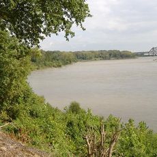
Lapping Park, Public park in Clarksville, United States.

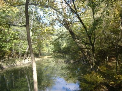
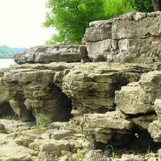
Lapping Park is a 332-acre public park in Clarksville with multiple walking trails, two playgrounds, and sports facilities for various activities. It also features an 18-hole disc golf course, softball fields, horseshoe pits, sand volleyball courts, and a lodge for gatherings.

The property was originally a family camp and farmland before becoming a public park in 1976. Dorothy Lapping Steyn sold the land to the community, preserving the family name in the park's identity.

The lodge here was originally called Flatwoods and still serves as the heart of community gatherings and events throughout the year. Local performances and celebrations happen regularly in the outdoor amphitheater, drawing neighbors from the surrounding area.

The park is open year-round and offers varied activities in one location, making it easy to find something suitable for different interests. Facilities are spread across the property, so visitors can explore at their own pace or focus on specific areas.

A bird survey identified 45 species living in the park, including wood warblers, flycatchers, and blue herons. This variety shows how the natural landscape attracts diverse wildlife throughout the seasons.

The community of curious travelers

AroundUs brings together thousands of curated places, local tips, and hidden gems, enriched daily by 60,000 contributors worldwide.

Start exploring
Location
GPS coordinates
38.33889,-85.77217
Latest update
December 14, 2025 17:03
Around this place
Falls of the Ohio National Wildlife Conservation Area
United States of America

Falls of the Ohio National Wildlife Conservation Area

7 km
McAlpine Locks and Dam
United States of America

McAlpine Locks and Dam

7 km
Colgate Clock
United States of America

Colgate Clock

7.3 km
Kentucky & Indiana Terminal Bridge
United States of America

Kentucky & Indiana Terminal Bridge

6.8 km
Culbertson Mansion
United States of America

Culbertson Mansion

6.8 km
Fourteenth Street Bridge
United States of America

Fourteenth Street Bridge

7.8 km
United States of America

Jeffersonville Quartermaster Depot

6.5 km
Derby Dinner Playhouse
United States of America

Derby Dinner Playhouse

6.7 km
Town Clock Church
United States of America

Town Clock Church

7.4 km
Squire Earick House
United States of America

Squire Earick House

7.5 km
Scribner House
United States of America

Scribner House

7.6 km
Portland Museum
United States of America

Portland Museum

7.8 km
New Albany National Cemetery
United States of America

New Albany National Cemetery

5.2 km
Carnegie Center for Art & History
United States of America

Carnegie Center for Art & History

7.2 km
New Albany Downtown Historic District
United States of America

New Albany Downtown Historic District

7.4 km
Warder Park
United States of America

Warder Park

7.6 km
Henry French House
United States of America

Henry French House

7.9 km
Cedar Bough Place Historic District
United States of America

Cedar Bough Place Historic District

6.2 km
Old Pike Inn
United States of America

Old Pike Inn

7.1 km
Shelby Place Historic District
United States of America

Shelby Place Historic District

5.8 km
DePauw Avenue Historic District
United States of America

DePauw Avenue Historic District

5.3 km
East Spring Street Historic District
United States of America

East Spring Street Historic District

6.8 km
Hedden's Grove Historic District
United States of America

Hedden's Grove Historic District

4.5 km
Old Clarksville Site
United States of America

Old Clarksville Site

5.8 km
Culbertson Mansion State Historic Site
United States of America

Culbertson Mansion State Historic Site

6.8 km
Jeffersonville Township Public Library
United States of America

Jeffersonville Township Public Library

7.6 km
Howard Steamboat Museum
United States of America

Howard Steamboat Museum

7.6 km
Mansion Row Historic District
United States of America

Mansion Row Historic District

6.8 km
Show the full map
« Lapping Park - Public park in Clarksville, United States » is provided by Around Us (aroundus.com). Images and texts are derived from Wikimedia project under a Creative Commons license. You are allowed to copy, distribute, and modify copies of this page, under the conditions set by the license, as long as this note is clearly visible.

Discover hidden gems everywhere you go!

From secret cafés to breathtaking viewpoints, skip the crowded tourist spots and find places that match your style. Our app makes it easy with voice search, smart filtering, route optimization, and insider tips from travelers worldwide. Download now for the complete mobile experience.

Around Us App Screenshot

A unique approach to discovering new places

Le Figaro

All the places worth exploring

France Info

A tailor-made excursion in just a few clicks

20 Minutes

Around Us
Travel Guide & Maps
Download

Send to your phone

QR Code
1

Open the camera app on your mobile.

2

Point at the QR code with your camera. A notification will appear.

3

Tap the notification to open the link.