Enable Location

We need your location to show you interesting places around you

Discover nearby places

Find interesting locations and hidden gems around you

Precise directions

Get accurate directions and distances to places

Your location is never shared with other users. It's only used when you tap the location button.

Lenoir Cotton Mill

Log in to your account

Start exploring — it's free

Trusted by 68,285 travelers worldwide

Continue with Google
Continue with Apple
or

We will send you a code to connect

By continuing, you accept our Terms and Conditions and our Privacy Policy

Check your inbox

We've sent a pincode in your inbox. Please enter the code below.

Discussion Reviews 1 Photos
1.4k Popularity

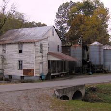
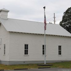
Lenoir Cotton Mill, place in Tennessee listed on National Register of Historic Places

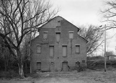
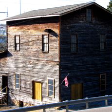
Lenoir Cotton Mill is a brick and stone industrial building in Loudon County, Tennessee, constructed around 1843 to process cotton into yarn and batting using spindles powered by water from Town Creek. The structure features thick walls with internal brick supports, large windows for natural light, and spacious interior spaces designed to house textile machinery and equipment.

William Ballard Lenoir established the mill in the early 1840s as part of his estate after settling in the region in 1810. Following its founding, the Lenoir Manufacturing Company took over operations in 1890 and adapted the building for cloth production and later grain milling, continuing operations until the 1950s.

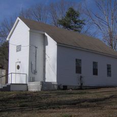
The site is easily accessible via U.S. Route 11 in Lenoir City and is maintained by the city for public viewing. The exterior of the building can be explored freely, allowing visitors to observe the brick and stone construction and the scale of the original structure at their own pace.

During the Civil War, the building was spared from burning by a local Freemason who used a secret sign to warn Union soldiers, suggesting the owners had ties to the organization. The Historic American Buildings Survey systematically documented the structure in the 1930s, creating a permanent record of its architectural details.

The community of curious travelers

AroundUs brings together thousands of curated places, local tips, and hidden gems, enriched daily by 60,000 contributors worldwide.

Start exploring
Location
GPS coordinates
35.79083,-84.26306
Latest update
February 9, 2026 08:18
Around this place
East Tennessee
United States of America

East Tennessee

19.1 km
X-10 Graphite Reactor
United States of America

X-10 Graphite Reactor

16 km
Manhattan Project National Historical Park
United States of America

Manhattan Project National Historical Park

19.9 km
United States of America

Spallation Neutron Source

18.2 km
Fort Loudoun
United States of America

Fort Loudoun

22.4 km
Tellico Blockhouse
United States of America

Tellico Blockhouse

21.9 km
Morganton, Tennessee
United States of America

Morganton, Tennessee

16.7 km
Bussell Island
United States of America

Bussell Island

1.3 km
Icehouse Bottom
United States of America

Icehouse Bottom

22.9 km
George Jones Memorial Baptist Church
United States of America

George Jones Memorial Baptist Church

19.3 km
United States of America

University of Tennessee Arboretum

22.9 km
Clover Hill Mill
United States of America

Clover Hill Mill

21.5 km
Statesview
United States of America

Statesview

21.1 km
Avery Russell House
United States of America

Avery Russell House

13.6 km
Blair's Ferry Storehouse
United States of America

Blair's Ferry Storehouse

8.4 km
United States of America

Fort Loudoun State Park

22.5 km
New Bethel Baptist Church
United States of America

New Bethel Baptist Church

16.3 km
Boyd-Harvey House
United States of America

Boyd-Harvey House

8.9 km
Ebenezer Mill
United States of America

Ebenezer Mill

21.3 km
Craigs Chapel AME Zion Church
United States of America

Craigs Chapel AME Zion Church

17.7 km
William H. Griffitts House
United States of America

William H. Griffitts House

13.4 km
Sir Goony's Family Fun Center
United States of America

Sir Goony's Family Fun Center

15.3 km
Freel Farm Mound Site
United States of America

Freel Farm Mound Site

20.7 km
John M. Rorex House
United States of America

John M. Rorex House

20.5 km
Charles Vanden Bulck Bridge
United States of America

Charles Vanden Bulck Bridge

12 km
John McCroskey House
United States of America

John McCroskey House

21.8 km
Bethel Valley Road Checking Station
United States of America

Bethel Valley Road Checking Station

22.2 km
Oak Ridge Turnpike Checking Station
United States of America

Oak Ridge Turnpike Checking Station

22 km
Show the full map
Reviews
Share your experience

No review yet

Discussions
Start a discussion...

No discussion yet

« Lenoir Cotton Mill - place in Tennessee listed on National Register of Historic Places » is provided by Around Us (aroundus.com). Images and texts are derived from Wikimedia project under a Creative Commons license. You are allowed to copy, distribute, and modify copies of this page, under the conditions set by the license, as long as this note is clearly visible.

Discover hidden gems everywhere you go!

From secret cafés to breathtaking viewpoints, skip the crowded tourist spots and find places that match your style. Our app makes it easy with voice search, smart filtering, route optimization, and insider tips from travelers worldwide. Download now for the complete mobile experience.

Around Us App Screenshot

A unique approach to discovering new places

Le Figaro

All the places worth exploring

France Info

A tailor-made excursion in just a few clicks

20 Minutes

Around Us
Travel Guide & Maps
Download

Send to your phone

QR Code
1

Open the camera app on your mobile.

2

Point at the QR code with your camera. A notification will appear.

3

Tap the notification to open the link.