Enable Location

We need your location to show you interesting places around you

Discover nearby places

Find interesting locations and hidden gems around you

Precise directions

Get accurate directions and distances to places

Your location is never shared with other users. It's only used when you tap the location button.

Neponset Valley Parkway

Log in to your account

Start exploring — it's free

Trusted by 62,937 travelers worldwide

Continue with Google
Continue with Apple
or

We will send you a code to connect

By continuing, you accept our Terms and Conditions and our Privacy Policy

Check your inbox

We've sent a pincode in your inbox. Please enter the code below.

Discussion Reviews 1 Photos
1.3k Popularity

Neponset Valley Parkway, distrikt historik në Shtetet e Bashkuara

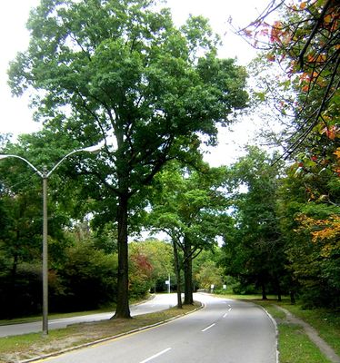
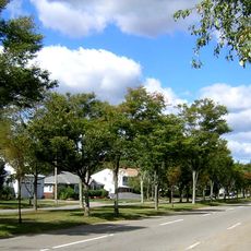
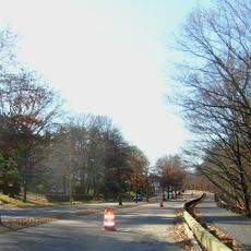
Neponset Valley Parkway is a road in Massachusetts that crosses the Neponset River and connects green spaces with parks. The route runs through residential neighborhoods of Boston and Milton, widening as it approaches the river while providing space for walking and biking paths.

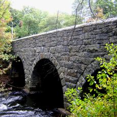
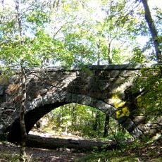
The parkway was built over several decades starting in the late 1800s, with landscape designers Charles Eliot and the Olmsted Brothers helping shape its design. The John Hart Bridge from the 1930s and Paul's Bridge from the 1800s mark important crossings along the route.

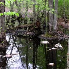
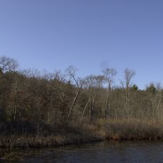
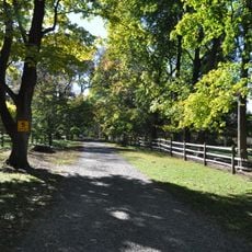
The parkway takes its name from the Neponset River, a waterway central to the local community. Today, visitors see well-maintained green spaces, walking trails, and parks used by people from different neighborhoods and backgrounds.

Visitors can reach the parkway easily using public transit, including commuter rail, buses, and the Mattapan Trolley. Parking is available at key locations like Pope John Paul II Park, making it simple to access walking and biking paths.

Paul's Bridge is a stone arch bridge built in the 1800s that was later widened during parkway construction and remains a defining feature of the route. The John Hart Bridge, built by WPA workers in the 1930s, helped the parkway safely cross railroad tracks near Readville station.

The community of curious travelers

AroundUs brings together thousands of curated places, local tips, and hidden gems, enriched daily by 60,000 contributors worldwide.

Start exploring
Location
GPS coordinates
42.23472,-71.12389
Latest update
February 9, 2026 07:46
Around this place
Fairbanks House
United States of America

Fairbanks House

3.7 km
Blue Hills Reservation
United States of America

Blue Hills Reservation

3.4 km
Great Blue Hill
United States of America

Great Blue Hill

2.7 km
Endicott Estate
United States of America

Endicott Estate

3.3 km
Blue Hill Meteorological Observatory
United States of America

Blue Hill Meteorological Observatory

2.6 km
United States of America

Camp Meigs

966 m
George Wright Golf Course
United States of America

George Wright Golf Course

3.8 km
Eleanor Cabot Bradley Estate
United States of America

Eleanor Cabot Bradley Estate

3.9 km
Stony Brook Reservation
United States of America

Stony Brook Reservation

2.4 km
Eustis Estate
United States of America

Eustis Estate

1.4 km
Fairview Cemetery
United States of America

Fairview Cemetery

1.8 km
Blue Hills Reservation Parkways
United States of America

Blue Hills Reservation Parkways

4.4 km
Great Blue Hill Observation Tower
United States of America

Great Blue Hill Observation Tower

2.5 km
Blue Hills Parkway
United States of America

Blue Hills Parkway

3.4 km
Paul's Bridge
United States of America

Paul's Bridge

119 m
Eliot Memorial Bridge
United States of America

Eliot Memorial Bridge

2.5 km
Parson Barnard House
United States of America

Parson Barnard House

3.3 km
Truman Parkway
United States of America

Truman Parkway

2.8 km
Stony Brook Reservation Parkways
United States of America

Stony Brook Reservation Parkways

3.9 km
Ames Schoolhouse
United States of America

Ames Schoolhouse

4.4 km
First Congregational Church of Hyde Park
United States of America

First Congregational Church of Hyde Park

2.6 km
Comfort Station
United States of America

Comfort Station

1.8 km
Refreshment Pavilion
United States of America

Refreshment Pavilion

3.6 km
Wakefield Estate
United States of America

Wakefield Estate

1.3 km
Brush Hill Historic District
United States of America

Brush Hill Historic District

1.7 km
Metropolitan District Commission Stable
United States of America

Metropolitan District Commission Stable

3.4 km
Milton Centre Historic District
United States of America

Milton Centre Historic District

4.2 km
Scott's Woods Historic District
United States of America

Scott's Woods Historic District

3.8 km
Show the full map
Reviews
Share your experience

No review yet

Discussions
Start a discussion...

No discussion yet

« Neponset Valley Parkway - distrikt historik në Shtetet e Bashkuara » is provided by Around Us (aroundus.com). Images and texts are derived from Wikimedia project under a Creative Commons license. You are allowed to copy, distribute, and modify copies of this page, under the conditions set by the license, as long as this note is clearly visible.

Discover hidden gems everywhere you go!

From secret cafés to breathtaking viewpoints, skip the crowded tourist spots and find places that match your style. Our app makes it easy with voice search, smart filtering, route optimization, and insider tips from travelers worldwide. Download now for the complete mobile experience.

Around Us App Screenshot

A unique approach to discovering new places

Le Figaro

All the places worth exploring

France Info

A tailor-made excursion in just a few clicks

20 Minutes

Around Us
Travel Guide & Maps
Download

Send to your phone

QR Code
1

Open the camera app on your mobile.

2

Point at the QR code with your camera. A notification will appear.

3

Tap the notification to open the link.