Enable Location

We need your location to show you interesting places around you

Discover nearby places

Find interesting locations and hidden gems around you

Precise directions

Get accurate directions and distances to places

Your location is never shared with other users. It's only used when you tap the location button.

Our Lady of Mercy High School

Log in to your account

Start exploring — it's free

Trusted by 62,471 travelers worldwide

Continue with Google
Continue with Apple
or

We will send you a code to connect

By continuing, you accept our Terms and Conditions and our Privacy Policy

Check your inbox

We've sent a pincode in your inbox. Please enter the code below.

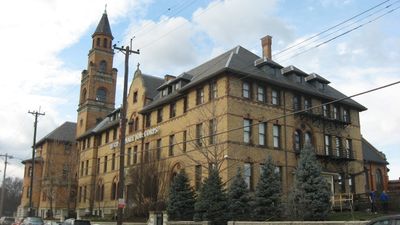
Our Lady of Mercy High School, high school in Ohio

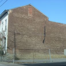
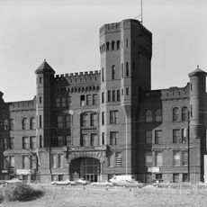
Our Lady of Mercy High School is a school building in Cincinnati, Ohio, constructed from stone and brick with numerous large windows. The structure displays solid, traditional lines and sturdy proportions characteristic of its era.

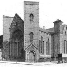
The building was designed many decades ago by Samuel Hannaford & Sons, prominent regional architects responsible for numerous important structures in Cincinnati. It was added to the National Register of Historic Places in 1980, recognizing its significance to local heritage.

The school's name reflects Catholic roots that shaped the community where it stands. For many residents, it remains a recognizable landmark where personal memories and local stories intertwine.

The school building is located on Western Avenue, not far from downtown Cincinnati and easily accessible from local streets. Its size and position make it a straightforward landmark to find and visit in the neighborhood.

The building originally served primarily as a boys' school but has reinvented itself over time, now hosting adult education and job training programs alongside traditional schooling. This evolution shows how this historic structure remains flexible and continues to meet community needs today.

The community of curious travelers

AroundUs brings together thousands of curated places, local tips, and hidden gems, enriched daily by 60,000 contributors worldwide.

Start exploring
Location
Architects
Samuel Hannaford
GPS coordinates
39.11050,-84.53211
Latest update
February 9, 2026 08:18
Around this place
Cincinnati Music Hall
United States of America

Cincinnati Music Hall

1.1 km
Findlay Market
United States of America

Findlay Market

1.2 km
Cathedral Basilica of St. Peter in Chains
United States of America

Cathedral Basilica of St. Peter in Chains

1.4 km
Cincinnati Museum Center at Union Terminal
United States of America

Cincinnati Museum Center at Union Terminal

485 m
Isaac M. Wise Temple
United States of America

Isaac M. Wise Temple

1.4 km
Cincinnati Museum Center at Union Terminal
United States of America

Cincinnati Museum Center at Union Terminal

493 m
Cincinnati City Hall
United States of America

Cincinnati City Hall

1.3 km
American Classical Music Hall of Fame and Museum
United States of America

American Classical Music Hall of Fame and Museum

1.2 km
St. Francis Xavier Church
United States of America

St. Francis Xavier Church

1.4 km
Betts House
United States of America

Betts House

915 m
Laurel Homes Historic District
United States of America

Laurel Homes Historic District

691 m
Dayton Street Historic District
United States of America

Dayton Street Historic District

791 m
Hamilton County Memorial Building
United States of America

Hamilton County Memorial Building

1.2 km
Lloyd Library and Museum
United States of America

Lloyd Library and Museum

1.3 km
Equestrian statue of William Henry Harrison
United States of America

Equestrian statue of William Henry Harrison

1.5 km
The Children's Museum
United States of America

The Children's Museum

445 m
John Hauck House
United States of America

John Hauck House

959 m
Betts-Longworth Historic District
United States of America

Betts-Longworth Historic District

908 m
Saxony Apartment Building
United States of America

Saxony Apartment Building

1.5 km
St. Paul Episcopal Cathedral, Cincinnati
United States of America

St. Paul Episcopal Cathedral, Cincinnati

1.5 km
Ninth Street Historic District
United States of America

Ninth Street Historic District

1.5 km
Apostolic Bethlehem Temple Church
United States of America

Apostolic Bethlehem Temple Church

1.2 km
Goodall Building
United States of America

Goodall Building

1.2 km
Heinrich A. Rattermann House
United States of America

Heinrich A. Rattermann House

1 km
Cincinnati Union Terminal
United States of America

Cincinnati Union Terminal

495 m
Ohio National Guard Armory
United States of America

Ohio National Guard Armory

105 m
Cincinnati History Museum
United States of America

Cincinnati History Museum

459 m
Stargel Stadium
United States of America

Stargel Stadium

726 m
Show the full map
« Our Lady of Mercy High School - high school in Ohio » is provided by Around Us (aroundus.com). Images and texts are derived from Wikimedia project under a Creative Commons license. You are allowed to copy, distribute, and modify copies of this page, under the conditions set by the license, as long as this note is clearly visible.

Discover hidden gems everywhere you go!

From secret cafés to breathtaking viewpoints, skip the crowded tourist spots and find places that match your style. Our app makes it easy with voice search, smart filtering, route optimization, and insider tips from travelers worldwide. Download now for the complete mobile experience.

Around Us App Screenshot

A unique approach to discovering new places

Le Figaro

All the places worth exploring

France Info

A tailor-made excursion in just a few clicks

20 Minutes

Around Us
Travel Guide & Maps
Download

Send to your phone

QR Code
1

Open the camera app on your mobile.

2

Point at the QR code with your camera. A notification will appear.

3

Tap the notification to open the link.