Enable Location

We need your location to show you interesting places around you

Discover nearby places

Find interesting locations and hidden gems around you

Precise directions

Get accurate directions and distances to places

Your location is never shared with other users. It's only used when you tap the location button.

Price Creek Light

Log in to your account

Start exploring — it's free

Trusted by 62,455 travelers worldwide

Continue with Google
Continue with Apple
or

We will send you a code to connect

By continuing, you accept our Terms and Conditions and our Privacy Policy

Check your inbox

We've sent a pincode in your inbox. Please enter the code below.

Price Creek Light

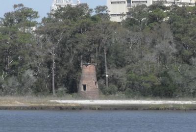
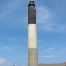
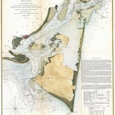
Price Creek Light, Brick lighthouse in Southport, North Carolina, US

Price Creek Light is a small brick lighthouse in Southport, North Carolina, featuring a tapered conical tower. The structure sits on private property and can be seen from the public ferry that crosses the river.

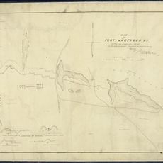
The lighthouse was built in 1849 as one of seven beacons positioned along the Cape Fear River to guide ships. Its lighting system was upgraded in 1855 with more advanced technology.

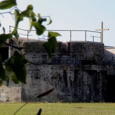
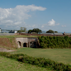
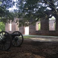
The tower served as a Confederate observation and communication point during the Civil War, connecting two important military forts in the region. Today it stands as a reminder of the area's wartime role along the river.

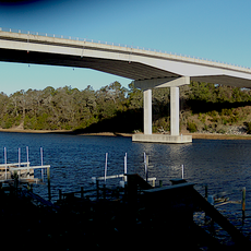
The property is private and cannot be accessed on foot, but the lighthouse is clearly visible from the public ferry crossing. The best views come from the ferry deck during the ride between Southport and Fort Fisher.

The tower originally held eight separate lamps with reflectors, which were replaced by a single advanced optical lens in 1855. This upgrade was part of a broader modernization of lighthouse technology along the American coast.

The community of curious travelers

AroundUs brings together thousands of curated places, local tips, and hidden gems, enriched daily by 60,000 contributors worldwide.

Start exploring
Location
Inception
1849
Height
7.9 m
Made from material
brick
GPS coordinates
33.93580,-77.98970
Latest update
December 12, 2025 07:53
Around this place
Fort Fisher
United States of America

Fort Fisher

7.6 km
Orton Plantation
United States of America

Orton Plantation

14.5 km
Bald Head Light
United States of America

Bald Head Light

7 km
Brunswick Town
United States of America

Brunswick Town

12.2 km
Oak Island Light
United States of America

Oak Island Light

6.4 km
North Carolina Baptist Assembly
United States of America

North Carolina Baptist Assembly

5.6 km
Fort Johnston
United States of America

Fort Johnston

3.2 km
Fort Anderson
United States of America

Fort Anderson

12.3 km
Carolina Beach State Park
United States of America

Carolina Beach State Park

14.7 km
Fort Caswell Historic District
United States of America

Fort Caswell Historic District

6.1 km
Fort Fisher State Recreation Area
United States of America

Fort Fisher State Recreation Area

5.9 km
St. Philip's Church, Brunswick Town
United States of America

St. Philip's Church, Brunswick Town

12.4 km
Cape Fear Light
United States of America

Cape Fear Light

6.4 km
Holden Beach Bridge
United States of America

Holden Beach Bridge

25.7 km
Cameron Art Museum
United States of America

Cameron Art Museum

28.5 km
G. V. Barbee Bridge
United States of America

G. V. Barbee Bridge

7.8 km
New Hope Presbyterian Church
United States of America

New Hope Presbyterian Church

25.3 km
Corncake Inlet, North Carolina
United States of America

Corncake Inlet, North Carolina

4.6 km
Brunswick Town Historic District
United States of America

Brunswick Town Historic District

12.4 km
Swain's Cut Bridge
United States of America

Swain's Cut Bridge

15.7 km
Brunswick County Courthouse
United States of America

Brunswick County Courthouse

3.2 km
Joy Lee Apartment Building and Annex
United States of America

Joy Lee Apartment Building and Annex

14.5 km
Hatch Auditorium
United States of America

Hatch Auditorium

5.5 km
Southport Historic District
United States of America

Southport Historic District

3.4 km
Bald Head Creek Boathouse
United States of America

Bald Head Creek Boathouse

8.3 km
Brunswick Town/Fort Anderson State Historic Site
United States of America

Brunswick Town/Fort Anderson State Historic Site

12.3 km
Old Brunswick County Jail
United States of America

Old Brunswick County Jail

3 km
Fort Fisher State Historic Site
United States of America

Fort Fisher State Historic Site

7.6 km
Show the full map
« Price Creek Light - Brick lighthouse in Southport, North Carolina, US » is provided by Around Us (aroundus.com). Images and texts are derived from Wikimedia project under a Creative Commons license. You are allowed to copy, distribute, and modify copies of this page, under the conditions set by the license, as long as this note is clearly visible.

Discover hidden gems everywhere you go!

From secret cafés to breathtaking viewpoints, skip the crowded tourist spots and find places that match your style. Our app makes it easy with voice search, smart filtering, route optimization, and insider tips from travelers worldwide. Download now for the complete mobile experience.

Around Us App Screenshot

A unique approach to discovering new places

Le Figaro

All the places worth exploring

France Info

A tailor-made excursion in just a few clicks

20 Minutes

Around Us
Travel Guide & Maps
Download

Send to your phone

QR Code
1

Open the camera app on your mobile.

2

Point at the QR code with your camera. A notification will appear.

3

Tap the notification to open the link.