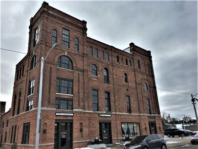
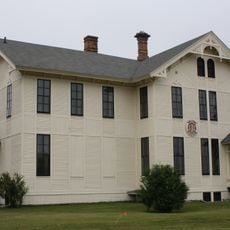
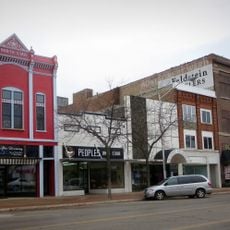
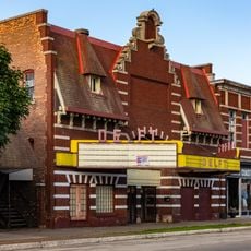
Enable Location

We need your location to show you interesting places around you

Discover nearby places

Find interesting locations and hidden gems around you

Precise directions

Get accurate directions and distances to places

Your location is never shared with other users. It's only used when you tap the location button.

Richter Brewery

Log in to your account

Start exploring — it's free

Trusted by 63,268 travelers worldwide

Continue with Google
Continue with Apple
or

We will send you a code to connect

By continuing, you accept our Terms and Conditions and our Privacy Policy

Check your inbox

We've sent a pincode in your inbox. Please enter the code below.

Discussion Reviews 1 Photos
1.3k Popularity

Richter Brewery

The Richter Brewery is a four-story brick building with corner towers and round-top windows built from 1900 to 1901. Its late Victorian style combined with Romanesque details creates a solid structure that once housed brewing equipment and workers managing beer production for the local area.

The brewery opened in 1901 as the second brewing operation in town, marking an important moment for local industry. After Prohibition closed beer production in 1918, the building reopened as Delta Brewing Company in 1933 but struggled financially and closed by the 1940s.

The name comes from John Richter, the head brewer who brought Milwaukee brewing expertise to Escanaba. Walking around the building today, you can sense how it once connected the town's workers to a proud local industry.

The building sits in downtown Escanaba and is easy to spot thanks to its distinctive brick walls and corner towers. Visit during daytime to see the stonework and architectural details clearly lit by natural light.

During Prohibition, the building shifted to making soda and non-alcoholic drinks instead of beer. When it reopened as Delta Brewing Company in 1933, thousands of townspeople came to celebrate with a parade and free beer.

The community of curious travelers

AroundUs brings together thousands of curated places, local tips, and hidden gems, enriched daily by 60,000 contributors worldwide.

Start exploring
Location
GPS coordinates
45.74639,-87.07083
Latest update
February 9, 2026 07:46
Around this place
Fayette Historic State Park
United States of America

Fayette Historic State Park

32 km
Rock Island State Park
United States of America

Rock Island State Park

41.7 km
Peninsula Point Light
United States of America

Peninsula Point Light

11.9 km
Pilot Island
United States of America

Pilot Island

52.7 km
Spider Cave
United States of America

Spider Cave

29.7 km
Wells State Park
United States of America

Wells State Park

45 km
Sand Point Light
United States of America

Sand Point Light

2.1 km
Pottawatomie Light
United States of America

Pottawatomie Light

40.2 km
Poverty Island Light Station
United States of America

Poverty Island Light Station

40 km
Green Bay National Wildlife Refuge
United States of America

Green Bay National Wildlife Refuge

48.8 km
Minneapolis Shoal Light Station
United States of America

Minneapolis Shoal Light Station

19.2 km
St. Martin Island Light
United States of America

St. Martin Island Light

36.5 km
IXL Historical Museum
United States of America

IXL Historical Museum

41.9 km
Escanaba Central Historic District
United States of America

Escanaba Central Historic District

736 m
School House Beach Park
United States of America

School House Beach Park

40.5 km
Thordarson Estate Historic District
United States of America

Thordarson Estate Historic District

41.9 km
Carnegie Public Library
United States of America

Carnegie Public Library

1.2 km
County Road I-39–Rapid River Bridge
United States of America

County Road I-39–Rapid River Bridge

31.6 km
Water Tower
United States of America

Water Tower

42.5 km
Michigan Theater
United States of America

Michigan Theater

968 m
Jacobsen Museum
United States of America

Jacobsen Museum

39 km
Washington Island Farm Museum
United States of America

Washington Island Farm Museum

41 km
William Bonifas Fine Art Center
United States of America

William Bonifas Fine Art Center

1.1 km
Plum Island Range rear light
United States of America

Plum Island Range rear light

49.6 km
Nahma and Northern Railway no. 5
United States of America

Nahma and Northern Railway no. 5

33.3 km
Plum Island Range front light
United States of America

Plum Island Range front light

50.1 km
Michigan Theatre
United States of America

Michigan Theatre

975 m
Delft Theatre
United States of America

Delft Theatre

829 m
Show the full map
Reviews
Share your experience

No review yet

Discussions
Start a discussion...

No discussion yet

« Richter Brewery » is provided by Around Us (aroundus.com). Images and texts are derived from Wikimedia project under a Creative Commons license. You are allowed to copy, distribute, and modify copies of this page, under the conditions set by the license, as long as this note is clearly visible.

Discover hidden gems everywhere you go!

From secret cafés to breathtaking viewpoints, skip the crowded tourist spots and find places that match your style. Our app makes it easy with voice search, smart filtering, route optimization, and insider tips from travelers worldwide. Download now for the complete mobile experience.

Around Us App Screenshot

A unique approach to discovering new places

Le Figaro

All the places worth exploring

France Info

A tailor-made excursion in just a few clicks

20 Minutes

Around Us
Travel Guide & Maps
Download

Send to your phone

QR Code
1

Open the camera app on your mobile.

2

Point at the QR code with your camera. A notification will appear.

3

Tap the notification to open the link.