·

Enable Location

We need your location to show you interesting places around you

Discover nearby places

Find interesting locations and hidden gems around you

Precise directions

Get accurate directions and distances to places

Your location is never shared with other users. It's only used when you tap the location button.

Escanaba Central Historic District

Log in to your account

Start exploring — it's free

Trusted by 62,725 travelers worldwide

Continue with Google
Continue with Apple
or

We will send you a code to connect

By continuing, you accept our Terms and Conditions and our Privacy Policy

Check your inbox

We've sent a pincode in your inbox. Please enter the code below.

Escanaba Central Historic District, historic district in Michigan, United States

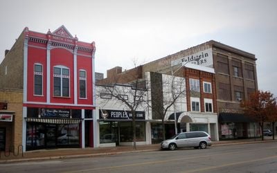
Escanaba Central Historic District is a historic district in downtown Escanaba that stretches primarily along Ludington Street. The area features brick and stone buildings from the late 1800s and early 1900s, with most structures standing two stories tall and originally built to serve as shops, offices, and community gathering spaces.

Escanaba was founded in 1864, with First Avenue originally planned as the main street, but Ludington Street became the business center instead. From the 1880s through the 20th century, buildings were continuously constructed, documenting the city's growth from a small settlement into a prosperous port and industrial town.

The district is easy to walk through, with sidewalks along the streets and many small shops and cafes nearby. The best place to start is Ludington Street in downtown, where most of the historic buildings are located and where you can see architecture from different eras.

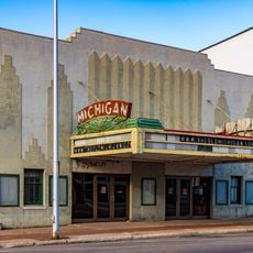
The district contains several buildings with unusual architecture, such as the Michigan Theatre built in 1935 with its distinctive Streamline Moderne facade, which stands out sharply from the more traditional structures. This shows how new design trends from the 1930s reached smaller cities and how architecture evolved over the decades.

The community of curious travelers

AroundUs brings together thousands of curated places, local tips, and hidden gems, enriched daily by 60,000 contributors worldwide.

Start exploring
Location
GPS coordinates
45.74583,-87.06139
Latest update
February 9, 2026 11:07
Around this place
Fayette Historic State Park
United States of America

Fayette Historic State Park

31.3 km
Rock Island State Park
United States of America

Rock Island State Park

41.3 km
Peninsula Point Light
United States of America

Peninsula Point Light

11.4 km
Pilot Island
United States of America

Pilot Island

52.5 km
Spider Cave
United States of America

Spider Cave

28.9 km
Wells State Park
United States of America

Wells State Park

45.3 km
The Clearing Folk School
United States of America

The Clearing Folk School

54.1 km
Pilot Island Light
United States of America

Pilot Island Light

52.5 km
Sand Point Light
United States of America

Sand Point Light

1.3 km
Pottawatomie Light
United States of America

Pottawatomie Light

39.8 km
Poverty Island Light Station
United States of America

Poverty Island Light Station

39.4 km
Green Bay National Wildlife Refuge
United States of America

Green Bay National Wildlife Refuge

48.6 km
Minneapolis Shoal Light Station
United States of America

Minneapolis Shoal Light Station

18.9 km
St. Martin Island Light
United States of America

St. Martin Island Light

35.9 km
IXL Historical Museum
United States of America

IXL Historical Museum

42.6 km
School House Beach Park
United States of America

School House Beach Park

40.2 km
Thordarson Estate Historic District
United States of America

Thordarson Estate Historic District

41.5 km
Carnegie Public Library
United States of America

Carnegie Public Library

450 m
County Road I-39–Rapid River Bridge
United States of America

County Road I-39–Rapid River Bridge

31.5 km
Water Tower
United States of America

Water Tower

42.1 km
Michigan Theater
United States of America

Michigan Theater

232 m
Jacobsen Museum
United States of America

Jacobsen Museum

38.8 km
Washington Island Farm Museum
United States of America

Washington Island Farm Museum

40.7 km
William Bonifas Fine Art Center
United States of America

William Bonifas Fine Art Center

349 m
Plum Island Range rear light
United States of America

Plum Island Range rear light

49.4 km
Nahma and Northern Railway no. 5
United States of America

Nahma and Northern Railway no. 5

32.6 km
Plum Island Range front light
United States of America

Plum Island Range front light

49.9 km
Michigan Theatre
United States of America

Michigan Theatre

239 m
Show the full map
« Escanaba Central Historic District - historic district in Michigan, United States » is provided by Around Us (aroundus.com). Images and texts are derived from Wikimedia project under a Creative Commons license. You are allowed to copy, distribute, and modify copies of this page, under the conditions set by the license, as long as this note is clearly visible.

Discover hidden gems everywhere you go!

From secret cafés to breathtaking viewpoints, skip the crowded tourist spots and find places that match your style. Our app makes it easy with voice search, smart filtering, route optimization, and insider tips from travelers worldwide. Download now for the complete mobile experience.

Around Us App Screenshot

A unique approach to discovering new places

Le Figaro

All the places worth exploring

France Info

A tailor-made excursion in just a few clicks

20 Minutes

Around Us
Travel Guide & Maps
Download

Send to your phone

QR Code
1

Open the camera app on your mobile.

2

Point at the QR code with your camera. A notification will appear.

3

Tap the notification to open the link.