Enable Location

We need your location to show you interesting places around you

Discover nearby places

Find interesting locations and hidden gems around you

Precise directions

Get accurate directions and distances to places

Your location is never shared with other users. It's only used when you tap the location button.

Searights Tollhouse, National Road

Log in to your account

Start exploring — it's free

Trusted by 61,413 travelers worldwide

Continue with Google
Continue with Apple
or

We will send you a code to connect

By continuing, you accept our Terms and Conditions and our Privacy Policy

Check your inbox

We've sent a pincode in your inbox. Please enter the code below.

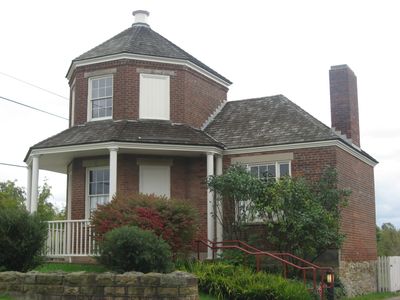
Searights Tollhouse, National Road, National Road tollhouse in Uniontown, Pennsylvania, US

Description

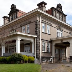
Searights Tollhouse is a toll collection station on the National Road in Uniontown with a distinctive octagonal tower rising two stories, wrapped by a porch, and flanked by single-story wings extending northward and westward. The design positioned toll workers to observe traffic passing in both directions from the upper floor while maintaining living quarters in the same structure.

History

The tollhouse was built in 1835 and collected fees from travelers until Pennsylvania took control of the National Road from the federal government in the 1870s. This transition ended the toll system and converted the road to state management.

Culture

The building shows how toll collection worked in early America, serving as one of only two surviving examples from the original six tollhouses built along Pennsylvania's National Road.

Practical

The building is located on National Pike East and is accessible for tours on weekends with additional appointments available by request. Visitors should confirm current opening times through local resources before making the trip.

Did you know?

The octagonal shape was deliberately chosen to provide sight lines in both directions along the road and ensure no travelers were missed. This geometric design was a practical solution that made the toll collectors' job more efficient.

Location
GPS coordinates
39.94717,-79.79456
Latest update
December 13, 2025 11:43

AroundUs brings together thousands of curated places, local tips, and hidden gems, enriched daily by 60,000 contributors worldwide. Discover all places nearby (Pennsylvania).

Around this place
Bowman's Castle
United States of America

Bowman's Castle

11.3 km
United States of America

Uniontown Speedway

10.6 km
Dunlap's Creek Bridge
United States of America

Dunlap's Creek Bridge

11.5 km
Mount Saint Macrina
United States of America

Mount Saint Macrina

5.8 km
Brownsville Bridge
United States of America

Brownsville Bridge

11.7 km
Penn-Craft Historic District
United States of America

Penn-Craft Historic District

10.2 km
Lane Bane Bridge
United States of America

Lane Bane Bridge

11.6 km
Francis Farm Petroglyphs
United States of America

Francis Farm Petroglyphs

11.5 km
Adam Clarke Nutt Mansion
United States of America

Adam Clarke Nutt Mansion

6.7 km
Peter Colley Tavern and Barn
United States of America

Peter Colley Tavern and Barn

4.8 km
State Theatre Center for the Arts
United States of America

State Theatre Center for the Arts

7.9 km
John S. Douglas House
United States of America

John S. Douglas House

7.7 km
Oak Hill Estate
United States of America

Oak Hill Estate

9.3 km
Uniontown Downtown Historic District
United States of America

Uniontown Downtown Historic District

7.8 km
Wallace-Baily Tavern
United States of America

Wallace-Baily Tavern

7.1 km
Brownsville Northside Historic District
United States of America

Brownsville Northside Historic District

11.1 km
Brier Hill
United States of America

Brier Hill

4.7 km
John P. Conn House
United States of America

John P. Conn House

7.1 km
Hopwood-Miller Tavern
United States of America

Hopwood-Miller Tavern

10.5 km
Laurel Hill Presbyterian Church
United States of America

Laurel Hill Presbyterian Church

8.7 km
Shoaf Historic District
United States of America

Shoaf Historic District

11.8 km
Thomas H. Thompson House
United States of America

Thomas H. Thompson House

11.2 km
Brownsville Commercial Historic District
United States of America

Brownsville Commercial Historic District

11.4 km
Springer Farm
United States of America

Springer Farm

9.3 km
Hugh Laughlin House
United States of America

Hugh Laughlin House

6.9 km
Johnson-Hatfield Tavern
United States of America

Johnson-Hatfield Tavern

3.8 km
Brown-Moore Blacksmith Shop
United States of America

Brown-Moore Blacksmith Shop

9.3 km
Josiah Frost House
United States of America

Josiah Frost House

1.3 km
Show the full map
« Searights Tollhouse, National Road - National Road tollhouse in Uniontown, Pennsylvania, US » is provided by Around Us (aroundus.com). Images and texts are derived from Wikimedia project under a Creative Commons license. You are allowed to copy, distribute, and modify copies of this page, under the conditions set by the license, as long as this note is clearly visible.

Discover hidden gems everywhere you go!

From secret cafés to breathtaking viewpoints, skip the crowded tourist spots and find places that match your style. Our app makes it easy with voice search, smart filtering, route optimization, and insider tips from travelers worldwide. Download now for the complete mobile experience.

Around Us App Screenshot

A unique approach to discovering new places

Le Figaro

All the places worth exploring

France Info

A tailor-made excursion in just a few clicks

20 Minutes

Around Us
Travel Guide & Maps
Download

Send to your phone

QR Code
1

Open the camera app on your mobile.

2

Point at the QR code with your camera. A notification will appear.

3

Tap the notification to open the link.