Enable Location

We need your location to show you interesting places around you

Discover nearby places

Find interesting locations and hidden gems around you

Precise directions

Get accurate directions and distances to places

Your location is never shared with other users. It's only used when you tap the location button.

Shearer's Covered Bridge

Log in to your account

Start exploring — it's free

Trusted by 62,413 travelers worldwide

Continue with Google
Continue with Apple
or

We will send you a code to connect

By continuing, you accept our Terms and Conditions and our Privacy Policy

Check your inbox

We've sent a pincode in your inbox. Please enter the code below.

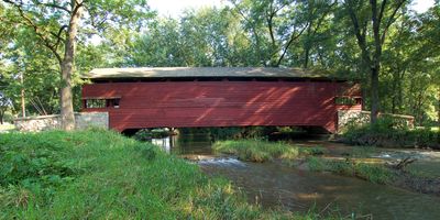
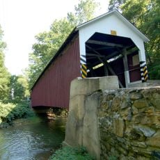
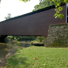
Shearer's Covered Bridge, place in Pennsylvania listed on National Register of Historic Places

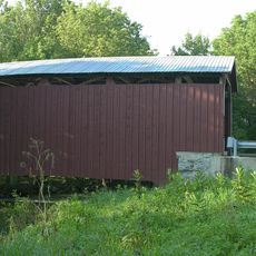
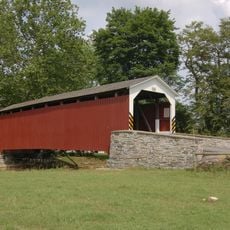
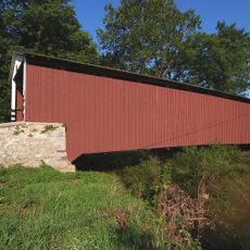
Shearer's Covered Bridge is a wooden structure built in 1847 using a double Burr arch truss design that spans Big Chiques Creek. It measures about 86 feet long (26 meters) and 15 feet wide (4.6 meters), with a clearance of about 11 feet 6 inches (3.5 meters), and now sits in Manheim Memorial Park.

The bridge was built in 1847 by Jacob Clare and underwent major repairs in 1855 before being relocated to Manheim Memorial Park in 1971. It was added to the National Register of Historic Places in 1980, recognizing its importance to regional history.

The bridge was named after the Shearer family who lived nearby and cared for its upkeep over the years. The red paint is a traditional feature of Lancaster County bridges and shapes how locals and visitors see the rural landscape.

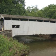
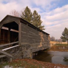
The bridge sits in Manheim Memorial Park and is freely accessible for visitors to view and photograph from all sides. The park features walking paths and information signs explaining its history and construction, making it an easy stop for day trips.

This is the only bridge in Lancaster County painted entirely in red and one of just three structures in the region with horizontal sideboards. This rare combination of features makes it stand out among the area's historic bridges.

The community of curious travelers

AroundUs brings together thousands of curated places, local tips, and hidden gems, enriched daily by 60,000 contributors worldwide.

Start exploring
Location
GPS coordinates
40.17150,-76.38980
Latest update
February 9, 2026 07:43
Around this place
Bomberger's Distillery
United States of America

Bomberger's Distillery

13.1 km
United States of America

Horse-Shoe Trail

12.8 km
Cornwall Iron Furnace
United States of America

Cornwall Iron Furnace

11.1 km
Mount Hope Estate
United States of America

Mount Hope Estate

7 km
The Hess Homestead
United States of America

The Hess Homestead

9 km
Landis Valley Museum
United States of America

Landis Valley Museum

12.8 km
Speedwell Forge
United States of America

Speedwell Forge

7 km
Lititz Moravian Historic District
United States of America

Lititz Moravian Historic District

7.7 km
Siegrist's Mill Covered Bridge
United States of America

Siegrist's Mill Covered Bridge

12.7 km
Alden Villa
United States of America

Alden Villa

11.9 km
Keller's Mill Covered Bridge
United States of America

Keller's Mill Covered Bridge

13.4 km
Stiegel-Coleman House
United States of America

Stiegel-Coleman House

10.8 km
Landis Mill Covered Bridge
United States of America

Landis Mill Covered Bridge

12.1 km
Erb's Covered Bridge
United States of America

Erb's Covered Bridge

12.4 km
Johann Agust Sutter House
United States of America

Johann Agust Sutter House

7.2 km
Kauffman's Distillery Covered Bridge
United States of America

Kauffman's Distillery Covered Bridge

3.1 km
Schenck's Mill Covered Bridge
United States of America

Schenck's Mill Covered Bridge

6.9 km
Manheim Borough Historic District
United States of America

Manheim Borough Historic District

1.1 km
Buck Hill Farm Covered Bridge
United States of America

Buck Hill Farm Covered Bridge

8.8 km
Risser's Mill Covered Bridge
United States of America

Risser's Mill Covered Bridge

10.4 km
United States of America

Nissly Swiss Chocolate Company

13.4 km
William Werner House
United States of America

William Werner House

7.4 km
Colebrook Iron Master's House
United States of America

Colebrook Iron Master's House

12.9 km
George Brown's Sons Cotton and Woolen Mill
United States of America

George Brown's Sons Cotton and Woolen Mill

11.4 km
Brunnerville Road Bridge over Hammer Creek
United States of America

Brunnerville Road Bridge over Hammer Creek

9.8 km
Samuel N. Mumma Tobacco Warehouse
United States of America

Samuel N. Mumma Tobacco Warehouse

8.8 km
Christian Habeck Farm
United States of America

Christian Habeck Farm

12.4 km
Lititz Historical Foundation
United States of America

Lititz Historical Foundation

7.6 km
Show the full map
« Shearer's Covered Bridge - place in Pennsylvania listed on National Register of Historic Places » is provided by Around Us (aroundus.com). Images and texts are derived from Wikimedia project under a Creative Commons license. You are allowed to copy, distribute, and modify copies of this page, under the conditions set by the license, as long as this note is clearly visible.

Discover hidden gems everywhere you go!

From secret cafés to breathtaking viewpoints, skip the crowded tourist spots and find places that match your style. Our app makes it easy with voice search, smart filtering, route optimization, and insider tips from travelers worldwide. Download now for the complete mobile experience.

Around Us App Screenshot

A unique approach to discovering new places

Le Figaro

All the places worth exploring

France Info

A tailor-made excursion in just a few clicks

20 Minutes

Around Us
Travel Guide & Maps
Download

Send to your phone

QR Code
1

Open the camera app on your mobile.

2

Point at the QR code with your camera. A notification will appear.

3

Tap the notification to open the link.