Enable Location

We need your location to show you interesting places around you

Discover nearby places

Find interesting locations and hidden gems around you

Precise directions

Get accurate directions and distances to places

Your location is never shared with other users. It's only used when you tap the location button.

Shepherd Hall

Log in to your account

Start exploring — it's free

Trusted by 62,562 travelers worldwide

Continue with Google
Continue with Apple
or

We will send you a code to connect

By continuing, you accept our Terms and Conditions and our Privacy Policy

Check your inbox

We've sent a pincode in your inbox. Please enter the code below.

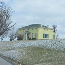
Shepherd Hall, human settlement in United States of America

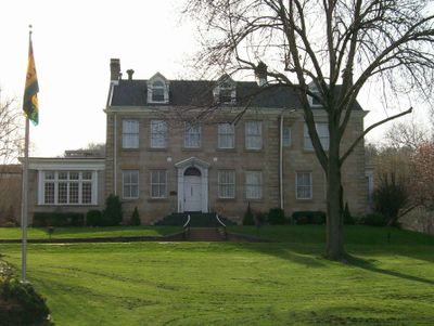
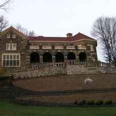
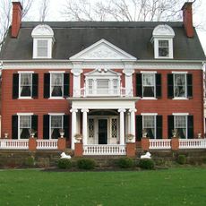
Shepherd Hall is a stone mansion built in 1798 that sits on five acres of land in Wheeling, West Virginia. The two-and-a-half-story structure features thick stone walls, small windows, and a simple classical design that reflects its origins as a family home and working plantation.

Moses Shepherd built the house in 1798 on land his father had acquired, where a small protective fort once stood before being destroyed. The estate later became important for bringing the National Road through Wheeling, significantly boosting local development and connections.

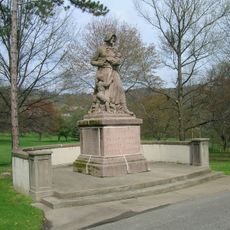
The house became known as Monument Place after a statue honoring Henry Clay was placed on the grounds for his support of the National Road. This name reflects how the Shepherd family's connections shaped local identity and commemoration.

The house sits on a quiet wooded property accessible from Kruger Street and can be viewed from the outside along with the surrounding grounds. Nearby Stone Church Cemetery offers a view of family burial sites connected to the estate's long history.

Lydia Shepherd, the house's longtime resident, lived to be over 100 years old and witnessed both the American Revolution and the Civil War from 1766 to 1867. Her remarkable longevity and social connections meant she hosted numerous political figures and witnessed the nation's transformation across more than a century.

The community of curious travelers

AroundUs brings together thousands of curated places, local tips, and hidden gems, enriched daily by 60,000 contributors worldwide.

Start exploring
Location
GPS coordinates
40.04250,-80.65917
Latest update
February 9, 2026 07:47
Around this place
West Virginia Independence Hall
United States of America

West Virginia Independence Hall

5.9 km
Cathedral of Saint Joseph
United States of America

Cathedral of Saint Joseph

5.8 km
Mount de Chantal Visitation Academy
United States of America

Mount de Chantal Visitation Academy

4.2 km
L. S. Good House
United States of America

L. S. Good House

5.6 km
Elm Grove Stone Arch Bridge
United States of America

Elm Grove Stone Arch Bridge

125 m
Johnson Camden McKinley House
United States of America

Johnson Camden McKinley House

5.8 km
Center Wheeling Market
United States of America

Center Wheeling Market

5.8 km
Chapline Street Row Historic District
United States of America

Chapline Street Row Historic District

5.8 km
Victoria Theater
United States of America

Victoria Theater

6 km
Stratford Springs
United States of America

Stratford Springs

5.8 km
Federal Building and United States Courthouse
United States of America

Federal Building and United States Courthouse

6.1 km
Centre Market Square Historic District
United States of America

Centre Market Square Historic District

5.8 km
Edemar
United States of America

Edemar

3.5 km
Cathedral Parish School
United States of America

Cathedral Parish School

5.8 km
Woodsdale-Edgewood Neighborhood Historic District
United States of America

Woodsdale-Edgewood Neighborhood Historic District

4.3 km
Carter Farm
United States of America

Carter Farm

4.8 km
Highland Park Historic District (Wheeling, West Virginia)
United States of America

Highland Park Historic District (Wheeling, West Virginia)

1.1 km
East Wheeling Historic District
United States of America

East Wheeling Historic District

5.5 km
National Road Corridor Historic District
United States of America

National Road Corridor Historic District

2.9 km
William Miles Tiernan House
United States of America

William Miles Tiernan House

4.7 km
H. C. Ogden House
United States of America

H. C. Ogden House

5.9 km
Elm Hill
United States of America

Elm Hill

6 km
Robert W. Hazlett House
United States of America

Robert W. Hazlett House

6 km
Lang-Hess House
United States of America

Lang-Hess House

5.3 km
Woodridge
United States of America

Woodridge

3.8 km
Fischer-Lasch Farmhouse
United States of America

Fischer-Lasch Farmhouse

5.3 km
Monroe Street East Historic District
United States of America

Monroe Street East Historic District

6 km
Riverside Iron Works Office Building
United States of America

Riverside Iron Works Office Building

6 km
Show the full map
« Shepherd Hall - human settlement in United States of America » is provided by Around Us (aroundus.com). Images and texts are derived from Wikimedia project under a Creative Commons license. You are allowed to copy, distribute, and modify copies of this page, under the conditions set by the license, as long as this note is clearly visible.

Discover hidden gems everywhere you go!

From secret cafés to breathtaking viewpoints, skip the crowded tourist spots and find places that match your style. Our app makes it easy with voice search, smart filtering, route optimization, and insider tips from travelers worldwide. Download now for the complete mobile experience.

Around Us App Screenshot

A unique approach to discovering new places

Le Figaro

All the places worth exploring

France Info

A tailor-made excursion in just a few clicks

20 Minutes

Around Us
Travel Guide & Maps
Download

Send to your phone

QR Code
1

Open the camera app on your mobile.

2

Point at the QR code with your camera. A notification will appear.

3

Tap the notification to open the link.