Chest opened
+${chestReward.xp} XP
Explorer
NOUVEAU ×${chestReward.collectible.quantity}
tapez pour fermer
Chest locked

Open chests in the app

Around Us is built for your phone — chests unlock when you walk, explore and capture nearby places.

Enable Location

We need your location to show you interesting places around you

Discover nearby places

Find interesting locations and hidden gems around you

Precise directions

Get accurate directions and distances to places

Your location is never shared with other users. It's only used when you tap the location button.

Log in to your account

Start exploring — it's free

Trusted by 72,876 travelers worldwide

Continue with Google
Continue with Apple
or

We will send you a code to connect

By continuing, you accept our Terms and Conditions and our Privacy Policy

Check your inbox

We've sent a pincode in your inbox. Please enter the code below.

Stinging Fork Falls State Natural Area
Discussion Reviews Photo
1.9k Popularity

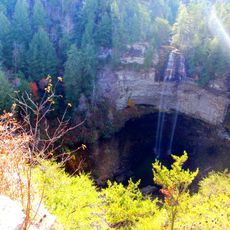
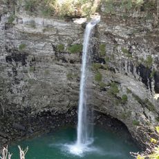
Stinging Fork Falls State Natural Area, Waterfall in Rhea County, Tennessee, United States

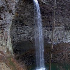
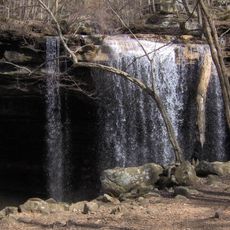
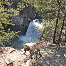
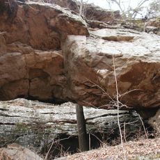
Stinging Fork Falls is a waterfall located within a natural area in Rhea County that cascades over rocky ledges into a forested valley below. The property spans hundreds of acres and offers visitors walking paths that wind through different sections of woodland terrain.

The natural area originated from Pocket Wilderness projects created by a paper company in 1973 as public recreational spaces. This conversion allowed the community to use this forested area for outdoor activities.

This Tennessee Class II Natural-Scientific State Scenic Area provides opportunities for people to connect with nature through hiking and photography.

The main route to the waterfall takes roughly an hour for a round trip and is walkable for most people. It helps to bring water and snacks since the location has limited facilities available.

The location forms one section of a planned hiking network that will connect multiple recreational areas across Tennessee. Visitors can walk through here as part of a longer route rather than treating it as an isolated waterfall destination.

The community of curious travelers

AroundUs brings together thousands of curated places, local tips, and hidden gems, enriched daily by 60,000 contributors worldwide.

Start exploring
Location
GPS coordinates
35.71290,-84.92850
Latest update
December 14, 2025 11:03
Around this place
Fall Creek Falls State Park
United States of America

Fall Creek Falls State Park

38.5 km
Horace Burgess's Treehouse
United States of America

Horace Burgess's Treehouse

30.9 km
Watts Bar Lake
United States of America

Watts Bar Lake

16.8 km
Cumberland Mountain State Park
United States of America

Cumberland Mountain State Park

21.8 km
Ozone Falls State Natural Area
United States of America

Ozone Falls State Natural Area

21.5 km
Cumberland Homesteads
United States of America

Cumberland Homesteads

22.1 km
Ozone Falls
United States of America

Ozone Falls

21.1 km
Scott's Gulf
United States of America

Scott's Gulf

35.5 km
Rhea County Courthouse
United States of America

Rhea County Courthouse

25.4 km
Cane Creek Falls
United States of America

Cane Creek Falls

38.5 km
United States of America

Laurel-Snow State Natural Area

22.4 km
Palace Theater
United States of America

Palace Theater

27.5 km
Rockhouse Falls
United States of America

Rockhouse Falls

38.5 km
Tamke-Allan Observatory
United States of America

Tamke-Allan Observatory

31.1 km
Pikeville Chapel African Methodist Episcopal Zion Church
United States of America

Pikeville Chapel African Methodist Episcopal Zion Church

26.2 km
Lincoln School
United States of America

Lincoln School

26.2 km
Post Oak Springs Christian Church
United States of America

Post Oak Springs Christian Church

32 km
John Bridgman House
United States of America

John Bridgman House

26.1 km
Bledsoe County Courthouse
United States of America

Bledsoe County Courthouse

26.4 km
Cumberland County Courthouse
United States of America

Cumberland County Courthouse

27.6 km
Dr. James A. Ross House
United States of America

Dr. James A. Ross House

26.3 km
Pioneer Hall
United States of America

Pioneer Hall

37.9 km
Broyles-Darwin House
United States of America

Broyles-Darwin House

26.7 km
Plateau Bowling Lanes
United States of America

Plateau Bowling Lanes

27.4 km
Dr. Walter Thomison House
United States of America

Dr. Walter Thomison House

26.6 km
Meigs County Courthouse
United States of America

Meigs County Courthouse

25.4 km
Gooch Creek Arch
United States of America

Gooch Creek Arch

19.7 km
Crossville Model Railroad Club
United States of America

Crossville Model Railroad Club

31 km
Show the full map
Reviews
Share your experience

No review yet

Discussions
Start a discussion...

No discussion yet

« Stinging Fork Falls State Natural Area - Waterfall in Rhea County, Tennessee, United States » is provided by Around Us (aroundus.com). Images and texts are derived from Wikimedia project under a Creative Commons license. You are allowed to copy, distribute, and modify copies of this page, under the conditions set by the license, as long as this note is clearly visible.

Discover hidden gems everywhere you go!

From secret cafés to breathtaking viewpoints, skip the crowded tourist spots and find places that match your style. Our app makes it easy with voice search, smart filtering, route optimization, and insider tips from travelers worldwide. Download now for the complete mobile experience.

Around Us App Screenshot

A unique approach to discovering new places

Le Figaro

All the places worth exploring

France Info

A tailor-made excursion in just a few clicks

20 Minutes

Around Us
Travel Guide & Maps
Download

Send to your phone

QR Code
1

Open the camera app on your mobile.

2

Point at the QR code with your camera. A notification will appear.

3

Tap the notification to open the link.