Enable Location

We need your location to show you interesting places around you

Discover nearby places

Find interesting locations and hidden gems around you

Precise directions

Get accurate directions and distances to places

Your location is never shared with other users. It's only used when you tap the location button.

Mary's River Covered Bridge

Log in to your account

Start exploring — it's free

Trusted by 61,907 travelers worldwide

Continue with Google
Continue with Apple
or

We will send you a code to connect

By continuing, you accept our Terms and Conditions and our Privacy Policy

Check your inbox

We've sent a pincode in your inbox. Please enter the code below.

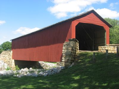
Mary's River Covered Bridge, Covered bridge in Randolph County, US.

Mary's River Covered Bridge is a wooden structure in Randolph County that spans the Little Mary's River using a Burr truss design. The crossing measures approximately 86 feet in length and sits northeast of Chester along Illinois Route 150.

The bridge was built in 1854 as part of a toll road connecting Chester to Bremen and transporting crops to Mississippi River ports. It has been protected by the State of Illinois since 1936.

The bridge represents how rural areas were connected during the 1800s and the role these structures played in local life. Visitors can see today how the wooden crossing linked a community to the wider region.

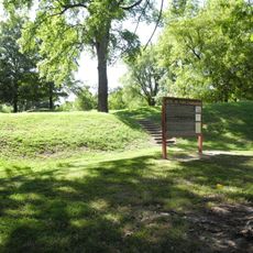
The bridge sits in a designated park area and is easily accessible from Illinois Route 150. Visitors should note that ground conditions around the site vary by season.

This is the only surviving covered bridge in Southern Illinois and retains its original wooden construction from the 1850s. This rarity makes it a significant example of this building style in the region.

The community of curious travelers

AroundUs brings together thousands of curated places, local tips, and hidden gems, enriched daily by 60,000 contributors worldwide.

Start exploring
Location
Inception
1854
GPS coordinates
37.94861,-89.76583
Latest update
December 14, 2025 17:02
Around this place
Fort Kaskaskia State Historic Site
United States of America

Fort Kaskaskia State Historic Site

12.9 km
Chester Bridge
United States of America

Chester Bridge

8 km
Louis Bolduc House
United States of America

Louis Bolduc House

24.6 km
Pierre Menard House
United States of America

Pierre Menard House

12.8 km
Middle Mississippi River National Wildlife Refuge
United States of America

Middle Mississippi River National Wildlife Refuge

13.7 km
United States of America

Kaskaskia Bell State Memorial

13.4 km
Amoureux House
United States of America

Amoureux House

24.3 km
Piney Creek Ravine State Natural Area
United States of America

Piney Creek Ravine State Natural Area

12.6 km
Fults Hill Prairie State Natural Area
United States of America

Fults Hill Prairie State Natural Area

4.4 km
Bois Brule Bottom
United States of America

Bois Brule Bottom

12.3 km
St. James Roman Catholic Church
United States of America

St. James Roman Catholic Church

22.8 km
Le Grand Champ Bottom
United States of America

Le Grand Champ Bottom

20.3 km
St. John the Evangelist Roman Catholic Church
United States of America

St. John the Evangelist Roman Catholic Church

16.6 km
Red Rock Landing Conservation Area, Perry County, Missouri
United States of America

Red Rock Landing Conservation Area, Perry County, Missouri

23.7 km
Tegtmeyer Site
United States of America

Tegtmeyer Site

12.6 km
Zion Lutheran Church
United States of America

Zion Lutheran Church

22.8 km
Randolph County Courthouse
United States of America

Randolph County Courthouse

7.4 km
Lithium Baptist Church
United States of America

Lithium Baptist Church

22.8 km
Cinque Hommes Creek
United States of America

Cinque Hommes Creek

23.3 km
Piney Creek West Site
United States of America

Piney Creek West Site

12.7 km
Piney Creek Site
United States of America

Piney Creek Site

12.8 km
Sparta Historic District (Sparta, Illinois)
United States of America

Sparta Historic District (Sparta, Illinois)

19.8 km
Piney Creek South Site
United States of America

Piney Creek South Site

12.8 km
Frederick Weistar House
United States of America

Frederick Weistar House

7.4 km
Christian F. Weinrich House
United States of America

Christian F. Weinrich House

6.5 km
Bequette-Ribault House
United States of America

Bequette-Ribault House

24.2 km
Lasource-Durand House
United States of America

Lasource-Durand House

24.3 km
Bethlehem Baptist Church
United States of America

Bethlehem Baptist Church

22.8 km
Show the full map
« Mary's River Covered Bridge - Covered bridge in Randolph County, US » is provided by Around Us (aroundus.com). Images and texts are derived from Wikimedia project under a Creative Commons license. You are allowed to copy, distribute, and modify copies of this page, under the conditions set by the license, as long as this note is clearly visible.

Discover hidden gems everywhere you go!

From secret cafés to breathtaking viewpoints, skip the crowded tourist spots and find places that match your style. Our app makes it easy with voice search, smart filtering, route optimization, and insider tips from travelers worldwide. Download now for the complete mobile experience.

Around Us App Screenshot

A unique approach to discovering new places

Le Figaro

All the places worth exploring

France Info

A tailor-made excursion in just a few clicks

20 Minutes

Around Us
Travel Guide & Maps
Download

Send to your phone

QR Code
1

Open the camera app on your mobile.

2

Point at the QR code with your camera. A notification will appear.

3

Tap the notification to open the link.