Piney Creek Ravine State Natural Area

Log in to your account

AroundUs is a community-driven map of interesting places, built by curious explorers like you. It grows with every review, story, and photo you share.
Connect to save your favorite spots, contribute locations, and create personalized routes.
By continuing, you accept our Terms and Conditions and our Privacy Policy

Piney Creek Ravine State Natural Area

Add to collection
Map
Suggest a change
Share

Piney Creek Ravine State Natural Area, Protected natural area in Jackson County, Illinois, US.

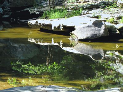
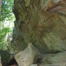
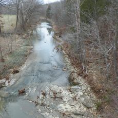
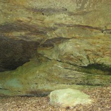
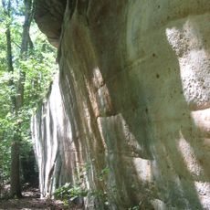
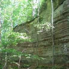
Piney Creek Ravine State Natural Area is a protected natural area in Illinois that contains a creek flowing through a ravine with rock formations and small waterfalls. The terrain supports various native plant species adapted to the steep slopes and moist environment of the canyon.

The site was established as a protected area in 1972 by the Illinois Department of Natural Resources to preserve its geological features and native species. Protection came in response to growing recognition of the need to safeguard rare natural ecosystems in the region.

The cliff faces within the ravine display petroglyphs left by earlier inhabitants during the Late Woodland and Mississippian periods. These carvings remain visible today and tell the story of long human presence in this landscape.

Larger groups should arrange registration with the site office in advance to avoid scheduling conflicts. Sturdy footwear is important due to uneven terrain and moist ground conditions throughout the ravine.

The area contains one of only two natural populations of shortleaf pine trees found in Illinois, making it scientifically valuable for botanical research. This rare pine species is particularly prized within the state for its scarcity and ecological importance.

Location: Jackson County

Location: Randolph County

Inception: 1972

GPS coordinates: 37.89890,-89.63720

Latest update: December 14, 2025 09:47

Photos
Around this place
Kinkaid Lake
United States of America

Kinkaid Lake

21.3 km
Fort Kaskaskia State Historic Site
United States of America

Fort Kaskaskia State Historic Site

25.2 km
Chester Bridge
United States of America

Chester Bridge

17.5 km
Pierre Menard House
United States of America

Pierre Menard House

25 km
Middle Mississippi River National Wildlife Refuge
United States of America

Middle Mississippi River National Wildlife Refuge

24.6 km
Kaskaskia Bell State Memorial
United States of America

Kaskaskia Bell State Memorial

24.5 km
Fults Hill Prairie State Natural Area
United States of America

Fults Hill Prairie State Natural Area

16.8 km
Immanuel Lutheran Church
United States of America

Immanuel Lutheran Church

25.1 km
Bois Brule Bottom
United States of America

Bois Brule Bottom

14.9 km
Cleiman Mound and Village Site
United States of America

Cleiman Mound and Village Site

15.4 km
Mary's River Covered Bridge
United States of America

Mary's River Covered Bridge

12.6 km
St. James Roman Catholic Church
United States of America

St. James Roman Catholic Church

18.8 km
Salem Lutheran Church, Farrar, Missouri
United States of America

Salem Lutheran Church, Farrar, Missouri

22.4 km
St. John the Evangelist Roman Catholic Church
United States of America

St. John the Evangelist Roman Catholic Church

22.9 km
Red Rock Landing Conservation Area, Perry County, Missouri
United States of America

Red Rock Landing Conservation Area, Perry County, Missouri

16.8 km
Tegtmeyer Site
United States of America

Tegtmeyer Site

165 m
Zion Lutheran Church
United States of America

Zion Lutheran Church

18.8 km
Seventy-Six Conservation Area, Perry County, Missouri
United States of America

Seventy-Six Conservation Area, Perry County, Missouri

20 km
Randolph County Courthouse
United States of America

Randolph County Courthouse

16.8 km
Lithium Baptist Church
United States of America

Lithium Baptist Church

18.8 km
Cinque Hommes Creek
United States of America

Cinque Hommes Creek

16.5 km
Piney Creek West Site
United States of America

Piney Creek West Site

223 m
Piney Creek Site
United States of America

Piney Creek Site

243 m
Piney Creek South Site
United States of America

Piney Creek South Site

304 m
Eggers and Company General Store
United States of America

Eggers and Company General Store

22.3 km
Frederick Weistar House
United States of America

Frederick Weistar House

16.8 km
Christian F. Weinrich House
United States of America

Christian F. Weinrich House

16.3 km
Bethlehem Baptist Church
United States of America

Bethlehem Baptist Church

18.8 km
Show the full map
Reviews

Visited this place? Tap the stars to rate it and share your experience / photos with the community! Try now! You can cancel it anytime.

« Piney Creek Ravine State Natural Area - Protected natural area in Jackson County, Illinois, US » is provided by Around Us (aroundus.com). Images and texts are derived from Wikimedia project under a Creative Commons license. You are allowed to copy, distribute, and modify copies of this page, under the conditions set by the license, as long as this note is clearly visible.

Discover hidden gems everywhere you go!

From secret cafés to breathtaking viewpoints, skip the crowded tourist spots and find places that match your style. Our app makes it easy with voice search, smart filtering, route optimization, and insider tips from travelers worldwide. Download now for the complete mobile experience.

Around Us App Screenshot

A unique approach to discovering new places

Le Figaro

All the places worth exploring

France Info

A tailor-made excursion in just a few clicks

20 Minutes