Enable Location

We need your location to show you interesting places around you

Discover nearby places

Find interesting locations and hidden gems around you

Precise directions

Get accurate directions and distances to places

Your location is never shared with other users. It's only used when you tap the location button.

Barn House

Log in to your account

Start exploring — it's free

Trusted by 63,822 travelers worldwide

Continue with Google
Continue with Apple
or

We will send you a code to connect

By continuing, you accept our Terms and Conditions and our Privacy Policy

Check your inbox

We've sent a pincode in your inbox. Please enter the code below.

Discussion Reviews 1 Photos
2.6k Popularity

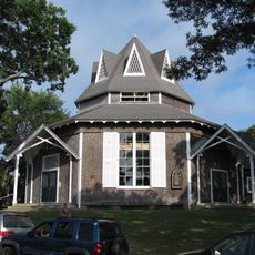
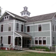
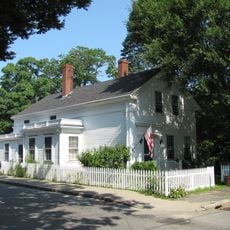
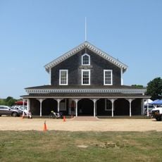
Barn House, Historic district building in Chilmark, US

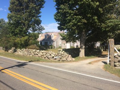
The Barn House is a historic residential building in Chilmark on Martha's Vineyard featuring characteristics typical of the area's 19th-century construction practices. The structure displays traditional materials and building methods used throughout the region.

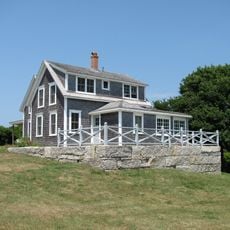
The house was built in the 19th century and documents a period when the island community was shaped mainly by farming and local craft traditions. Its listing on the National Register of Historic Places honors its importance to understanding this rural era.

The house reflects the rural character that shaped Martha's Vineyard for generations, showing how residents used traditional homes as centers of their community life.

The building sits on North Road and can be found easily from there, with straightforward access to the location. Local preservation guidelines mean the exterior remains as it was, which gives the place its distinctive character.

The house takes part of its name from its original purpose, as it shows features suggesting earlier use as a farm building. These details help historians understand the economic structure of early island residents.

The community of curious travelers

AroundUs brings together thousands of curated places, local tips, and hidden gems, enriched daily by 60,000 contributors worldwide.

Start exploring
Location
GPS coordinates
41.34319,-70.73278
Latest update
December 12, 2025 17:46
Around this place
Gay Head Light
United States of America

Gay Head Light

8.6 km
Wesleyan Grove
United States of America

Wesleyan Grove

19 km
Flying Horses Carousel
United States of America

Flying Horses Carousel

19.4 km
Nobska Light
United States of America

Nobska Light

20.3 km
Edgartown Harbor Light
United States of America

Edgartown Harbor Light

19.9 km
Coast Guard Station Woods Hole
United States of America

Coast Guard Station Woods Hole

20.5 km
United States of America

Lambert's Cove Beach

12.8 km
East Chop Light
United States of America

East Chop Light

19.8 km
United States of America

Polly Hill Arboretum

7.5 km
Tarpaulin Cove Light
United States of America

Tarpaulin Cove Light

14.1 km
West Chop Light
United States of America

West Chop Light

18.8 km
Union Chapel
United States of America

Union Chapel

19.1 km
Brewster Islands Military Reservation
United States of America

Brewster Islands Military Reservation

13 km
Edgartown Village Historic District
United States of America

Edgartown Village Historic District

19.1 km
Edwin DeVries Vanderhoop Homestead
United States of America

Edwin DeVries Vanderhoop Homestead

8.6 km
West Chop Club Historic District
United States of America

West Chop Club Historic District

18.7 km
Woods Hole School
United States of America

Woods Hole School

20.9 km
Cuttyhunk Light
United States of America

Cuttyhunk Light

19.8 km
Ritter House
United States of America

Ritter House

16.4 km
Calf Island Military Reservation
United States of America

Calf Island Military Reservation

13.7 km
The Arcade
United States of America

The Arcade

19.2 km
Tashmoo Springs Pumping Station
United States of America

Tashmoo Springs Pumping Station

14.9 km
Dr. Harrison A. Tucker Cottage
United States of America

Dr. Harrison A. Tucker Cottage

19.2 km
William Street Historic District
United States of America

William Street Historic District

16.5 km
Grange Hall
United States of America

Grange Hall

6.4 km
Gay Head-Aquinnah Town Center Historic District
United States of America

Gay Head-Aquinnah Town Center Historic District

6.8 km
Martha's Vineyard Museum
United States of America

Martha's Vineyard Museum

16.2 km
Nomans Land Island National Wildlife Refuge
United States of America

Nomans Land Island National Wildlife Refuge

12 km
Show the full map
Reviews
Share your experience

No review yet

Discussions
Start a discussion...

No discussion yet

« Barn House - Historic district building in Chilmark, US » is provided by Around Us (aroundus.com). Images and texts are derived from Wikimedia project under a Creative Commons license. You are allowed to copy, distribute, and modify copies of this page, under the conditions set by the license, as long as this note is clearly visible.

Discover hidden gems everywhere you go!

From secret cafés to breathtaking viewpoints, skip the crowded tourist spots and find places that match your style. Our app makes it easy with voice search, smart filtering, route optimization, and insider tips from travelers worldwide. Download now for the complete mobile experience.

Around Us App Screenshot

A unique approach to discovering new places

Le Figaro

All the places worth exploring

France Info

A tailor-made excursion in just a few clicks

20 Minutes

Around Us
Travel Guide & Maps
Download

Send to your phone

QR Code
1

Open the camera app on your mobile.

2

Point at the QR code with your camera. A notification will appear.

3

Tap the notification to open the link.