Enable Location

We need your location to show you interesting places around you

Discover nearby places

Find interesting locations and hidden gems around you

Precise directions

Get accurate directions and distances to places

Your location is never shared with other users. It's only used when you tap the location button.

Gay Head Light

Log in to your account

Start exploring — it's free

Trusted by 63,822 travelers worldwide

Continue with Google
Continue with Apple
or

We will send you a code to connect

By continuing, you accept our Terms and Conditions and our Privacy Policy

Check your inbox

We've sent a pincode in your inbox. Please enter the code below.

Discussion Reviews 1 Photos
12.8k Popularity

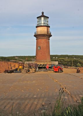
Gay Head Light, Lighthouse in Aquinnah, Massachusetts.

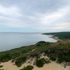
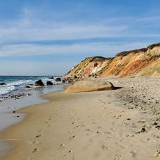
Gay Head Light is a red brick cylindrical tower with a black lantern that stands 15.5 m tall on the western tip of Martha's Vineyard at Devil's Bridge reef. The structure rises prominently above the colored cliff edge, offering views across open water.

A wooden lighthouse was first built in 1799 to protect ships from hazardous reefs in the area. The current brick structure was constructed in 1856 to replace the original tower.

The Wampanoag Native American people have deep ties to these cliffs through their history and presence in the region. The landscape itself holds cultural meaning that extends beyond the lighthouse structure.

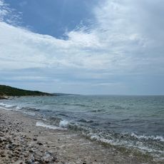
The tower was relocated 40 m from its original position in 2015 to prevent erosion from destroying it. Visitors should be prepared for variable weather on the cliffs and wear appropriate clothing for changing conditions.

The rotating beacon alternates between white and red flashes every 7.5 seconds, guiding vessels through dangerous waters near the reef. This distinctive light pattern has been a reliable marker for captains navigating the area for generations.

The community of curious travelers

AroundUs brings together thousands of curated places, local tips, and hidden gems, enriched daily by 60,000 contributors worldwide.

Start exploring
Location
Inception
1799
Height
15.5 m
Made from material
brick
GPS coordinates
41.34844,-70.83494
Latest update
December 7, 2025 20:43
Around this place
Buzzards Bay Entrance Light
United States of America

Buzzards Bay Entrance Light

17.5 km
Barn House
United States of America

Barn House

8.6 km
United States of America

Lambert's Cove Beach

17.8 km
United States of America

Polly Hill Arboretum

14 km
Tarpaulin Cove Light
United States of America

Tarpaulin Cove Light

14.9 km
Brewster Islands Military Reservation
United States of America

Brewster Islands Military Reservation

4.6 km
Barneys Joy Point Military Reservation
United States of America

Barneys Joy Point Military Reservation

21.9 km
Edwin DeVries Vanderhoop Homestead
United States of America

Edwin DeVries Vanderhoop Homestead

360 m
Cuttyhunk Light
United States of America

Cuttyhunk Light

12.1 km
Calf Island Military Reservation
United States of America

Calf Island Military Reservation

5.2 km
Dumpling Rocks Light
United States of America

Dumpling Rocks Light

22.3 km
Tashmoo Springs Pumping Station
United States of America

Tashmoo Springs Pumping Station

21 km
William Street Historic District
United States of America

William Street Historic District

22.6 km
Gay Head-Aquinnah Town Center Historic District
United States of America

Gay Head-Aquinnah Town Center Historic District

1.9 km
Martha's Vineyard Museum
United States of America

Martha's Vineyard Museum

22.6 km
Nomans Land Island National Wildlife Refuge
United States of America

Nomans Land Island National Wildlife Refuge

10.5 km
Lucy Vincent Beach
United States of America

Lucy Vincent Beach

9.1 km
Silver Beach
United States of America

Silver Beach

17.1 km
Menemsha Hills Reservation Beach
United States of America

Menemsha Hills Reservation Beach

7.3 km
Moshup Beach
United States of America

Moshup Beach

340 m
North Shore Beach
United States of America

North Shore Beach

14.5 km
Menemsha Beach
United States of America

Menemsha Beach

5.9 km
Stonewall Beach
United States of America

Stonewall Beach

7.2 km
West Beach
United States of America

West Beach

12.7 km
Lobsterville Beach
United States of America

Lobsterville Beach

3.7 km
Dumpling Rocks Light
United States of America

Dumpling Rocks Light

22.3 km
Gay Head Town Beach
United States of America

Gay Head Town Beach

1.5 km
Lamberts Cove Beach
United States of America

Lamberts Cove Beach

17.7 km
Show the full map
Reviews
Share your experience

No review yet

Discussions
Start a discussion...

No discussion yet

« Gay Head Light - Lighthouse in Aquinnah, Massachusetts » is provided by Around Us (aroundus.com). Images and texts are derived from Wikimedia project under a Creative Commons license. You are allowed to copy, distribute, and modify copies of this page, under the conditions set by the license, as long as this note is clearly visible.

Discover hidden gems everywhere you go!

From secret cafés to breathtaking viewpoints, skip the crowded tourist spots and find places that match your style. Our app makes it easy with voice search, smart filtering, route optimization, and insider tips from travelers worldwide. Download now for the complete mobile experience.

Around Us App Screenshot

A unique approach to discovering new places

Le Figaro

All the places worth exploring

France Info

A tailor-made excursion in just a few clicks

20 Minutes

Around Us
Travel Guide & Maps
Download

Send to your phone

QR Code
1

Open the camera app on your mobile.

2

Point at the QR code with your camera. A notification will appear.

3

Tap the notification to open the link.