Calf Island Military Reservation

Log in to your account

AroundUs is a community-driven map of interesting places, built by curious explorers like you. It grows with every review, story, and photo you share.
Connect to save your favorite spots, contribute locations, and create personalized routes.
Continue with Google
Continue with Apple
Continue with X
Continue with Facebook
Continue with email
By continuing, you accept our Terms and Conditions and our Privacy Policy
Create an account
Add to collection
Map
Suggest a change
Share

Calf Island Military Reservation, Coastal defense fort in Hull, Massachusetts, United States.

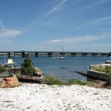
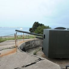
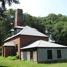
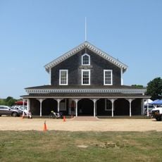
Calf Island Military Reservation is a coastal defense fort located on an island in Hull, Massachusetts, featuring concrete bunkers and observation structures built for harbor surveillance. The installation remains visible with its defensive infrastructure still recognizable across the small island.

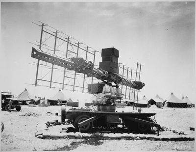
This installation was built in 1941 during World War II to protect Boston Harbor using radar and searchlight technology. It served as part of the American coastal defense network that expanded rapidly during the war years.

Military personnel stationed at the fort developed specific procedures and routines that shaped the daily operations of this coastal defense position.

Access to the island requires water transportation from the mainland, so plan ahead and arrange a boat to visit. Visitors should be prepared for changing water conditions and tidal considerations.

This site was among the first military installations equipped with radar surveillance systems, making it an early adopter of electronic defense technology. The radar capabilities represented a significant shift in how coastal areas were monitored and protected.

Location: Hull

Inception: 1941

GPS coordinates: 41.34105,-70.89613

Latest update: December 14, 2025 18:44

Photos
Around this place
Gay Head Light
United States of America

Gay Head Light

5.2 km
Woods Hole Science Aquarium
United States of America

Woods Hole Science Aquarium

27.7 km
Demarest Lloyd State Park
United States of America

Demarest Lloyd State Park

21.9 km
Coast Guard Station Woods Hole
United States of America

Coast Guard Station Woods Hole

27.7 km
Buzzards Bay Entrance Light
United States of America

Buzzards Bay Entrance Light

13.2 km
Barn House
United States of America

Barn House

13.7 km
United States of America

Lambert's Cove Beach

22.4 km
Slocum's River Reserve
United States of America

Slocum's River Reserve

25.3 km
United States of America

Polly Hill Arboretum

19.1 km
Tarpaulin Cove Light
United States of America

Tarpaulin Cove Light

18.3 km
Brewster Islands Military Reservation
United States of America

Brewster Islands Military Reservation

793 m
Paul Cuffe Farm
United States of America

Paul Cuffe Farm

27.3 km
Normand Edward Fontaine Bridge
United States of America

Normand Edward Fontaine Bridge

24.3 km
Barneys Joy Point Military Reservation
United States of America

Barneys Joy Point Military Reservation

20.2 km
Edwin DeVries Vanderhoop Homestead
United States of America

Edwin DeVries Vanderhoop Homestead

5.1 km
Russells Mills Village Historic District
United States of America

Russells Mills Village Historic District

27.4 km
Cuttyhunk Light
United States of America

Cuttyhunk Light

9.3 km
Ritter House
United States of America

Ritter House

27.5 km
Westport Point Historic District
United States of America

Westport Point Historic District

25.2 km
Dumpling Rocks Light
United States of America

Dumpling Rocks Light

22.1 km
Tashmoo Springs Pumping Station
United States of America

Tashmoo Springs Pumping Station

25.8 km
William Street Historic District
United States of America

William Street Historic District

27.4 km
Grange Hall
United States of America

Grange Hall

19 km
Gay Head-Aquinnah Town Center Historic District
United States of America

Gay Head-Aquinnah Town Center Historic District

6.9 km
Allens Pond Wildlife Sanctuary
United States of America

Allens Pond Wildlife Sanctuary

21.3 km
Martha's Vineyard Museum
United States of America

Martha's Vineyard Museum

27.5 km
Nomans Land Island National Wildlife Refuge
United States of America

Nomans Land Island National Wildlife Refuge

11.7 km
Dumpling Rocks Light
United States of America

Dumpling Rocks Light

22.1 km
Show the full map
Reviews

Visited this place? Tap the stars to rate it and share your experience / photos with the community! Try now! You can cancel it anytime.

« Calf Island Military Reservation - Coastal defense fort in Hull, Massachusetts, United States » is provided by Around Us (aroundus.com). Images and texts are derived from Wikimedia project under a Creative Commons license. You are allowed to copy, distribute, and modify copies of this page, under the conditions set by the license, as long as this note is clearly visible.

Discover hidden gems everywhere you go!

From secret cafés to breathtaking viewpoints, skip the crowded tourist spots and find places that match your style. Our app makes it easy with voice search, smart filtering, route optimization, and insider tips from travelers worldwide. Download now for the complete mobile experience.

Around Us App Screenshot

A unique approach to discovering new places

Le Figaro

All the places worth exploring

France Info

A tailor-made excursion in just a few clicks

20 Minutes