Enable Location

We need your location to show you interesting places around you

Discover nearby places

Find interesting locations and hidden gems around you

Precise directions

Get accurate directions and distances to places

Your location is never shared with other users. It's only used when you tap the location button.

Demarest Lloyd State Park

Log in to your account

Start exploring — it's free

Trusted by 65,537 travelers worldwide

Continue with Google
Continue with Apple
or

We will send you a code to connect

By continuing, you accept our Terms and Conditions and our Privacy Policy

Check your inbox

We've sent a pincode in your inbox. Please enter the code below.

Demarest Lloyd State Park
Discussion Reviews 1 Photos
3k Popularity

Demarest Lloyd State Park, Public beach park in Dartmouth, Massachusetts

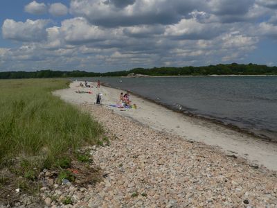
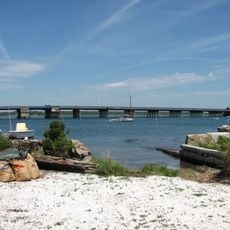
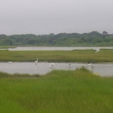
Demarest Lloyd State Park is a coastal park on Buzzards Bay in Dartmouth, Massachusetts, with a long sandy beach and a large salt marsh that covers much of the eastern side of the property. The beach faces the bay directly, and the marsh behind it supports a range of plants and animals adapted to brackish water.

The land was donated to the state of Massachusetts in 1953 by the Russell family, who had owned it for generations. It was named in honor of Demarest Lloyd Sr. and his son, a pilot who died during World War II.

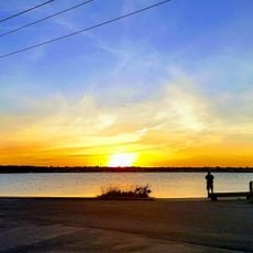
On summer days, families gather along the sandy shore while anglers cast lines into Buzzards Bay. The eastern marsh draws people who prefer watching birds over swimming, so the two areas tend to attract quite different visitors.

Parking is available close to the beach, and from there both the shore and the marsh trails are easy to reach on foot. Arriving early on warm days is a good idea, as the beach area can fill up quickly in summer.

The salt marsh on the eastern side of the park is one of the few spots along this stretch of coast where egrets, herons, and ospreys can be seen nesting at close range. Most visitors head straight to the beach and never walk the short distance to reach this part of the park.

The community of curious travelers

AroundUs brings together thousands of curated places, local tips, and hidden gems, enriched daily by 60,000 contributors worldwide.

Start exploring
Location
Inception
1953
GPS coordinates
41.52630,-70.98329
Latest update
March 3, 2026 13:52
Around this place
Buttonwood Park Zoo
United States of America

Buttonwood Park Zoo

11.8 km
Fort Rodman
United States of America

Fort Rodman

10.1 km
Westport Town Farm
United States of America

Westport Town Farm

10 km
Butler Flats Light
United States of America

Butler Flats Light

11.4 km
Slocum's River Reserve
United States of America

Slocum's River Reserve

3.6 km
Paul Cuffe Farm
United States of America

Paul Cuffe Farm

7.5 km
Apponegansett Meeting House
United States of America

Apponegansett Meeting House

6.5 km
Normand Edward Fontaine Bridge
United States of America

Normand Edward Fontaine Bridge

7.1 km
Buttonwood Park Historic District
United States of America

Buttonwood Park Historic District

12 km
Barneys Joy Point Military Reservation
United States of America

Barneys Joy Point Military Reservation

1.8 km
Russells Mills Village Historic District
United States of America

Russells Mills Village Historic District

5.5 km
William J. Rotch Gothic Cottage
United States of America

William J. Rotch Gothic Cottage

12.4 km
Moreland Terrace Historic District
United States of America

Moreland Terrace Historic District

12 km
Clarks Point Light
United States of America

Clarks Point Light

10.1 km
Hazelwood Park
United States of America

Hazelwood Park

10.6 km
Howland Mill Village Historic District
United States of America

Howland Mill Village Historic District

10.8 km
Westport Point Historic District
United States of America

Westport Point Historic District

7.6 km
Dumpling Rocks Light
United States of America

Dumpling Rocks Light

5.3 km
New Bedford Marine Commerce Terminal
United States of America

New Bedford Marine Commerce Terminal

12.2 km
Russell Garrison
United States of America

Russell Garrison

8.3 km
Cadman-White-Handy House
United States of America

Cadman-White-Handy House

9.3 km
Robert C. Ingraham School
United States of America

Robert C. Ingraham School

11.7 km
Thomas Donaghy School
United States of America

Thomas Donaghy School

12.1 km
Tucker Farm Historic District
United States of America

Tucker Farm Historic District

11.5 km
Thompson Street School
United States of America

Thompson Street School

11.6 km
Allens Pond Wildlife Sanctuary
United States of America

Allens Pond Wildlife Sanctuary

4 km
South End Beach Compass
United States of America

South End Beach Compass

10.1 km
Dumpling Rocks Light
United States of America

Dumpling Rocks Light

5.3 km
Show the full map
Reviews
Share your experience

No review yet

Discussions
Start a discussion...

No discussion yet

« Demarest Lloyd State Park - Public beach park in Dartmouth, Massachusetts » is provided by Around Us (aroundus.com). Images and texts are derived from Wikimedia project under a Creative Commons license. You are allowed to copy, distribute, and modify copies of this page, under the conditions set by the license, as long as this note is clearly visible.

Discover hidden gems everywhere you go!

From secret cafés to breathtaking viewpoints, skip the crowded tourist spots and find places that match your style. Our app makes it easy with voice search, smart filtering, route optimization, and insider tips from travelers worldwide. Download now for the complete mobile experience.

Around Us App Screenshot

A unique approach to discovering new places

Le Figaro

All the places worth exploring

France Info

A tailor-made excursion in just a few clicks

20 Minutes

Around Us
Travel Guide & Maps
Download

Send to your phone

QR Code
1

Open the camera app on your mobile.

2

Point at the QR code with your camera. A notification will appear.

3

Tap the notification to open the link.