Enable Location

We need your location to show you interesting places around you

Discover nearby places

Find interesting locations and hidden gems around you

Precise directions

Get accurate directions and distances to places

Your location is never shared with other users. It's only used when you tap the location button.

Paul Cuffe Farm

Log in to your account

Start exploring — it's free

Trusted by 61,938 travelers worldwide

Continue with Google
Continue with Apple
or

We will send you a code to connect

By continuing, you accept our Terms and Conditions and our Privacy Policy

Check your inbox

We've sent a pincode in your inbox. Please enter the code below.

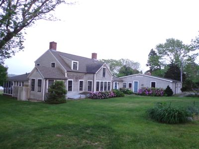
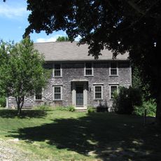
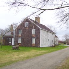
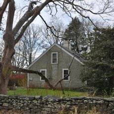
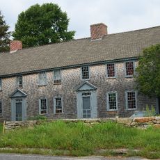
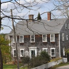
Paul Cuffe Farm, National Historic Landmark farmhouse in Westport, Massachusetts

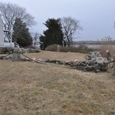
Paul Cuffe Farm is a wooden farmhouse set on a granite foundation with two interior brick chimneys rising from the gabled roof overlooking the East Branch Westport River. The property spans along Drift Road and contains remnants of former wooden-pile wharves and submerged granite blocks from its maritime past.

Built around 1780, the property remained under continuous ownership of the Tripp family from 1748 to 1884, contrary to earlier attributions. The National Historic Landmark designation came in 1974 based on an incorrect association with Paul Cuffe, a prominent African-American merchant.

The farmstead displays typical residential patterns from late 18th-century New England, with handcrafted details and materials that reflect how people lived in rural areas. Visitors can observe how the buildings were designed to serve agricultural life.

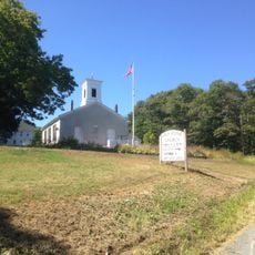
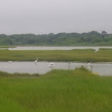
The property sits along Drift Road where visitors can explore the grounds on foot in a rural setting with open spaces and water features. The location requires walking the grounds to fully experience both the building and the remnants scattered across the site.

The farm became known as Paul Cuffe Farm despite being continuously owned by the Tripp family, revealing an error in historical attribution. This naming discrepancy highlights how documentation mistakes led to a misidentified landmark.

The community of curious travelers

AroundUs brings together thousands of curated places, local tips, and hidden gems, enriched daily by 60,000 contributors worldwide.

Start exploring
Location
Inception
1780
GPS coordinates
41.54917,-71.06833
Latest update
December 14, 2025 14:25
Around this place
Buttonwood Park Zoo
United States of America

Buttonwood Park Zoo

13.2 km
Comet
United States of America

Comet

9.9 km
Demarest Lloyd State Park
United States of America

Demarest Lloyd State Park

7.5 km
Westport Town Farm
United States of America

Westport Town Farm

3.6 km
Stone House Inn
United States of America

Stone House Inn

13.5 km
United States of America

Fort Church

12.3 km
Rhode Island Red Monument
United States of America

Rhode Island Red Monument

5 km
Slocum's River Reserve
United States of America

Slocum's River Reserve

4.9 km
Wilbor House
United States of America

Wilbor House

11.5 km
Tiverton Four Corners Historic District
United States of America

Tiverton Four Corners Historic District

10.3 km
Apponegansett Meeting House
United States of America

Apponegansett Meeting House

7.2 km
Little Compton Common Historic District
United States of America

Little Compton Common Historic District

9.7 km
Normand Edward Fontaine Bridge
United States of America

Normand Edward Fontaine Bridge

3.5 km
Buttonwood Park Historic District
United States of America

Buttonwood Park Historic District

13.4 km
Barneys Joy Point Military Reservation
United States of America

Barneys Joy Point Military Reservation

8.3 km
William Whalley Homestead
United States of America

William Whalley Homestead

8.4 km
Russells Mills Village Historic District
United States of America

Russells Mills Village Historic District

5.9 km
Moreland Terrace Historic District
United States of America

Moreland Terrace Historic District

14 km
Howland Mill Village Historic District
United States of America

Howland Mill Village Historic District

13.5 km
Westport Point Historic District
United States of America

Westport Point Historic District

2.9 km
Dumpling Rocks Light
United States of America

Dumpling Rocks Light

12.3 km
Greenvale Farm
United States of America

Greenvale Farm

14.2 km
Russell Garrison
United States of America

Russell Garrison

10.7 km
Cadman-White-Handy House
United States of America

Cadman-White-Handy House

2.6 km
First Baptist Church of Tiverton
United States of America

First Baptist Church of Tiverton

6.4 km
Tucker Farm Historic District
United States of America

Tucker Farm Historic District

11.5 km
Allens Pond Wildlife Sanctuary
United States of America

Allens Pond Wildlife Sanctuary

6 km
Dumpling Rocks Light
United States of America

Dumpling Rocks Light

12.3 km
Show the full map
« Paul Cuffe Farm - National Historic Landmark farmhouse in Westport, Massachusetts » is provided by Around Us (aroundus.com). Images and texts are derived from Wikimedia project under a Creative Commons license. You are allowed to copy, distribute, and modify copies of this page, under the conditions set by the license, as long as this note is clearly visible.

Discover hidden gems everywhere you go!

From secret cafés to breathtaking viewpoints, skip the crowded tourist spots and find places that match your style. Our app makes it easy with voice search, smart filtering, route optimization, and insider tips from travelers worldwide. Download now for the complete mobile experience.

Around Us App Screenshot

A unique approach to discovering new places

Le Figaro

All the places worth exploring

France Info

A tailor-made excursion in just a few clicks

20 Minutes

Around Us
Travel Guide & Maps
Download

Send to your phone

QR Code
1

Open the camera app on your mobile.

2

Point at the QR code with your camera. A notification will appear.

3

Tap the notification to open the link.