Enable Location

We need your location to show you interesting places around you

Discover nearby places

Find interesting locations and hidden gems around you

Precise directions

Get accurate directions and distances to places

Your location is never shared with other users. It's only used when you tap the location button.

Buzzards Bay Entrance Light

Log in to your account

Start exploring — it's free

Trusted by 61,820 travelers worldwide

Continue with Google
Continue with Apple
or

We will send you a code to connect

By continuing, you accept our Terms and Conditions and our Privacy Policy

Check your inbox

We've sent a pincode in your inbox. Please enter the code below.

Buzzards Bay Entrance Light

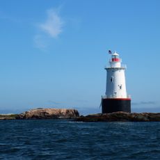
Buzzards Bay Entrance Light, Coastal lighthouse at Buzzards Bay entrance, Massachusetts, US.

Description

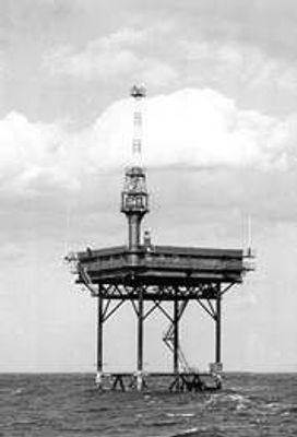
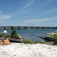
Buzzards Bay Entrance Light is a lighthouse standing on three red steel piles with a central tube in open water, marking the entrance to Buzzards Bay near Cuttyhunk Island. The structure sits in waters that require specialized construction to remain stable.

History

The Coast Guard established this lighthouse in 1961 using a Texas Tower structure to replace lightships that had guided vessels since 1847. This transition from floating to fixed navigation aids represented a major shift in maritime safety methods.

Culture

The first Officer in Charge, Ralph Morris, and his successor Lionel Crossman managed a facility that included living quarters, a kitchen, and recreation spaces.

Practical

The lighthouse emits a white flash every 2.5 seconds at 67 feet (20 meters) above water and has a range of 14 nautical miles (26 kilometers). A dual fog signal system provides additional navigation support when visibility is poor.

Did you know?

Steel support legs extend 268 feet (82 meters) below the water surface to reach bedrock, showcasing the extraordinary engineering required to maintain stability in the 50-foot-deep (15-meter-deep) bay. This deep foundation is often overlooked by visitors focusing only on what they can see above water.

Location
Inception
1961
GPS coordinates
41.39699,-71.03479
Latest update
December 12, 2025 16:40

AroundUs brings together thousands of curated places, local tips, and hidden gems, enriched daily by 60,000 contributors worldwide. Discover all places nearby (Dukes County).

Around this place
Gay Head Light
United States of America

Gay Head Light

17.5 km
Sachuest Point National Wildlife Refuge
United States of America

Sachuest Point National Wildlife Refuge

19.5 km
Demarest Lloyd State Park
United States of America

Demarest Lloyd State Park

15 km
Westport Town Farm
United States of America

Westport Town Farm

20.8 km
Stone House Inn
United States of America

Stone House Inn

14.8 km
United States of America

Fort Church

15.4 km
Rhode Island Red Monument
United States of America

Rhode Island Red Monument

19.1 km
Sakonnet Light
United States of America

Sakonnet Light

15.3 km
Slocum's River Reserve
United States of America

Slocum's River Reserve

17.4 km
Wilbor House
United States of America

Wilbor House

16.7 km
Brewster Islands Military Reservation
United States of America

Brewster Islands Military Reservation

13.9 km
Paul Cuffe Farm
United States of America

Paul Cuffe Farm

17.2 km
Apponegansett Meeting House
United States of America

Apponegansett Meeting House

21.1 km
Little Compton Common Historic District
United States of America

Little Compton Common Historic District

17 km
Normand Edward Fontaine Bridge
United States of America

Normand Edward Fontaine Bridge

13.7 km
Barneys Joy Point Military Reservation
United States of America

Barneys Joy Point Military Reservation

13.3 km
William Whalley Homestead
United States of America

William Whalley Homestead

19.8 km
Edwin DeVries Vanderhoop Homestead
United States of America

Edwin DeVries Vanderhoop Homestead

17.6 km
Russells Mills Village Historic District
United States of America

Russells Mills Village Historic District

19.8 km
Cuttyhunk Light
United States of America

Cuttyhunk Light

7.4 km
Calf Island Military Reservation
United States of America

Calf Island Military Reservation

13.2 km
Westport Point Historic District
United States of America

Westport Point Historic District

14.5 km
Dumpling Rocks Light
United States of America

Dumpling Rocks Light

18.4 km
Cadman-White-Handy House
United States of America

Cadman-White-Handy House

19.8 km
First Baptist Church of Tiverton
United States of America

First Baptist Church of Tiverton

20.4 km
Gay Head-Aquinnah Town Center Historic District
United States of America

Gay Head-Aquinnah Town Center Historic District

19.4 km
Allens Pond Wildlife Sanctuary
United States of America

Allens Pond Wildlife Sanctuary

12.3 km
Dumpling Rocks Light
United States of America

Dumpling Rocks Light

18.4 km
Show the full map
« Buzzards Bay Entrance Light - Coastal lighthouse at Buzzards Bay entrance, Massachusetts, US » is provided by Around Us (aroundus.com). Images and texts are derived from Wikimedia project under a Creative Commons license. You are allowed to copy, distribute, and modify copies of this page, under the conditions set by the license, as long as this note is clearly visible.

Discover hidden gems everywhere you go!

From secret cafés to breathtaking viewpoints, skip the crowded tourist spots and find places that match your style. Our app makes it easy with voice search, smart filtering, route optimization, and insider tips from travelers worldwide. Download now for the complete mobile experience.

Around Us App Screenshot

A unique approach to discovering new places

Le Figaro

All the places worth exploring

France Info

A tailor-made excursion in just a few clicks

20 Minutes

Around Us
Travel Guide & Maps
Download

Send to your phone

QR Code
1

Open the camera app on your mobile.

2

Point at the QR code with your camera. A notification will appear.

3

Tap the notification to open the link.