Enable Location

We need your location to show you interesting places around you

Discover nearby places

Find interesting locations and hidden gems around you

Precise directions

Get accurate directions and distances to places

Your location is never shared with other users. It's only used when you tap the location button.

Cañón de San Cristóbal

Log in to your account

Start exploring — it's free

Trusted by 63,215 travelers worldwide

Continue with Google
Continue with Apple
or

We will send you a code to connect

By continuing, you accept our Terms and Conditions and our Privacy Policy

Check your inbox

We've sent a pincode in your inbox. Please enter the code below.

Cañón de San Cristóbal
Discussion Reviews 2 Photos 1 Collections
100+ Popularity

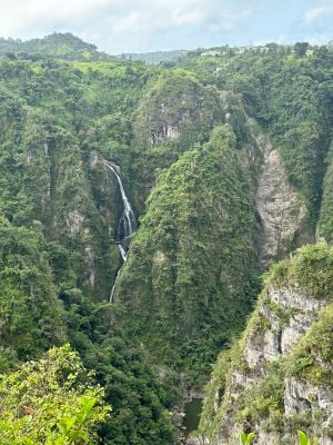
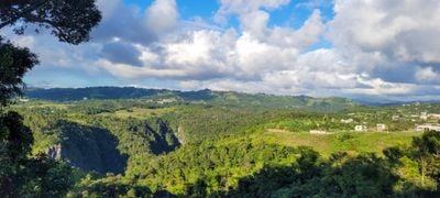
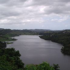
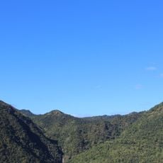
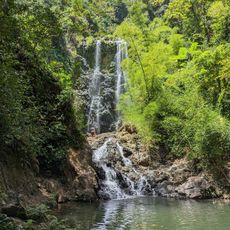
Cañón de San Cristóbal, Protected natural valley in central Puerto Rico.

This valley system runs nine kilometers through Barranquitas and Aibonito municipalities, with walls descending 750 feet (230 meters) at their deepest points along the route.

Municipal authorities operated a landfill within the gorge between 1954 and 1974, after which the Department of Natural Resources declared it a Protected Natural Area in 1978.

Local residents have honored the site by naming it after Saint Christopher, whom Puerto Ricans have regarded as patron of travelers since the nineteenth century.

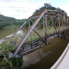
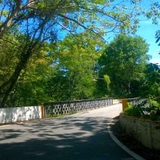
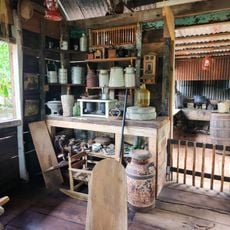
Three entry points provide access Monday through Saturday: Finca Don Félix and Cañón San Cristóbal Recreation Area in Barranquitas, plus Finca Los Llanos in Aibonito municipality.

Flowing waters of the Usabón River spent millions of years cutting through layers of sedimentary and igneous rock formations that date back ninety to one hundred million years.

The community of curious travelers

AroundUs brings together thousands of curated places, local tips, and hidden gems, enriched daily by 60,000 contributors worldwide.

Start exploring
Location
Address
Carr.156, Km. 17.7 interior, Bo. Honduras, Barranquitas, PR, Barranquitas 00794, Puerto Rico
Opening Hours
Monday-Saturday 07:00-16:00
Phone
GPS coordinates
18.16913,-66.29156
Latest update
December 1, 2025 16:08
Places to discover in Puerto Rico

Puerto Rico offers more than the beaches and colonial fortresses of San Juan. The island contains dozens of natural swimming pools, remote coastal sections and protected forest reserves. The northern coast holds limestone caves with pre-Columbian petroglyphs, while the southwest region includes...

Around this place
El Yunque National Forest
United States of America

El Yunque National Forest

56.2 km
Toro Negro State Forest
United States of America

Toro Negro State Forest

25.1 km
Monumento al Jíbaro Puertorriqueño
United States of America

Monumento al Jíbaro Puertorriqueño

13.4 km
Central Aguirre Historic District
United States of America

Central Aguirre Historic District

24.8 km
La Plata Lake
United States of America

La Plata Lake

18.4 km
Bayamón Soccer Complex
United States of America

Bayamón Soccer Complex

25.6 km
San Ramón Nonato Church
United States of America

San Ramón Nonato Church

26.1 km
Arenas Bridge
United States of America

Arenas Bridge

16.7 km
Mavilla Bridge
United States of America

Mavilla Bridge

20.4 km
San Blas de Illescas Church (Coamo)
United States of America

San Blas de Illescas Church (Coamo)

12 km
United States of America

La Robleda Natural Protected Area

17.8 km
Old Plata Bridge
United States of America

Old Plata Bridge

17.4 km
Museo de Vida Silvestre
United States of America

Museo de Vida Silvestre

25.3 km
United States of America

Cerro El Bolo

21.6 km
Planadas-Yeyesa Nature Reserve
United States of America

Planadas-Yeyesa Nature Reserve

12.2 km
La Liendre Bridge
United States of America

La Liendre Bridge

17.3 km
Puente de las Calabazas
United States of America

Puente de las Calabazas

9.3 km
Pico Pomar Residence
United States of America

Pico Pomar Residence

11.9 km
Casa Natal de Luis Muñoz Rivera
United States of America

Casa Natal de Luis Muñoz Rivera

2.8 km
Río Hondo Bridge
United States of America

Río Hondo Bridge

6.8 km
General Méndez Vigo Bridge
United States of America

General Méndez Vigo Bridge

14.6 km
Hacienda Los Maldonado
Puerto Rico

Hacienda Los Maldonado

13.8 km
Cascada Charco Prieto
Puerto Rico

Cascada Charco Prieto

17 km
Jesús Izcoa Moure Bridge
United States of America

Jesús Izcoa Moure Bridge

19.4 km
La Casa del Cuento y de la Historia Cayeyana Ramón "Moncho" Gómez
United States of America

La Casa del Cuento y de la Historia Cayeyana Ramón "Moncho" Gómez

14.8 km
Carretera Central historic district
United States of America

Carretera Central historic district

5 km
Lago Toa Vaca
United States of America

Lago Toa Vaca

20.7 km
Lago Guayabal
United States of America

Lago Guayabal

23.8 km
Show the full map
Reviews
Share your experience

No review yet

Discussions
Start a discussion...

No discussion yet

« Cañón de San Cristóbal - Protected natural valley in central Puerto Rico » is provided by Around Us (aroundus.com). Images and texts are derived from Wikimedia project under a Creative Commons license. You are allowed to copy, distribute, and modify copies of this page, under the conditions set by the license, as long as this note is clearly visible.

Discover hidden gems everywhere you go!

From secret cafés to breathtaking viewpoints, skip the crowded tourist spots and find places that match your style. Our app makes it easy with voice search, smart filtering, route optimization, and insider tips from travelers worldwide. Download now for the complete mobile experience.

Around Us App Screenshot

A unique approach to discovering new places

Le Figaro

All the places worth exploring

France Info

A tailor-made excursion in just a few clicks

20 Minutes

Around Us
Travel Guide & Maps
Download

Send to your phone

QR Code
1

Open the camera app on your mobile.

2

Point at the QR code with your camera. A notification will appear.

3

Tap the notification to open the link.