See the monuments around you in AROpen chests in the app
Around Us is built for your phone — point your camera at the streets and discover the monuments and places around you in augmented reality.Around Us is built for your phone — chests unlock when you walk, explore and capture nearby places.
Puerto Rico offers more than the beaches and colonial fortresses of San Juan. The island contains dozens of natural swimming pools, remote coastal sections and protected forest reserves. The northern coast holds limestone caves with pre-Columbian petroglyphs, while the southwest region includes bioluminescent bays and extensive salt flats. The interior features waterfalls cascading over volcanic rock and hiking trails through mountain canyons with native vegetation.
Historic sites include 19th-century lighthouses on rocky promontories, Spanish fortifications guarding harbor entrances and archaeological sites like the indigenous ceremonial center of Tibes near Ponce. Coastal areas offer natural swimming holes separated from the sea at low tide, including Las Paylas in Luquillo and Pozo de Jacinto in Isabela. The dry coastal forests of Guánica and the wet rainforest of El Yunque show the range of the island's ecosystems.
Visitors reach these locations via local roads that are often unpaved and poorly marked. Many natural pools and waterfalls require short hikes over uneven terrain. The best conditions occur during the dry season from December through April, when river flows run lower. Some locations like Reserva Natural Las Cabezas de San Juan require advance booking for guided tours, while others remain freely accessible year-round.
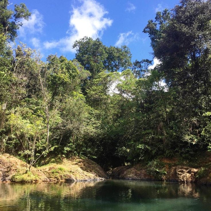
Charco Azul is a natural freshwater pool within Carite Forest Reserve that offers visitors a chance to swim and explore the island's interior. Reaching the pool requires a hike along a forest trail that winds through the reserve, passing rocks and native vegetation. The water is clear and cold, fed by a nearby stream. The reserve offers several hiking trails and picnic areas for day trips. Weekends bring more people, while weekdays tend to be quieter.
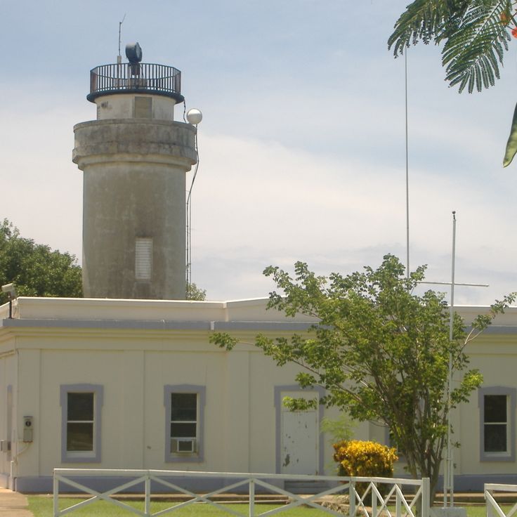
The Punta Borinquen Lighthouse is part of Puerto Rico's collection of sites beyond beaches and colonial fortresses. This white stone structure was built in 1889 on a coastal cliff and continues to serve as a navigation point for vessels crossing the Atlantic. From its elevated position, the lighthouse offers broad views across the ocean and the rugged northwest coast. The site sits on a rocky promontory that has guided mariners for over a century. Visitors can explore the exterior grounds and take in the seaward views, while the historic architecture speaks to Puerto Rico's long maritime heritage.
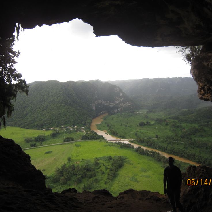
In the collection of places to discover in Puerto Rico, Cueva Ventana shows one of the limestone caves that shape the northern coast. This cave has a large natural opening that works like a window onto the Arecibo valley. A paved path leads through tropical forest to the cave, where the rock face opens to reveal agricultural plains below. The cave sits about 700 feet (213 meters) above sea level and displays the porous limestone structure that marks this region.
Las Paylas in Luquillo is a natural rock formation in the rainforest where flowing water has smoothed stone into slides that channel streams into a series of connected pools. Over centuries, the current has shaped the surfaces into natural channels where visitors can glide down into the lower basins. The site sits along a stream in the forested area east of Luquillo and requires a hike over a steep and often muddy trail. The pools differ in depth and size, with some deep enough for swimming while others serve as starting points for sliding. Water flow changes depending on recent rainfall, and the rock surfaces can be slippery.
Pozo de Jacinto is a coastal rock formation along Puerto Rico's northern coast where waves force water through small openings to create fountains of spray. This natural pool fits within the collection of places that show the island's diverse geology and the power of ocean forces. Local residents share stories about a shepherd who disappeared at this location, adding layers of local legend to the site. The formation lets ocean water enter through gaps when waves reach sufficient force.
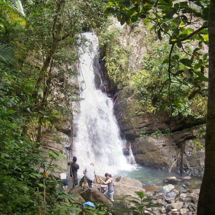
Charco Prieto Waterfall is one of the natural swimming pools found across Puerto Rico. Water cascades over a rocky ledge into a rounded pool surrounded by thick tropical forest. A narrow trail cuts through the forest and takes about 20 minutes to walk. The pool is deep enough for swimming and draws mostly local residents who come to cool off on weekends. Water flows steadily throughout the year but can rise significantly after heavy rain. Sturdy shoes are essential since rocks around the pool become slippery.
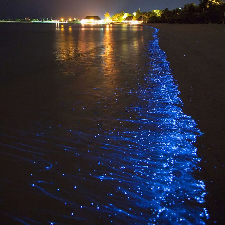
This bay in Lajas displays a natural wonder found throughout Puerto Rico's protected waters. The Bahia Bioluminiscente contains millions of dinoflagellates, single-celled organisms that produce blue light when disturbed in the water. The phenomenon becomes visible after dark, when paddles, boats, or swimming motion agitate the plankton and trigger the glow. The bay sits within a mangrove system that maintains the conditions these microorganisms need to thrive. Kayak tours after nightfall let visitors observe the bioluminescence up close.
The salt flats of Cabo Rojo are seawater evaporation ponds that produce salt on Puerto Rico's southwestern coast. The water in these rectangular basins shifts from pink to orange depending on salt levels and sun exposure, colored by microorganisms and minerals. These working salt flats have operated for centuries and spread between the ocean and mangrove forests. Visitors can view the ponds from access roads, though entry to production areas is restricted. The salt flats of Cabo Rojo represent the kind of natural and historical sites that offer visitors more than the beaches and colonial fortresses of San Juan.
Gilligan's Island is part of Puerto Rico's varied natural attractions beyond San Juan. This small cay off the coast of Guánica features protected lagoons with shallow waters for swimming and snorkeling. Mangrove channels surround the island and accessible coral reefs are suitable for kayaking. Visitors reach the island by boat or kayak from the mainland. The calm waters and natural surroundings draw day-trippers year-round.
The Cambalache Forest, a protected reserve south of Arecibo, shows the natural variety of Puerto Rico that goes beyond beaches and colonial sites. This forest features marked trails through subtropical vegetation and displays distinctive limestone formations with hills and sinkholes found on the island's northern coast. Native tree species including various palms and hardwoods fill the canopy. Different bird species make their homes in the dense forest layers. The trails wind through changing vegetation zones and reveal the forest's ecological diversity.
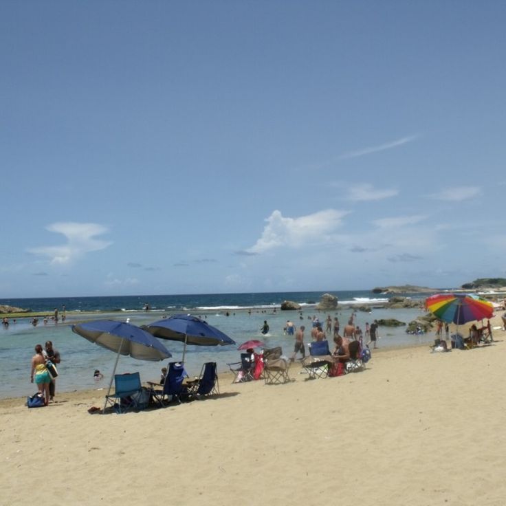
Mar Chiquita is one of the many swimming spots that Puerto Rico offers beyond the famous beaches of San Juan. This natural pool sits on the north coast and is shaped by limestone walls that form a protected cove. Seawater flows through openings in the rock, creating a swimming area with white sand. The water is suitable for swimming when conditions are calm, but waves and currents change with the tides and ocean swells. Local visitors come here to swim and picnic, especially on weekends.
El Cañuelo Fortress was built in 1610 as a Spanish defensive structure to monitor access to San Juan Bay. The stone fortification features guard posts and thick masonry walls facing the Atlantic Ocean. When exploring Puerto Rico, you can visit this fortress while discovering the Spanish fortifications that guarded the harbor entrances across the island.
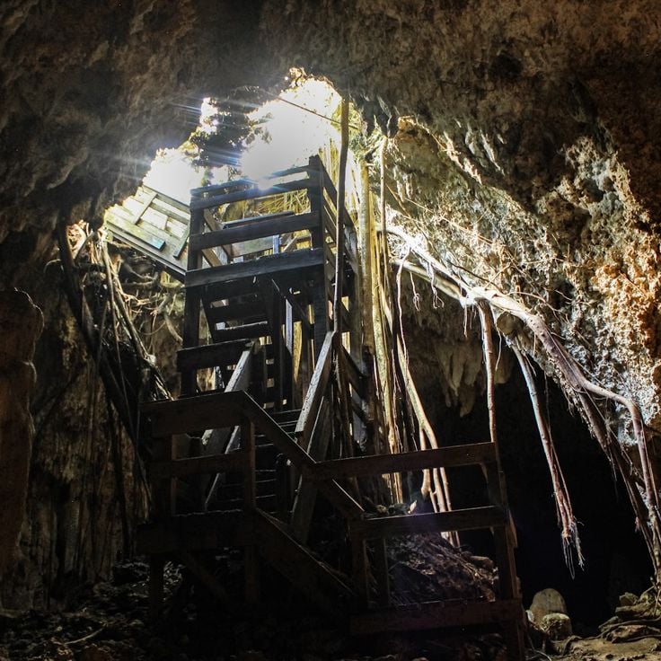
Cuevas del Indio represents the hidden treasures Puerto Rico offers beyond San Juan's beaches and colonial fortresses. These coastal caves north of Arecibo preserve Taíno rock carvings and limestone formations shaped over centuries by the sea. Visitors follow a path along the cliffs to several interconnected grottos where petroglyphs remain visible on the walls. Waves crash against the rocks, having carved arches and overhangs over time. Access requires sturdy footwear and caution on wet surfaces near the openings. Guided tours explain the significance of the symbols and the geology of the site.
Caja de Muertos Island is one of the places that shows Puerto Rico beyond the beaches and fortresses of San Juan. This uninhabited nature reserve sits off the southern coast and features sandy beaches, dry coastal forest with hiking trails, and a lighthouse built in 1887 on the island's highest point. Visitors can snorkel in designated areas and explore a small museum that documents the island's history. Access is by authorized tour boats departing from Ponce.
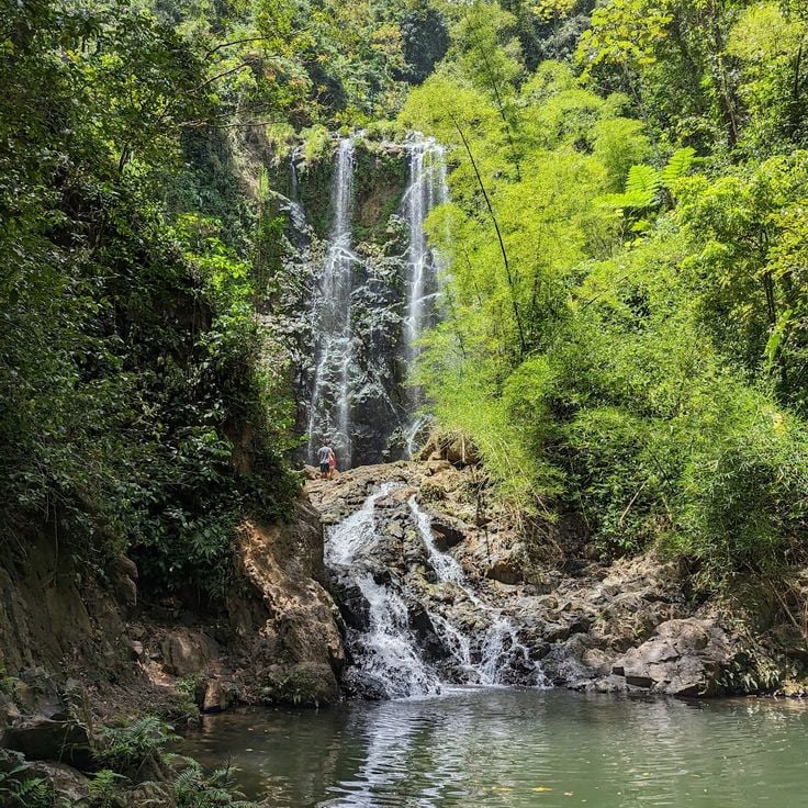
Salto Curet sits within the Maricao forest reserve and represents one of the natural waterfalls and swimming pools found throughout Puerto Rico. The waterfall drops over moss-covered rocks into several shallow terraced pools suitable for swimming. A forest trail leads through dense woodland with ferns and bamboo growing along the banks to reach the falls. The path can become slippery after rainfall. The surrounding rainforest shows the wet landscape of western Puerto Rico, contrasting with the drier coastal forests found elsewhere on the island.
This nature reserve is one of the places to discover across Puerto Rico. It protects a coastal landscape with seven different ecosystems, including mangrove forests, coral reefs and lagoons. The lighthouse El Faro dates from 1882 and offers views of the surrounding waters and offshore cays. Laguna Grande is home to microorganisms that emit light when disturbed at night. Trails wind through the mangrove forests and along the coast, where visitors can observe various bird species and marine life.
La Pocita de las Golondrinas is one of the natural swimming pools that defines this guide to Puerto Rico. This tidal pool sits along the northern coast of Manatí where seawater settles between rock formations to create sheltered swimming areas at low tide. The pool sits directly on the Atlantic shoreline and refills with each tide, maintaining constant water circulation. The rock structure offers natural protection from stronger waves and currents. Local swimmers and families have long used this spot for bathing, especially during calmer morning hours and when the water level drops.
La Soplaera Waterfall in Peñuelas is a rewarding discovery for visitors exploring the natural side of Puerto Rico beyond the famous beaches. The waterfall drops 30 meters over weathered rock faces into a shallow pool below, located in the forested upland region of southern Puerto Rico. Reaching it involves hiking on an unpaved trail through dense vegetation and limestone formations. The area has no commercial facilities or developed infrastructure. Sturdy shoes and plenty of water are essential since the path is uneven and shade is sparse in some sections. Water flow depends on rainfall and is strongest during the wet season.
This Indigenous Ceremonial Center in Ponce preserves seven rectangular plazas dating to around 400 CE, making them among the oldest documented ceremonial sites in the Caribbean. The complex displays ball courts, residential areas and burial grounds from the Igneri and Taíno cultures. Visitors can view reconstructed bohíos, examine petroglyphs and see more than 200 skeletal remains along with ceramic artifacts uncovered during excavations since 1975.
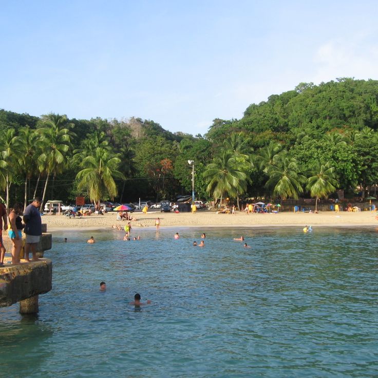
Playa Buye is located on the southwestern coast near Cabo Rojo and represents the kind of accessible beach that Puerto Rico offers beyond its famous destinations. The beach features white sand and shallow, calm water ideal for swimming and families with children. Palm trees provide natural shade over picnic tables where visitors can spend the day comfortably. Basic facilities including restrooms and parking are available, and local vendors occasionally sell snacks and drinks. The protected bay keeps the water gentle year-round.
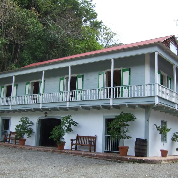
Hacienda Buena Vista in Ponce shows how coffee plantations operated on Puerto Rico in the 19th century. The estate preserves machinery and methods from when the island was one of the world's top coffee producers. Visitors see a water-powered corn mill, drying platforms, and learn from guided tours how coffee beans were harvested and processed. The preserved buildings and functioning equipment reveal the daily life of workers and the island's agricultural history.
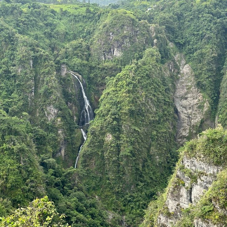
San Cristobal Canyon in the central mountains of Barranquitas and Aibonito offers visitors one of Puerto Rico's many natural features beyond the beaches and colonial sites of San Juan. This canyon has steep rock walls and several waterfalls where rivers flow through the gorge floor, creating a damp environment filled with native plants found only in this location. Various birds and reptiles live in the area. Walking trails along the upper edges provide views down into the canyon. A permit is required to visit since the area is protected for conservation purposes.
Las Delicias Waterfall is part of Puerto Rico's diverse natural landscape discovered within the highland forest of Ciales. The waterfall drops about 80 feet (24 meters) into a natural pool surrounded by tropical growth. Getting there means hiking along trails that wind through thick vegetation, with several viewpoints along the way. The cool water provides relief after the climb. The area remains largely undeveloped, keeping its wild character with dense greenery and minimal facilities.
The Guánica Dry Forest in this collection represents one of Puerto Rico's few remaining dry coastal forests. This protected reserve in the southwestern part of the island shelters plants and animals adapted to arid conditions, including cacti, mahogany trees and thorny scrub. The forest covers a large area with over 50 hiking trails leading to secluded beaches, caves with pre-Columbian carvings and overlooks above the Caribbean Sea. The area holds designation as a UNESCO Biosphere Reserve.
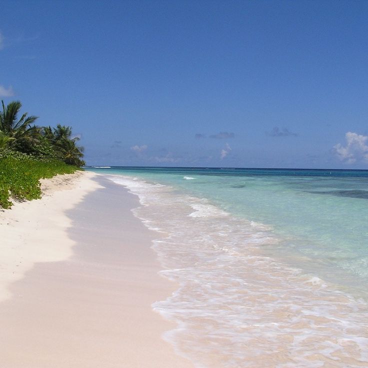
Playa Flamenco sits on the northern coast of Culebra and represents one of the places worth exploring in Puerto Rico beyond the usual tourist spots. The beach stretches about a mile with white sand and clear water suitable for swimming and snorkeling. Coral reefs lie close to shore, hosting tropical fish and sea turtles. At the eastern end, two rusted military tanks from World War II stand as reminders of when the U.S. Navy used the island for target practice. The beach offers basic facilities including restrooms, showers and picnic tables under palm trees. The sheltered bay makes this beach popular with families and day visitors arriving by ferry from Fajardo or small aircraft.
The Punta Tuna Lighthouse has stood on a cliff along the southeastern coast since 1892 and marks one of the critical navigation points in the Caribbean. This 35-meter tower was built to guide vessels through dangerous waters between Puerto Rico and nearby islands. The site includes the original keeper's house and outbuildings from the Spanish colonial period. From this exposed location, you can see wide views of the Caribbean Sea and the rugged coastline.
Charco El Mango is one of the natural swimming pools scattered throughout Puerto Rico that invites discovery beyond the island's famous beaches. Formed by river stones in the central mountains, this pool fills with fresh mountain water and sits surrounded by dense forest. Reaching this secluded spot requires a short hike over uneven ground. Facilities at the site are minimal. Water depth and current vary with rainfall and season.
The Museo Casa Blanca in Vieux San Juan shows how people lived during Puerto Rico's Spanish colonial period. Built in 1521, this building originally served as the home of the Ponce de León family. Inside, visitors walk through rooms filled with furniture and objects from that era, seeing how administrators and their families organized their daily lives. The museum reveals the social structures and domestic habits of colonial society.
La Mina Falls in El Yunque National Forest offers an accessible swimming destination in Puerto Rico. The waterfall drops into a natural pool fed by rainfall and the La Mina River. A paved trail leads through dense tropical rainforest with ferns and bamboo to reach the falls. The path starts at the Palo Colorado Visitor Center and takes only a short walk. Restrooms and changing areas are available near the trailhead.
This beach near Aguadilla draws swimmers and snorkelers with its clear water and the wooden remains of an old military pier that once welcomed supply boats. Below the surface, tropical fish gather between coral formations and rusted anchor chains, while waves at the western end bring more swell. Palm trees offer some shade over the sandy shore, where local families grill food and play music on weekends. In the afternoon the waves pick up and you sometimes see surfers. The water glows turquoise on calm days, and a few food stalls sell fried snacks and cold drinks near the parking area. Lifeguards are sometimes on duty during high season.
The Reserva Natural Cueva del Indio sits on a small island near Arecibo and provides access to limestone caves decorated with precolumbian rock carvings. This cave formation tells the geological story of the region and preserves traces left by the island's original inhabitants. Visitors can explore the caves during low tide, when pools in the rock become accessible. Reaching the island requires a short boat ride from the mainland. The site features rough paths and natural obstacles, but offers a window into Puerto Rico's prehistoric past.
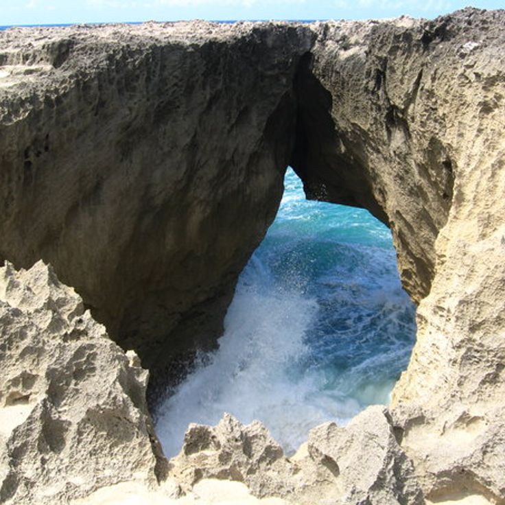
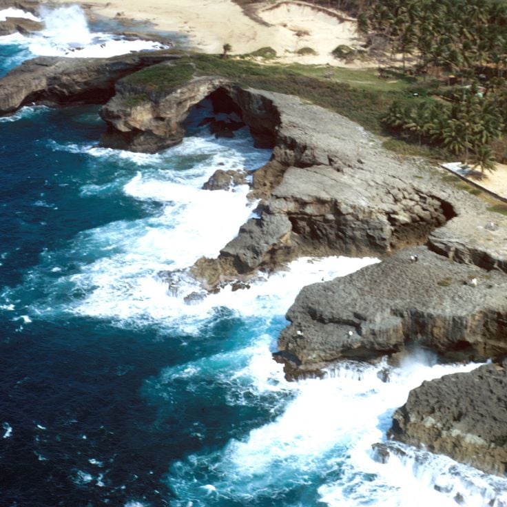
This cave in the northwest of Puerto Rico sits in a coastal zone with limestone formations near Isabela. The entrance opens in a rock wall above sea level and leads into a narrow underground chamber with wet walls. The interior shows geological layers formed over centuries by ocean water and rain. At high tide water enters the lower sections while at low tide dry passages become visible. Visitors reach the site via unpaved paths that sometimes become difficult to pass after heavy rain.
This two-tier waterfall sits inland from San Sebastián and requires a short descent along narrow paths through private land. The upper falls drops about 50 feet (15 meters) into a round pool suitable for swimming, while the lower section features shallower cascades and rocks for sitting. Both areas connect through a slippery path that follows a stream. The water comes from the surrounding forest and flows year-round, though the current calms during the dry season. Local families visit on weekends to picnic and bathe in the natural pools. There is no official supervision, and access involves unpaved roads that can become difficult to navigate after rain.
Charco Azul is a natural freshwater pool within Carite Forest Reserve that offers visitors a chance to swim and explore the island's interior. Reaching the pool requires a hike along a forest trail that winds through the reserve, passing rocks and native vegetation. The water is clear and cold, fed by a nearby stream. The reserve offers several hiking trails and picnic areas for day trips. Weekends bring more people, while weekdays tend to be quieter.
The Punta Borinquen Lighthouse is part of Puerto Rico's collection of sites beyond beaches and colonial fortresses. This white stone structure was built in 1889 on a coastal cliff and continues to serve as a navigation point for vessels crossing the Atlantic. From its elevated position, the lighthouse offers broad views across the ocean and the rugged northwest coast. The site sits on a rocky promontory that has guided mariners for over a century. Visitors can explore the exterior grounds and take in the seaward views, while the historic architecture speaks to Puerto Rico's long maritime heritage.
In the collection of places to discover in Puerto Rico, Cueva Ventana shows one of the limestone caves that shape the northern coast. This cave has a large natural opening that works like a window onto the Arecibo valley. A paved path leads through tropical forest to the cave, where the rock face opens to reveal agricultural plains below. The cave sits about 700 feet (213 meters) above sea level and displays the porous limestone structure that marks this region.
Las Paylas in Luquillo is a natural rock formation in the rainforest where flowing water has smoothed stone into slides that channel streams into a series of connected pools. Over centuries, the current has shaped the surfaces into natural channels where visitors can glide down into the lower basins. The site sits along a stream in the forested area east of Luquillo and requires a hike over a steep and often muddy trail. The pools differ in depth and size, with some deep enough for swimming while others serve as starting points for sliding. Water flow changes depending on recent rainfall, and the rock surfaces can be slippery.
Pozo de Jacinto is a coastal rock formation along Puerto Rico's northern coast where waves force water through small openings to create fountains of spray. This natural pool fits within the collection of places that show the island's diverse geology and the power of ocean forces. Local residents share stories about a shepherd who disappeared at this location, adding layers of local legend to the site. The formation lets ocean water enter through gaps when waves reach sufficient force.
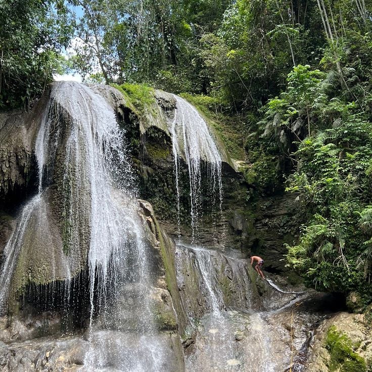
Charco Prieto Waterfall is one of the natural swimming pools found across Puerto Rico. Water cascades over a rocky ledge into a rounded pool surrounded by thick tropical forest. A narrow trail cuts through the forest and takes about 20 minutes to walk. The pool is deep enough for swimming and draws mostly local residents who come to cool off on weekends. Water flows steadily throughout the year but can rise significantly after heavy rain. Sturdy shoes are essential since rocks around the pool become slippery.
This bay in Lajas displays a natural wonder found throughout Puerto Rico's protected waters. The Bahia Bioluminiscente contains millions of dinoflagellates, single-celled organisms that produce blue light when disturbed in the water. The phenomenon becomes visible after dark, when paddles, boats, or swimming motion agitate the plankton and trigger the glow. The bay sits within a mangrove system that maintains the conditions these microorganisms need to thrive. Kayak tours after nightfall let visitors observe the bioluminescence up close.
The salt flats of Cabo Rojo are seawater evaporation ponds that produce salt on Puerto Rico's southwestern coast. The water in these rectangular basins shifts from pink to orange depending on salt levels and sun exposure, colored by microorganisms and minerals. These working salt flats have operated for centuries and spread between the ocean and mangrove forests. Visitors can view the ponds from access roads, though entry to production areas is restricted. The salt flats of Cabo Rojo represent the kind of natural and historical sites that offer visitors more than the beaches and colonial fortresses of San Juan.
Gilligan's Island is part of Puerto Rico's varied natural attractions beyond San Juan. This small cay off the coast of Guánica features protected lagoons with shallow waters for swimming and snorkeling. Mangrove channels surround the island and accessible coral reefs are suitable for kayaking. Visitors reach the island by boat or kayak from the mainland. The calm waters and natural surroundings draw day-trippers year-round.
The Cambalache Forest, a protected reserve south of Arecibo, shows the natural variety of Puerto Rico that goes beyond beaches and colonial sites. This forest features marked trails through subtropical vegetation and displays distinctive limestone formations with hills and sinkholes found on the island's northern coast. Native tree species including various palms and hardwoods fill the canopy. Different bird species make their homes in the dense forest layers. The trails wind through changing vegetation zones and reveal the forest's ecological diversity.
Mar Chiquita is one of the many swimming spots that Puerto Rico offers beyond the famous beaches of San Juan. This natural pool sits on the north coast and is shaped by limestone walls that form a protected cove. Seawater flows through openings in the rock, creating a swimming area with white sand. The water is suitable for swimming when conditions are calm, but waves and currents change with the tides and ocean swells. Local visitors come here to swim and picnic, especially on weekends.
El Cañuelo Fortress was built in 1610 as a Spanish defensive structure to monitor access to San Juan Bay. The stone fortification features guard posts and thick masonry walls facing the Atlantic Ocean. When exploring Puerto Rico, you can visit this fortress while discovering the Spanish fortifications that guarded the harbor entrances across the island.
Cuevas del Indio represents the hidden treasures Puerto Rico offers beyond San Juan's beaches and colonial fortresses. These coastal caves north of Arecibo preserve Taíno rock carvings and limestone formations shaped over centuries by the sea. Visitors follow a path along the cliffs to several interconnected grottos where petroglyphs remain visible on the walls. Waves crash against the rocks, having carved arches and overhangs over time. Access requires sturdy footwear and caution on wet surfaces near the openings. Guided tours explain the significance of the symbols and the geology of the site.
Caja de Muertos Island is one of the places that shows Puerto Rico beyond the beaches and fortresses of San Juan. This uninhabited nature reserve sits off the southern coast and features sandy beaches, dry coastal forest with hiking trails, and a lighthouse built in 1887 on the island's highest point. Visitors can snorkel in designated areas and explore a small museum that documents the island's history. Access is by authorized tour boats departing from Ponce.
Salto Curet sits within the Maricao forest reserve and represents one of the natural waterfalls and swimming pools found throughout Puerto Rico. The waterfall drops over moss-covered rocks into several shallow terraced pools suitable for swimming. A forest trail leads through dense woodland with ferns and bamboo growing along the banks to reach the falls. The path can become slippery after rainfall. The surrounding rainforest shows the wet landscape of western Puerto Rico, contrasting with the drier coastal forests found elsewhere on the island.
This nature reserve is one of the places to discover across Puerto Rico. It protects a coastal landscape with seven different ecosystems, including mangrove forests, coral reefs and lagoons. The lighthouse El Faro dates from 1882 and offers views of the surrounding waters and offshore cays. Laguna Grande is home to microorganisms that emit light when disturbed at night. Trails wind through the mangrove forests and along the coast, where visitors can observe various bird species and marine life.
La Pocita de las Golondrinas is one of the natural swimming pools that defines this guide to Puerto Rico. This tidal pool sits along the northern coast of Manatí where seawater settles between rock formations to create sheltered swimming areas at low tide. The pool sits directly on the Atlantic shoreline and refills with each tide, maintaining constant water circulation. The rock structure offers natural protection from stronger waves and currents. Local swimmers and families have long used this spot for bathing, especially during calmer morning hours and when the water level drops.
La Soplaera Waterfall in Peñuelas is a rewarding discovery for visitors exploring the natural side of Puerto Rico beyond the famous beaches. The waterfall drops 30 meters over weathered rock faces into a shallow pool below, located in the forested upland region of southern Puerto Rico. Reaching it involves hiking on an unpaved trail through dense vegetation and limestone formations. The area has no commercial facilities or developed infrastructure. Sturdy shoes and plenty of water are essential since the path is uneven and shade is sparse in some sections. Water flow depends on rainfall and is strongest during the wet season.
This Indigenous Ceremonial Center in Ponce preserves seven rectangular plazas dating to around 400 CE, making them among the oldest documented ceremonial sites in the Caribbean. The complex displays ball courts, residential areas and burial grounds from the Igneri and Taíno cultures. Visitors can view reconstructed bohíos, examine petroglyphs and see more than 200 skeletal remains along with ceramic artifacts uncovered during excavations since 1975.
Playa Buye is located on the southwestern coast near Cabo Rojo and represents the kind of accessible beach that Puerto Rico offers beyond its famous destinations. The beach features white sand and shallow, calm water ideal for swimming and families with children. Palm trees provide natural shade over picnic tables where visitors can spend the day comfortably. Basic facilities including restrooms and parking are available, and local vendors occasionally sell snacks and drinks. The protected bay keeps the water gentle year-round.
Hacienda Buena Vista in Ponce shows how coffee plantations operated on Puerto Rico in the 19th century. The estate preserves machinery and methods from when the island was one of the world's top coffee producers. Visitors see a water-powered corn mill, drying platforms, and learn from guided tours how coffee beans were harvested and processed. The preserved buildings and functioning equipment reveal the daily life of workers and the island's agricultural history.
San Cristobal Canyon in the central mountains of Barranquitas and Aibonito offers visitors one of Puerto Rico's many natural features beyond the beaches and colonial sites of San Juan. This canyon has steep rock walls and several waterfalls where rivers flow through the gorge floor, creating a damp environment filled with native plants found only in this location. Various birds and reptiles live in the area. Walking trails along the upper edges provide views down into the canyon. A permit is required to visit since the area is protected for conservation purposes.
Las Delicias Waterfall is part of Puerto Rico's diverse natural landscape discovered within the highland forest of Ciales. The waterfall drops about 80 feet (24 meters) into a natural pool surrounded by tropical growth. Getting there means hiking along trails that wind through thick vegetation, with several viewpoints along the way. The cool water provides relief after the climb. The area remains largely undeveloped, keeping its wild character with dense greenery and minimal facilities.
The Guánica Dry Forest in this collection represents one of Puerto Rico's few remaining dry coastal forests. This protected reserve in the southwestern part of the island shelters plants and animals adapted to arid conditions, including cacti, mahogany trees and thorny scrub. The forest covers a large area with over 50 hiking trails leading to secluded beaches, caves with pre-Columbian carvings and overlooks above the Caribbean Sea. The area holds designation as a UNESCO Biosphere Reserve.
Playa Flamenco sits on the northern coast of Culebra and represents one of the places worth exploring in Puerto Rico beyond the usual tourist spots. The beach stretches about a mile with white sand and clear water suitable for swimming and snorkeling. Coral reefs lie close to shore, hosting tropical fish and sea turtles. At the eastern end, two rusted military tanks from World War II stand as reminders of when the U.S. Navy used the island for target practice. The beach offers basic facilities including restrooms, showers and picnic tables under palm trees. The sheltered bay makes this beach popular with families and day visitors arriving by ferry from Fajardo or small aircraft.
The Punta Tuna Lighthouse has stood on a cliff along the southeastern coast since 1892 and marks one of the critical navigation points in the Caribbean. This 35-meter tower was built to guide vessels through dangerous waters between Puerto Rico and nearby islands. The site includes the original keeper's house and outbuildings from the Spanish colonial period. From this exposed location, you can see wide views of the Caribbean Sea and the rugged coastline.
Charco El Mango is one of the natural swimming pools scattered throughout Puerto Rico that invites discovery beyond the island's famous beaches. Formed by river stones in the central mountains, this pool fills with fresh mountain water and sits surrounded by dense forest. Reaching this secluded spot requires a short hike over uneven ground. Facilities at the site are minimal. Water depth and current vary with rainfall and season.
The Museo Casa Blanca in Vieux San Juan shows how people lived during Puerto Rico's Spanish colonial period. Built in 1521, this building originally served as the home of the Ponce de León family. Inside, visitors walk through rooms filled with furniture and objects from that era, seeing how administrators and their families organized their daily lives. The museum reveals the social structures and domestic habits of colonial society.
La Mina Falls in El Yunque National Forest offers an accessible swimming destination in Puerto Rico. The waterfall drops into a natural pool fed by rainfall and the La Mina River. A paved trail leads through dense tropical rainforest with ferns and bamboo to reach the falls. The path starts at the Palo Colorado Visitor Center and takes only a short walk. Restrooms and changing areas are available near the trailhead.
This beach near Aguadilla draws swimmers and snorkelers with its clear water and the wooden remains of an old military pier that once welcomed supply boats. Below the surface, tropical fish gather between coral formations and rusted anchor chains, while waves at the western end bring more swell. Palm trees offer some shade over the sandy shore, where local families grill food and play music on weekends. In the afternoon the waves pick up and you sometimes see surfers. The water glows turquoise on calm days, and a few food stalls sell fried snacks and cold drinks near the parking area. Lifeguards are sometimes on duty during high season.
The Reserva Natural Cueva del Indio sits on a small island near Arecibo and provides access to limestone caves decorated with precolumbian rock carvings. This cave formation tells the geological story of the region and preserves traces left by the island's original inhabitants. Visitors can explore the caves during low tide, when pools in the rock become accessible. Reaching the island requires a short boat ride from the mainland. The site features rough paths and natural obstacles, but offers a window into Puerto Rico's prehistoric past.
This cave in the northwest of Puerto Rico sits in a coastal zone with limestone formations near Isabela. The entrance opens in a rock wall above sea level and leads into a narrow underground chamber with wet walls. The interior shows geological layers formed over centuries by ocean water and rain. At high tide water enters the lower sections while at low tide dry passages become visible. Visitors reach the site via unpaved paths that sometimes become difficult to pass after heavy rain.
This two-tier waterfall sits inland from San Sebastián and requires a short descent along narrow paths through private land. The upper falls drops about 50 feet (15 meters) into a round pool suitable for swimming, while the lower section features shallower cascades and rocks for sitting. Both areas connect through a slippery path that follows a stream. The water comes from the surrounding forest and flows year-round, though the current calms during the dry season. Local families visit on weekends to picnic and bathe in the natural pools. There is no official supervision, and access involves unpaved roads that can become difficult to navigate after rain.
Charco Azul is a natural freshwater pool within Carite Forest Reserve that offers visitors a chance to swim and explore the island's interior. Reaching the pool requires a hike along a forest trail that winds through the reserve, passing rocks and native vegetation. The water is clear and cold, fed by a nearby stream. The reserve offers several hiking trails and picnic areas for day trips. Weekends bring more people, while weekdays tend to be quieter.
The Punta Borinquen Lighthouse is part of Puerto Rico's collection of sites beyond beaches and colonial fortresses. This white stone structure was built in 1889 on a coastal cliff and continues to serve as a navigation point for vessels crossing the Atlantic. From its elevated position, the lighthouse offers broad views across the ocean and the rugged northwest coast. The site sits on a rocky promontory that has guided mariners for over a century. Visitors can explore the exterior grounds and take in the seaward views, while the historic architecture speaks to Puerto Rico's long maritime heritage.
In the collection of places to discover in Puerto Rico, Cueva Ventana shows one of the limestone caves that shape the northern coast. This cave has a large natural opening that works like a window onto the Arecibo valley. A paved path leads through tropical forest to the cave, where the rock face opens to reveal agricultural plains below. The cave sits about 700 feet (213 meters) above sea level and displays the porous limestone structure that marks this region.
Las Paylas in Luquillo is a natural rock formation in the rainforest where flowing water has smoothed stone into slides that channel streams into a series of connected pools. Over centuries, the current has shaped the surfaces into natural channels where visitors can glide down into the lower basins. The site sits along a stream in the forested area east of Luquillo and requires a hike over a steep and often muddy trail. The pools differ in depth and size, with some deep enough for swimming while others serve as starting points for sliding. Water flow changes depending on recent rainfall, and the rock surfaces can be slippery.
Pozo de Jacinto is a coastal rock formation along Puerto Rico's northern coast where waves force water through small openings to create fountains of spray. This natural pool fits within the collection of places that show the island's diverse geology and the power of ocean forces. Local residents share stories about a shepherd who disappeared at this location, adding layers of local legend to the site. The formation lets ocean water enter through gaps when waves reach sufficient force.
Charco Prieto Waterfall is one of the natural swimming pools found across Puerto Rico. Water cascades over a rocky ledge into a rounded pool surrounded by thick tropical forest. A narrow trail cuts through the forest and takes about 20 minutes to walk. The pool is deep enough for swimming and draws mostly local residents who come to cool off on weekends. Water flows steadily throughout the year but can rise significantly after heavy rain. Sturdy shoes are essential since rocks around the pool become slippery.
This bay in Lajas displays a natural wonder found throughout Puerto Rico's protected waters. The Bahia Bioluminiscente contains millions of dinoflagellates, single-celled organisms that produce blue light when disturbed in the water. The phenomenon becomes visible after dark, when paddles, boats, or swimming motion agitate the plankton and trigger the glow. The bay sits within a mangrove system that maintains the conditions these microorganisms need to thrive. Kayak tours after nightfall let visitors observe the bioluminescence up close.
The salt flats of Cabo Rojo are seawater evaporation ponds that produce salt on Puerto Rico's southwestern coast. The water in these rectangular basins shifts from pink to orange depending on salt levels and sun exposure, colored by microorganisms and minerals. These working salt flats have operated for centuries and spread between the ocean and mangrove forests. Visitors can view the ponds from access roads, though entry to production areas is restricted. The salt flats of Cabo Rojo represent the kind of natural and historical sites that offer visitors more than the beaches and colonial fortresses of San Juan.
Gilligan's Island is part of Puerto Rico's varied natural attractions beyond San Juan. This small cay off the coast of Guánica features protected lagoons with shallow waters for swimming and snorkeling. Mangrove channels surround the island and accessible coral reefs are suitable for kayaking. Visitors reach the island by boat or kayak from the mainland. The calm waters and natural surroundings draw day-trippers year-round.
The Cambalache Forest, a protected reserve south of Arecibo, shows the natural variety of Puerto Rico that goes beyond beaches and colonial sites. This forest features marked trails through subtropical vegetation and displays distinctive limestone formations with hills and sinkholes found on the island's northern coast. Native tree species including various palms and hardwoods fill the canopy. Different bird species make their homes in the dense forest layers. The trails wind through changing vegetation zones and reveal the forest's ecological diversity.
Mar Chiquita is one of the many swimming spots that Puerto Rico offers beyond the famous beaches of San Juan. This natural pool sits on the north coast and is shaped by limestone walls that form a protected cove. Seawater flows through openings in the rock, creating a swimming area with white sand. The water is suitable for swimming when conditions are calm, but waves and currents change with the tides and ocean swells. Local visitors come here to swim and picnic, especially on weekends.
El Cañuelo Fortress was built in 1610 as a Spanish defensive structure to monitor access to San Juan Bay. The stone fortification features guard posts and thick masonry walls facing the Atlantic Ocean. When exploring Puerto Rico, you can visit this fortress while discovering the Spanish fortifications that guarded the harbor entrances across the island.
Cuevas del Indio represents the hidden treasures Puerto Rico offers beyond San Juan's beaches and colonial fortresses. These coastal caves north of Arecibo preserve Taíno rock carvings and limestone formations shaped over centuries by the sea. Visitors follow a path along the cliffs to several interconnected grottos where petroglyphs remain visible on the walls. Waves crash against the rocks, having carved arches and overhangs over time. Access requires sturdy footwear and caution on wet surfaces near the openings. Guided tours explain the significance of the symbols and the geology of the site.
Caja de Muertos Island is one of the places that shows Puerto Rico beyond the beaches and fortresses of San Juan. This uninhabited nature reserve sits off the southern coast and features sandy beaches, dry coastal forest with hiking trails, and a lighthouse built in 1887 on the island's highest point. Visitors can snorkel in designated areas and explore a small museum that documents the island's history. Access is by authorized tour boats departing from Ponce.
Salto Curet sits within the Maricao forest reserve and represents one of the natural waterfalls and swimming pools found throughout Puerto Rico. The waterfall drops over moss-covered rocks into several shallow terraced pools suitable for swimming. A forest trail leads through dense woodland with ferns and bamboo growing along the banks to reach the falls. The path can become slippery after rainfall. The surrounding rainforest shows the wet landscape of western Puerto Rico, contrasting with the drier coastal forests found elsewhere on the island.
This nature reserve is one of the places to discover across Puerto Rico. It protects a coastal landscape with seven different ecosystems, including mangrove forests, coral reefs and lagoons. The lighthouse El Faro dates from 1882 and offers views of the surrounding waters and offshore cays. Laguna Grande is home to microorganisms that emit light when disturbed at night. Trails wind through the mangrove forests and along the coast, where visitors can observe various bird species and marine life.
La Pocita de las Golondrinas is one of the natural swimming pools that defines this guide to Puerto Rico. This tidal pool sits along the northern coast of Manatí where seawater settles between rock formations to create sheltered swimming areas at low tide. The pool sits directly on the Atlantic shoreline and refills with each tide, maintaining constant water circulation. The rock structure offers natural protection from stronger waves and currents. Local swimmers and families have long used this spot for bathing, especially during calmer morning hours and when the water level drops.
La Soplaera Waterfall in Peñuelas is a rewarding discovery for visitors exploring the natural side of Puerto Rico beyond the famous beaches. The waterfall drops 30 meters over weathered rock faces into a shallow pool below, located in the forested upland region of southern Puerto Rico. Reaching it involves hiking on an unpaved trail through dense vegetation and limestone formations. The area has no commercial facilities or developed infrastructure. Sturdy shoes and plenty of water are essential since the path is uneven and shade is sparse in some sections. Water flow depends on rainfall and is strongest during the wet season.
This Indigenous Ceremonial Center in Ponce preserves seven rectangular plazas dating to around 400 CE, making them among the oldest documented ceremonial sites in the Caribbean. The complex displays ball courts, residential areas and burial grounds from the Igneri and Taíno cultures. Visitors can view reconstructed bohíos, examine petroglyphs and see more than 200 skeletal remains along with ceramic artifacts uncovered during excavations since 1975.
Playa Buye is located on the southwestern coast near Cabo Rojo and represents the kind of accessible beach that Puerto Rico offers beyond its famous destinations. The beach features white sand and shallow, calm water ideal for swimming and families with children. Palm trees provide natural shade over picnic tables where visitors can spend the day comfortably. Basic facilities including restrooms and parking are available, and local vendors occasionally sell snacks and drinks. The protected bay keeps the water gentle year-round.
Hacienda Buena Vista in Ponce shows how coffee plantations operated on Puerto Rico in the 19th century. The estate preserves machinery and methods from when the island was one of the world's top coffee producers. Visitors see a water-powered corn mill, drying platforms, and learn from guided tours how coffee beans were harvested and processed. The preserved buildings and functioning equipment reveal the daily life of workers and the island's agricultural history.
San Cristobal Canyon in the central mountains of Barranquitas and Aibonito offers visitors one of Puerto Rico's many natural features beyond the beaches and colonial sites of San Juan. This canyon has steep rock walls and several waterfalls where rivers flow through the gorge floor, creating a damp environment filled with native plants found only in this location. Various birds and reptiles live in the area. Walking trails along the upper edges provide views down into the canyon. A permit is required to visit since the area is protected for conservation purposes.
Las Delicias Waterfall is part of Puerto Rico's diverse natural landscape discovered within the highland forest of Ciales. The waterfall drops about 80 feet (24 meters) into a natural pool surrounded by tropical growth. Getting there means hiking along trails that wind through thick vegetation, with several viewpoints along the way. The cool water provides relief after the climb. The area remains largely undeveloped, keeping its wild character with dense greenery and minimal facilities.
The Guánica Dry Forest in this collection represents one of Puerto Rico's few remaining dry coastal forests. This protected reserve in the southwestern part of the island shelters plants and animals adapted to arid conditions, including cacti, mahogany trees and thorny scrub. The forest covers a large area with over 50 hiking trails leading to secluded beaches, caves with pre-Columbian carvings and overlooks above the Caribbean Sea. The area holds designation as a UNESCO Biosphere Reserve.
Playa Flamenco sits on the northern coast of Culebra and represents one of the places worth exploring in Puerto Rico beyond the usual tourist spots. The beach stretches about a mile with white sand and clear water suitable for swimming and snorkeling. Coral reefs lie close to shore, hosting tropical fish and sea turtles. At the eastern end, two rusted military tanks from World War II stand as reminders of when the U.S. Navy used the island for target practice. The beach offers basic facilities including restrooms, showers and picnic tables under palm trees. The sheltered bay makes this beach popular with families and day visitors arriving by ferry from Fajardo or small aircraft.
The Punta Tuna Lighthouse has stood on a cliff along the southeastern coast since 1892 and marks one of the critical navigation points in the Caribbean. This 35-meter tower was built to guide vessels through dangerous waters between Puerto Rico and nearby islands. The site includes the original keeper's house and outbuildings from the Spanish colonial period. From this exposed location, you can see wide views of the Caribbean Sea and the rugged coastline.
Charco El Mango is one of the natural swimming pools scattered throughout Puerto Rico that invites discovery beyond the island's famous beaches. Formed by river stones in the central mountains, this pool fills with fresh mountain water and sits surrounded by dense forest. Reaching this secluded spot requires a short hike over uneven ground. Facilities at the site are minimal. Water depth and current vary with rainfall and season.
The Museo Casa Blanca in Vieux San Juan shows how people lived during Puerto Rico's Spanish colonial period. Built in 1521, this building originally served as the home of the Ponce de León family. Inside, visitors walk through rooms filled with furniture and objects from that era, seeing how administrators and their families organized their daily lives. The museum reveals the social structures and domestic habits of colonial society.
La Mina Falls in El Yunque National Forest offers an accessible swimming destination in Puerto Rico. The waterfall drops into a natural pool fed by rainfall and the La Mina River. A paved trail leads through dense tropical rainforest with ferns and bamboo to reach the falls. The path starts at the Palo Colorado Visitor Center and takes only a short walk. Restrooms and changing areas are available near the trailhead.
This beach near Aguadilla draws swimmers and snorkelers with its clear water and the wooden remains of an old military pier that once welcomed supply boats. Below the surface, tropical fish gather between coral formations and rusted anchor chains, while waves at the western end bring more swell. Palm trees offer some shade over the sandy shore, where local families grill food and play music on weekends. In the afternoon the waves pick up and you sometimes see surfers. The water glows turquoise on calm days, and a few food stalls sell fried snacks and cold drinks near the parking area. Lifeguards are sometimes on duty during high season.
The Reserva Natural Cueva del Indio sits on a small island near Arecibo and provides access to limestone caves decorated with precolumbian rock carvings. This cave formation tells the geological story of the region and preserves traces left by the island's original inhabitants. Visitors can explore the caves during low tide, when pools in the rock become accessible. Reaching the island requires a short boat ride from the mainland. The site features rough paths and natural obstacles, but offers a window into Puerto Rico's prehistoric past.
This cave in the northwest of Puerto Rico sits in a coastal zone with limestone formations near Isabela. The entrance opens in a rock wall above sea level and leads into a narrow underground chamber with wet walls. The interior shows geological layers formed over centuries by ocean water and rain. At high tide water enters the lower sections while at low tide dry passages become visible. Visitors reach the site via unpaved paths that sometimes become difficult to pass after heavy rain.
This two-tier waterfall sits inland from San Sebastián and requires a short descent along narrow paths through private land. The upper falls drops about 50 feet (15 meters) into a round pool suitable for swimming, while the lower section features shallower cascades and rocks for sitting. Both areas connect through a slippery path that follows a stream. The water comes from the surrounding forest and flows year-round, though the current calms during the dry season. Local families visit on weekends to picnic and bathe in the natural pools. There is no official supervision, and access involves unpaved roads that can become difficult to navigate after rain.