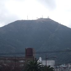
Mount Fukuchi, Mountain summit in Kokuraminami-ku, Japan.
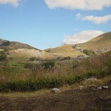
Mount Fukuchi is a mountain summit in the Chikuho region of Fukuoka Prefecture, rising to around 900 meters and covered by dense forest. Several hiking trails run across its slopes, connecting the surrounding towns of Nogata and Fukuchi.
During the Edo period, the mountain served as a natural boundary between territories under the Kokura Domain. That boundary role persisted through later administrative changes and still shapes the division between the municipalities on either side.
A small Shinto shrine sits near the summit, and many hikers stop there after reaching the top. Mountaintop shrines like this one are common in Japan, reflecting the long-held belief that high places carry a special spiritual presence.
A parking area at the base gives easy access to the trailheads, so a car is the most practical way to get there. The paths are clearly marked and manageable for most walkers, though sturdy footwear is a good idea given the forest terrain.
Although the mountain is administratively part of Fukuchi, its summit sits precisely on the boundary with Nogata, meaning hikers can stand with one foot in each municipality. This makes it one of the few places in the area where two towns literally meet at a single point.
The community of curious travelers
AroundUs brings together thousands of curated places, local tips, and hidden gems, enriched daily by 60,000 contributors worldwide.