Enable Location

We need your location to show you interesting places around you

Discover nearby places

Find interesting locations and hidden gems around you

Precise directions

Get accurate directions and distances to places

Your location is never shared with other users. It's only used when you tap the location button.

Shorian National Park

Log in to your account

Start exploring — it's free

Trusted by 61,659 travelers worldwide

Continue with Google
Continue with Apple
or

We will send you a code to connect

By continuing, you accept our Terms and Conditions and our Privacy Policy

Check your inbox

We've sent a pincode in your inbox. Please enter the code below.

Shorian National Park, Protected mountain area in Kemerovo region, Russia.

Description

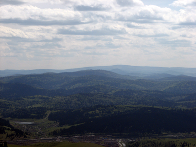
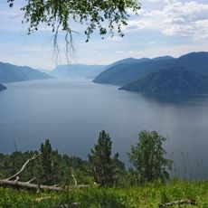
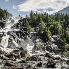
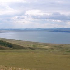
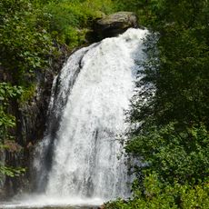
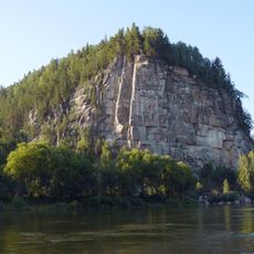
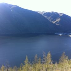
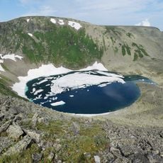
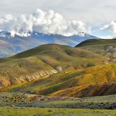
Shorian National Park extends across 166,000 hectares with dense forests, granite outcrops, rivers, and mountains, with Kubez Peak reaching around 1,555 meters at its highest point. The landscape features karst formations containing limestone caves, natural springs, and unusual rock structures within the Sayan montane conifer forests.

History

Shorian National Park was established in 1989, ending extensive logging operations in the region. This creation allowed mature forest ecosystems to regenerate naturally after years of heavy use.

Culture

The territory has been home to the Shor people for generations, known for their traditional iron-smelting techniques and shamanic practices. These traditions continue to shape how local communities relate to the land and its resources.

Practical

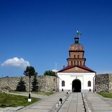
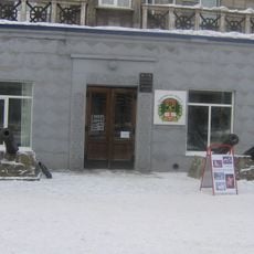
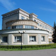
Access to the park is managed from the headquarters in Tashtagol, where visitors obtain entry permits and can arrange guided tours. The area offers options for hiking, horseback riding, climbing, and river activities depending on the season and local conditions.

Did you know?

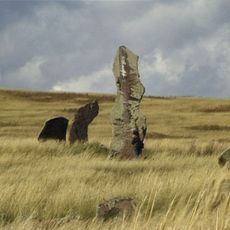
The area contains rare karst phenomena with caves and natural springs emerging from limestone, creating striking features in the rocky landscape. These geological peculiarities make the park a place where visitors encounter layers of natural history written in stone.

Location
Inception
December 27, 1989
GPS coordinates
52.58333,88.33333
Latest update
December 8, 2025 20:01

AroundUs brings together thousands of curated places, local tips, and hidden gems, enriched daily by 60,000 contributors worldwide. Discover all places nearby (Kemerovo Oblast).

Around this place
Teletskoe
Russian Federation

Teletskoe

124.8 km
Altai Nature Reserve
Russian Federation

Altai Nature Reserve

74.5 km
Kuznetsk Fortress
Russian Federation

Kuznetsk Fortress

153.2 km
Khakasski Nature Reserve
Russian Federation

Khakasski Nature Reserve

82 km
Kuznetsk Metallurgists Sports Palace
Russian Federation

Kuznetsk Metallurgists Sports Palace

154.9 km
Novokuznetsk Drama Theatre
Russian Federation

Novokuznetsk Drama Theatre

153.7 km
Korbu Waterfall
Russian Federation

Korbu Waterfall

107.2 km
Transfiguration Cathedral, Novokuznetsk
Russian Federation

Transfiguration Cathedral, Novokuznetsk

152.7 km
Church of the Nativity of Jesus Christ in Novokuznetsk
Russian Federation

Church of the Nativity of Jesus Christ in Novokuznetsk

149.6 km
Statue of Vladimir Mayakovsky in Novokuznetsk
Russian Federation

Statue of Vladimir Mayakovsky in Novokuznetsk

154.3 km
Iconostas cliff
Russian Federation

Iconostas cliff

95.5 km
St. John Chrysostom Church, Novokuznetsk
Russian Federation

St. John Chrysostom Church, Novokuznetsk

150 km
Metallurgists' Garden
Russian Federation

Metallurgists' Garden

153.6 km
Musée ethnographique régional de Novokouznetski
Russian Federation

Musée ethnographique régional de Novokouznetski

154.1 km
Metallurg Stadium, Novokuznetsk
Russian Federation

Metallurg Stadium, Novokuznetsk

154.7 km
Kommunar Cinema, Novokuznetsk
Russian Federation

Kommunar Cinema, Novokuznetsk

153.5 km
Кузнецкий мост (Новокузнецк)
Russian Federation

Кузнецкий мост (Новокузнецк)

152.3 km
Kara-Khol
Russian Federation

Kara-Khol

152.1 km
Safronovsky burial ground
Russian Federation

Safronovsky burial ground

127.6 km
Novokuznetsk Art Museum
Russian Federation

Novokuznetsk Art Museum

152.7 km
Большая Кольтайга
Russian Federation

Большая Кольтайга

64.2 km
Байдаевский мост
Russian Federation

Байдаевский мост

149.3 km
Սուրբ Գրիգոր Լուսավորիչ եկեղեցի (Սոսնովկա)
Russian Federation

Սուրբ Գրիգոր Լուսավորիչ եկեղեցի (Սոսնովկա)

144 km
Здание уездного училища (Новокузнецк)
Russian Federation

Здание уездного училища (Новокузнецк)

152.4 km
527 km
Russian Federation

527 km

67.7 km
Saylyugemsky National Park
Russian Federation

Saylyugemsky National Park

18 km
Аквапарк "Лагуна"
Russian Federation

Аквапарк "Лагуна"

154.2 km
Palace of Metallurgists
Russian Federation

Palace of Metallurgists

153.7 km
Show the full map
« Shorian National Park - Protected mountain area in Kemerovo region, Russia » is provided by Around Us (aroundus.com). Images and texts are derived from Wikimedia project under a Creative Commons license. You are allowed to copy, distribute, and modify copies of this page, under the conditions set by the license, as long as this note is clearly visible.

Discover hidden gems everywhere you go!

From secret cafés to breathtaking viewpoints, skip the crowded tourist spots and find places that match your style. Our app makes it easy with voice search, smart filtering, route optimization, and insider tips from travelers worldwide. Download now for the complete mobile experience.

Around Us App Screenshot

A unique approach to discovering new places

Le Figaro

All the places worth exploring

France Info

A tailor-made excursion in just a few clicks

20 Minutes

Around Us
Travel Guide & Maps
Download

Send to your phone

QR Code
1

Open the camera app on your mobile.

2

Point at the QR code with your camera. A notification will appear.

3

Tap the notification to open the link.