Chest opened
+${chestReward.xp} XP
Explorer
NOUVEAU ×${chestReward.collectible.quantity}
tapez pour fermer
Chest locked

Open chests in the app

Around Us is built for your phone — chests unlock when you walk, explore and capture nearby places.

Enable Location

We need your location to show you interesting places around you

Discover nearby places

Find interesting locations and hidden gems around you

Precise directions

Get accurate directions and distances to places

Your location is never shared with other users. It's only used when you tap the location button.

Log in to your account

Start exploring — it's free

Trusted by 72,884 travelers worldwide

Continue with Google
Continue with Apple
or

We will send you a code to connect

By continuing, you accept our Terms and Conditions and our Privacy Policy

Check your inbox

We've sent a pincode in your inbox. Please enter the code below.

Gull Island Light
Discussion Reviews Photo
1.2k Popularity

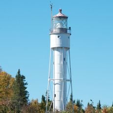
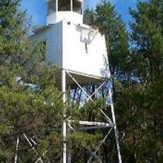
Gull Island Light, Navigation aid on Gull Island in Lake Superior, Wisconsin, US.

Gull Island Light is a skeletal lighthouse made of black iron located on an island in Lake Superior, Wisconsin. The pyramidal structure stands approximately 50 feet tall and serves to guide vessels through the lake's waters safely.

Congress authorized construction of this lighthouse in 1928 following repeated requests to improve navigation safety in the area. It was built to address the hazards vessels encountered in this section of Lake Superior.

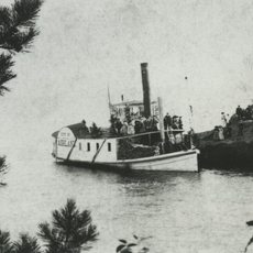
The lighthouse stands as part of the maritime infrastructure network in the Apostle Islands region, marking the evolution of Great Lakes navigation systems.

The light flashes every two and a half seconds and remains visible for about 7 nautical miles, making it a reliable navigation marker for passing vessels. A solar-powered system operates the optic, requiring minimal maintenance despite the remote island location.

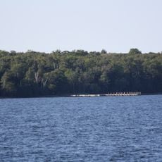
A submerged rocky ledge extends several kilometers from the island beneath the lake's surface, posing a significant hazard to vessels. This underwater obstacle is the primary reason why this navigation aid remains essential for safe passage through the area.

The community of curious travelers

AroundUs brings together thousands of curated places, local tips, and hidden gems, enriched daily by 60,000 contributors worldwide.

Start exploring
Location
Height
15 m
GPS coordinates
46.90686,-90.44333
Latest update
December 14, 2025 18:47
Around this place
Big Bay State Park
United States of America

Big Bay State Park

21.1 km
SS Ira H. Owen
United States of America

SS Ira H. Owen

26.1 km
Apostle Islands Lighthouses
United States of America

Apostle Islands Lighthouses

15.4 km
Michigan Island Light
United States of America

Michigan Island Light

5.7 km
Devils Island Light
United States of America

Devils Island Light

28.9 km
Superior Falls
United States of America

Superior Falls

38.4 km
Gaylord Nelson Wilderness
United States of America

Gaylord Nelson Wilderness

18 km
Raspberry Island Light
United States of America

Raspberry Island Light

28.4 km
Sand Island Light
United States of America

Sand Island Light

39 km
Outer Island Light
United States of America

Outer Island Light

19 km
La Pointe Light
United States of America

La Pointe Light

32.7 km
United States of America

Kakagon Sloughs

35.4 km
Madeline Island Historical Museum
United States of America

Madeline Island Historical Museum

29.8 km
Old Bayfield County Courthouse
United States of America

Old Bayfield County Courthouse

30.5 km
Bass Island Brownstone Company Quarry
United States of America

Bass Island Brownstone Company Quarry

25.2 km
Chequamegon Point Light
United States of America

Chequamegon Point Light

34.2 km
Manitou Camp
United States of America

Manitou Camp

18.5 km
Frank Boutin, Jr. House
United States of America

Frank Boutin, Jr. House

30.1 km
Bayfield Fish Hatchery
United States of America

Bayfield Fish Hatchery

34.7 km
Christ Episcopal Church
United States of America

Christ Episcopal Church

30.4 km
Hadland Fishing Camp
United States of America

Hadland Fishing Camp

22.8 km
City of Ashland
United States of America

City of Ashland

38.2 km
Rocky Island Historic District
United States of America

Rocky Island Historic District

22.9 km
Sevona Cabin
United States of America

Sevona Cabin

38.1 km
Bayfield Historic District
United States of America

Bayfield Historic District

30.3 km
Madeline Island
United States of America

Madeline Island

29.8 km
Bayview Beach
United States of America

Bayview Beach

38 km
Madeline Island Public Library
United States of America

Madeline Island Public Library

29.7 km
Show the full map
Reviews
Share your experience

No review yet

Discussions
Start a discussion...

No discussion yet

« Gull Island Light - Navigation aid on Gull Island in Lake Superior, Wisconsin, US » is provided by Around Us (aroundus.com). Images and texts are derived from Wikimedia project under a Creative Commons license. You are allowed to copy, distribute, and modify copies of this page, under the conditions set by the license, as long as this note is clearly visible.

Discover hidden gems everywhere you go!

From secret cafés to breathtaking viewpoints, skip the crowded tourist spots and find places that match your style. Our app makes it easy with voice search, smart filtering, route optimization, and insider tips from travelers worldwide. Download now for the complete mobile experience.

Around Us App Screenshot

A unique approach to discovering new places

Le Figaro

All the places worth exploring

France Info

A tailor-made excursion in just a few clicks

20 Minutes

Around Us
Travel Guide & Maps
Download

Send to your phone

QR Code
1

Open the camera app on your mobile.

2

Point at the QR code with your camera. A notification will appear.

3

Tap the notification to open the link.