Enable Location

We need your location to show you interesting places around you

Discover nearby places

Find interesting locations and hidden gems around you

Precise directions

Get accurate directions and distances to places

Your location is never shared with other users. It's only used when you tap the location button.

Devils Island Light

Log in to your account

Start exploring — it's free

Trusted by 61,355 travelers worldwide

Continue with Google
Continue with Apple
or

We will send you a code to connect

By continuing, you accept our Terms and Conditions and our Privacy Policy

Check your inbox

We've sent a pincode in your inbox. Please enter the code below.

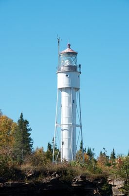
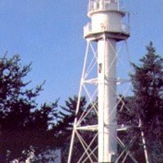
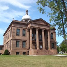
Devils Island Light, Navigation lighthouse on Devils Island, Lake Superior, US.

Description

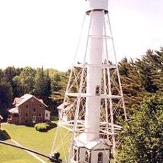
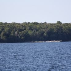
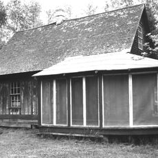
Devils Island Light is a cylindrical tower made of cast iron, about 22 meters tall, standing on the northern shore of the island in Lake Superior. The site includes keeper's dwellings, oil houses, a tramway, and a radio beacon tower.

History

Congress authorized funds for the project in 1889, and the tower began operating in 1901. It was the last of eight lighthouses built in the Apostle Islands.

Culture

The lighthouse holds its original Fresnel lens, which guided ships across the lake with red light signals. This equipment shows how people once kept navigation safe on large bodies of water.

Practical

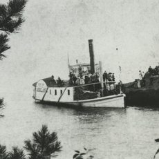
The site is accessible by water taxi during summer months from the island. Visitors should prepare for changeable weather and rough conditions on the lake.

Did you know?

President Calvin Coolidge and the First Lady visited the site during a vacation in Wisconsin in September 1928. This visit left a lasting mark on the local history of the place.

Location
Height
22 m
Made from material
cast iron
Part of
Apostle Islands Lighthouses
GPS coordinates
47.07947,-90.72831
Latest update
December 13, 2025 12:24

AroundUs brings together thousands of curated places, local tips, and hidden gems, enriched daily by 60,000 contributors worldwide. Discover all places nearby (Ashland County).

Around this place
Palisade Head
United States of America

Palisade Head

45.5 km
Tettegouche State Park
United States of America

Tettegouche State Park

45.6 km
Big Bay State Park
United States of America

Big Bay State Park

31.4 km
Apostle Islands Lighthouses
United States of America

Apostle Islands Lighthouses

13.5 km
Michigan Island Light
United States of America

Michigan Island Light

29.1 km
Gaylord Nelson Wilderness
United States of America

Gaylord Nelson Wilderness

13.6 km
Raspberry Island Light
United States of America

Raspberry Island Light

13.4 km
Sand Island Light
United States of America

Sand Island Light

18 km
Outer Island Light
United States of America

Outer Island Light

23.6 km
La Pointe Light
United States of America

La Pointe Light

39.3 km
United States of America

Kakagon Sloughs

46.5 km
Madeline Island Historical Museum
United States of America

Madeline Island Historical Museum

33.6 km
Old Bayfield County Courthouse
United States of America

Old Bayfield County Courthouse

30.5 km
Bass Island Brownstone Company Quarry
United States of America

Bass Island Brownstone Company Quarry

27.6 km
Chequamegon Point Light
United States of America

Chequamegon Point Light

39.5 km
Manitou Camp
United States of America

Manitou Camp

14.3 km
Frank Boutin, Jr. House
United States of America

Frank Boutin, Jr. House

30.3 km
Bayfield Fish Hatchery
United States of America

Bayfield Fish Hatchery

34.2 km
Christ Episcopal Church
United States of America

Christ Episcopal Church

30.5 km
Bayfield County Courthouse
United States of America

Bayfield County Courthouse

46.5 km
Hadland Fishing Camp
United States of America

Hadland Fishing Camp

6.2 km
City of Ashland
United States of America

City of Ashland

44.5 km
Rocky Island Historic District
United States of America

Rocky Island Historic District

6 km
Sevona Cabin
United States of America

Sevona Cabin

20.4 km
East Third Street Residential Historic District
United States of America

East Third Street Residential Historic District

46.6 km
Bayfield Historic District
United States of America

Bayfield Historic District

30.6 km
Apostle Islands Ice Caves
United States of America

Apostle Islands Ice Caves

32.7 km
Madeline Island
United States of America

Madeline Island

33.6 km
Show the full map
« Devils Island Light - Navigation lighthouse on Devils Island, Lake Superior, US » is provided by Around Us (aroundus.com). Images and texts are derived from Wikimedia project under a Creative Commons license. You are allowed to copy, distribute, and modify copies of this page, under the conditions set by the license, as long as this note is clearly visible.

Discover hidden gems everywhere you go!

From secret cafés to breathtaking viewpoints, skip the crowded tourist spots and find places that match your style. Our app makes it easy with voice search, smart filtering, route optimization, and insider tips from travelers worldwide. Download now for the complete mobile experience.

Around Us App Screenshot

A unique approach to discovering new places

Le Figaro

All the places worth exploring

France Info

A tailor-made excursion in just a few clicks

20 Minutes

Around Us
Travel Guide & Maps
Download

Send to your phone

QR Code
1

Open the camera app on your mobile.

2

Point at the QR code with your camera. A notification will appear.

3

Tap the notification to open the link.