Kumbrabow State Forest

Log in to your account

AroundUs is a community-driven map of interesting places, built by curious explorers like you. It grows with every review, story, and photo you share.
Connect to save your favorite spots, contribute locations, and create personalized routes.
By continuing, you accept our Terms and Conditions and our Privacy Policy
Add to collection
Map
Suggest a change
Share

Kumbrabow State Forest, State forest in Randolph County, United States.

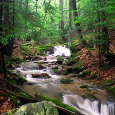
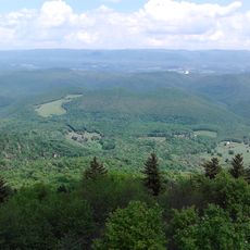
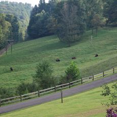
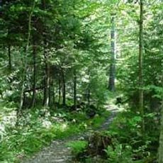
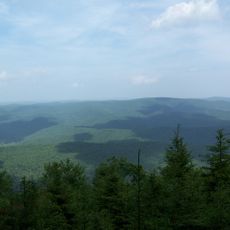
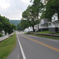
Kumbrabow State Forest is a woodland reserve in the Appalachian region that spreads across Rich Mountain with varied elevations from deep valleys to over 3,000 feet. The terrain shows gentle mountain ridges with mixed forest, creeks, some open areas, and a network of trails winding through the property.

The forest was established in 1934 when the land was acquired and protected to preserve the mountain region. The name comes from three local families - Kump, Brady, and Bowers - who played a key role in its founding.

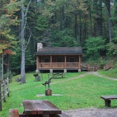
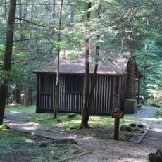
The Civilian Conservation Corps constructed pioneer cabins with stone fireplaces during the 1930s, preserving traditional mountain architecture within the forest grounds.

Mill Creek Campground offers thirteen camping sites with picnic tables, fire pits, and shower facilities for guests. The area is suitable for brook trout fishing, and trails are well marked for walks of varying difficulty.

The area contains several log cabins with stone fireplaces built by the Civilian Conservation Corps in the 1930s that showcase traditional mountain building methods. These structures remain visible and speak to craftsmanship from that era.

Location: West Virginia

Elevation above the sea: 1,080 m

Website: https://wvstateparks.com/park/kumbrabo-state-forest

GPS coordinates: 38.63860,-80.09830

Latest update: December 13, 2025 17:10

Photos
Around this place
Green Bank Telescope
United States of America

Green Bank Telescope

32.1 km
Cass Scenic Railroad State Park
United States of America

Cass Scenic Railroad State Park

31.3 km
Durbin and Greenbrier Valley Railroad
United States of America

Durbin and Greenbrier Valley Railroad

25.4 km
Holly River State Park
United States of America

Holly River State Park

20.1 km
Bald Knob
United States of America

Bald Knob

25.8 km
West Virginia State Wildlife Center
United States of America

West Virginia State Wildlife Center

30.4 km
Green Bank Interferometer
United States of America

Green Bank Interferometer

32.1 km
White Top
United States of America

White Top

19.3 km
Gaudineer Scenic Area
United States of America

Gaudineer Scenic Area

22.3 km
Gaudineer Knob
United States of America

Gaudineer Knob

22.2 km
40-foot telescope
United States of America

40-foot telescope

32.3 km
Middle Mountain Cabins
United States of America

Middle Mountain Cabins

32.1 km
Tygart Valley Homesteads Historic District
United States of America

Tygart Valley Homesteads Historic District

22.7 km
Shavers Fork Mountain Complex
United States of America

Shavers Fork Mountain Complex

22.3 km
Camp Bartow Historic District
United States of America

Camp Bartow Historic District

31 km
Helvetia Village Historic District
United States of America

Helvetia Village Historic District

11.8 km
Morton House
United States of America

Morton House

32.5 km
E. E. Hutton House
United States of America

E. E. Hutton House

13.4 km
Fidler's Mill
United States of America

Fidler's Mill

21.3 km
Cass Historic District
United States of America

Cass Historic District

31.6 km
Beverly Historic District
United States of America

Beverly Historic District

29.8 km
Butcher Hill Historic District
United States of America

Butcher Hill Historic District

30.3 km
Blackman-Bosworth Store
United States of America

Blackman-Bosworth Store

29.7 km
Green Bank Observatory
United States of America

Green Bank Observatory

31.9 km
300 foot Radio Telescope
United States of America

300 foot Radio Telescope

32.1 km
Beverly Heritage Center
United States of America

Beverly Heritage Center

29.7 km
Green Bank 85-3 telescope
United States of America

Green Bank 85-3 telescope

32.2 km
New Deal Resources in Holly River State Park Historic District
United States of America

New Deal Resources in Holly River State Park Historic District

23 km
Show the full map
Reviews

Visited this place? Tap the stars to rate it and share your experience / photos with the community! Try now! You can cancel it anytime.

« Kumbrabow State Forest - State forest in Randolph County, United States » is provided by Around Us (aroundus.com). Images and texts are derived from Wikimedia project under a Creative Commons license. You are allowed to copy, distribute, and modify copies of this page, under the conditions set by the license, as long as this note is clearly visible.

Discover hidden gems everywhere you go!

From secret cafés to breathtaking viewpoints, skip the crowded tourist spots and find places that match your style. Our app makes it easy with voice search, smart filtering, route optimization, and insider tips from travelers worldwide. Download now for the complete mobile experience.

Around Us App Screenshot

A unique approach to discovering new places

Le Figaro

All the places worth exploring

France Info

A tailor-made excursion in just a few clicks

20 Minutes