Enable Location

We need your location to show you interesting places around you

Discover nearby places

Find interesting locations and hidden gems around you

Precise directions

Get accurate directions and distances to places

Your location is never shared with other users. It's only used when you tap the location button.

Martin Olav Sabo Bridge

Log in to your account

Start exploring — it's free

Trusted by 65,063 travelers worldwide

Continue with Google
Continue with Apple
or

We will send you a code to connect

By continuing, you accept our Terms and Conditions and our Privacy Policy

Check your inbox

We've sent a pincode in your inbox. Please enter the code below.

Martin Olav Sabo Bridge
Discussion Reviews 1 Photos
3.3k Popularity

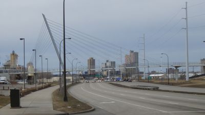
Martin Olav Sabo Bridge, Cable-stayed pedestrian bridge in Phillips neighborhood, Minneapolis, United States

The Martin Olav Sabo Bridge is a cable-stayed footbridge in Minneapolis that crosses over Hiawatha Avenue and the METRO Blue Line light rail tracks. It links several neighborhoods on either side and gives people on foot or on a bike a direct path without crossing any traffic signals.

The bridge opened in 2007 as a new crossing connecting neighborhoods that had previously been separated by the avenue and the rail line. Some years later, problems with the cable system led to repairs and a temporary closure before the bridge reopened to the public.

The bridge takes its name from Martin Olav Sabo, a Minnesota congressman who personally pushed for the project to receive federal funding. Today it is a crossing that people from nearby neighborhoods use daily, on foot or by bike, as a direct connection through the city.

The bridge is easy to reach on foot or by bike, and the path across is flat and straightforward with no major inclines. Those traveling with wide cargo bikes or large objects should be aware that the usable width of the crossing is limited.

The bridge's single tower rises about 100 feet (30 meters) and its steel cables are anchored directly into the limestone bedrock beneath the street, which was an uncommon approach in Minnesota at the time it was built. This anchoring method was chosen specifically to handle the wide span over both the road and the rail tracks below.

The community of curious travelers

AroundUs brings together thousands of curated places, local tips, and hidden gems, enriched daily by 60,000 contributors worldwide.

Start exploring
Location
Inception
November 8, 2007
Official opening
November 8, 2007
GPS coordinates
44.95470,-93.24250
Latest update
March 3, 2026 13:58
Around this place
Show the full map
Reviews
Share your experience

No review yet

Discussions
Start a discussion...

No discussion yet

« Martin Olav Sabo Bridge - Cable-stayed pedestrian bridge in Phillips neighborhood, Minneapolis, United States » is provided by Around Us (aroundus.com). Images and texts are derived from Wikimedia project under a Creative Commons license. You are allowed to copy, distribute, and modify copies of this page, under the conditions set by the license, as long as this note is clearly visible.

Discover hidden gems everywhere you go!

From secret cafés to breathtaking viewpoints, skip the crowded tourist spots and find places that match your style. Our app makes it easy with voice search, smart filtering, route optimization, and insider tips from travelers worldwide. Download now for the complete mobile experience.

Around Us App Screenshot

A unique approach to discovering new places

Le Figaro

All the places worth exploring

France Info

A tailor-made excursion in just a few clicks

20 Minutes

Around Us
Travel Guide & Maps
Download

Send to your phone

QR Code
1

Open the camera app on your mobile.

2

Point at the QR code with your camera. A notification will appear.

3

Tap the notification to open the link.