Enable Location

We need your location to show you interesting places around you

Discover nearby places

Find interesting locations and hidden gems around you

Precise directions

Get accurate directions and distances to places

Your location is never shared with other users. It's only used when you tap the location button.

Dartmouth Bridge

Log in to your account

Start exploring — it's free

Trusted by 62,937 travelers worldwide

Continue with Google
Continue with Apple
or

We will send you a code to connect

By continuing, you accept our Terms and Conditions and our Privacy Policy

Check your inbox

We've sent a pincode in your inbox. Please enter the code below.

Dartmouth Bridge
Discussion Reviews 1 Photos
1.5k Popularity

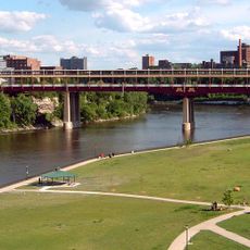
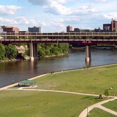
Dartmouth Bridge, Steel road bridge in Cedar-Riverside, United States

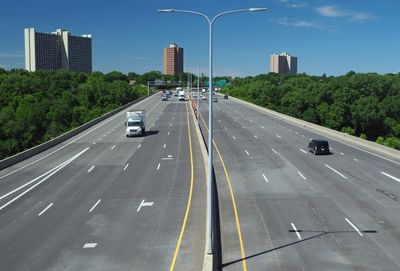
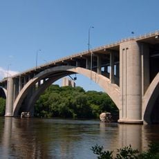
Dartmouth Bridge is a steel road bridge that spans the Mississippi River, connecting Cedar-Riverside with the University of Minnesota campus. The structure carries ten lanes of traffic across more than 300 meters of distance.

The bridge was completed in 1964 and underwent major reconstruction in the 1990s to meet modern traffic needs. This renewal was part of the region's infrastructure development.

The bridge takes its name from Dartmouth Avenue SE, which runs parallel to the northern section of the structure in Minneapolis. It connects two important city areas and shapes how people move between neighborhoods.

The bridge provides direct vehicle access between the two neighborhoods and sees heavy traffic during peak hours. Pedestrians and cyclists should note that this is primarily a highway connection.

The steel girders for construction were transported by barge up the Mississippi River from Gary, Indiana in 1963. This unusual delivery method was necessary to move the heavy components to the building site.

The community of curious travelers

AroundUs brings together thousands of curated places, local tips, and hidden gems, enriched daily by 60,000 contributors worldwide.

Start exploring
Location
Inception
1964
Official opening
1964
GPS coordinates
44.96610,-93.22610
Latest update
December 14, 2025 14:44
Around this place
Huntington Bank Stadium
United States of America

Huntington Bank Stadium

1.2 km
Weisman Art Museum
United States of America

Weisman Art Museum

1.2 km
Memorial Stadium
United States of America

Memorial Stadium

1.1 km
Washington Avenue Bridge
United States of America

Washington Avenue Bridge

1.3 km
Northrop Auditorium
United States of America

Northrop Auditorium

1.4 km
Bell Museum of Natural History
United States of America

Bell Museum of Natural History

1.4 km
Malcolm Willey House
United States of America

Malcolm Willey House

1.5 km
Prospect Park Water Tower
United States of America

Prospect Park Water Tower

1.1 km
University of Minnesota Old Campus Historic District
United States of America

University of Minnesota Old Campus Historic District

1.6 km
Bohemian Flats
United States of America

Bohemian Flats

1.6 km
Milwaukee Avenue Historic District
United States of America

Milwaukee Avenue Historic District

1.2 km
Rarig Center
United States of America

Rarig Center

1.4 km
Coffman Memorial Union
United States of America

Coffman Memorial Union

1 km
University of Minnesota Armory
United States of America

University of Minnesota Armory

1.3 km
Malcom Moos Health Sciences Tower
United States of America

Malcom Moos Health Sciences Tower

904 m
Walter Library
United States of America

Walter Library

1.3 km
Jean-Nickolaus Tretter Collection in Gay, Lesbian, Bisexual and Transgender Studies
United States of America

Jean-Nickolaus Tretter Collection in Gay, Lesbian, Bisexual and Transgender Studies

1.5 km
Short Line Bridge
United States of America

Short Line Bridge

1.5 km
Franklin Avenue Bridge
United States of America

Franklin Avenue Bridge

357 m
Katherine E. Nash Gallery
United States of America

Katherine E. Nash Gallery

1.3 km
Oak Street Cinema
United States of America

Oak Street Cinema

794 m
Old Main
United States of America

Old Main

1.2 km
Tower Hill Park
United States of America

Tower Hill Park

1.1 km
United States of America

University of Minnesota Aquatic Center

1.1 km
Grace Evangelical Lutheran Church
United States of America

Grace Evangelical Lutheran Church

822 m
Luxton Park
United States of America

Luxton Park

598 m
Murphy Square
United States of America

Murphy Square

1.1 km
Prospect Park Residential Historic District
United States of America

Prospect Park Residential Historic District

1 km
Show the full map
Reviews
Share your experience

No review yet

Discussions
Start a discussion...

No discussion yet

« Dartmouth Bridge - Steel road bridge in Cedar-Riverside, United States » is provided by Around Us (aroundus.com). Images and texts are derived from Wikimedia project under a Creative Commons license. You are allowed to copy, distribute, and modify copies of this page, under the conditions set by the license, as long as this note is clearly visible.

Discover hidden gems everywhere you go!

From secret cafés to breathtaking viewpoints, skip the crowded tourist spots and find places that match your style. Our app makes it easy with voice search, smart filtering, route optimization, and insider tips from travelers worldwide. Download now for the complete mobile experience.

Around Us App Screenshot

A unique approach to discovering new places

Le Figaro

All the places worth exploring

France Info

A tailor-made excursion in just a few clicks

20 Minutes

Around Us
Travel Guide & Maps
Download

Send to your phone

QR Code
1

Open the camera app on your mobile.

2

Point at the QR code with your camera. A notification will appear.

3

Tap the notification to open the link.